Download Agreement, Release, and Acknowledgement of Risk:
You (the person requesting this file download) fully understand mountain climbing ("Activity") involves risks and dangers of serious bodily injury, including permanent disability, paralysis, and death ("Risks") and you fully accept and assume all such risks and all responsibility for losses, costs, and damages you incur as a result of your participation in this Activity.
You acknowledge that information in the file you have chosen to download may not be accurate and may contain errors. You agree to assume all risks when using this information and agree to release and discharge 14ers.com, 14ers Inc. and the author(s) of such information (collectively, the "Released Parties").
You hereby discharge the Released Parties from all damages, actions, claims and liabilities of any nature, specifically including, but not limited to, damages, actions, claims and liabilities arising from or related to the negligence of the Released Parties. You further agree to indemnify, hold harmless and defend 14ers.com, 14ers Inc. and each of the other Released Parties from and against any loss, damage, liability and expense, including costs and attorney fees, incurred by 14ers.com, 14ers Inc. or any of the other Released Parties as a result of you using information provided on the 14ers.com or 14ers Inc. websites.
You have read this agreement, fully understand its terms and intend it to be a complete and unconditional release of all liability to the greatest extent allowed by law and agree that if any portion of this agreement is held to be invalid the balance, notwithstanding, shall continue in full force and effect.
By clicking "OK" you agree to these terms. If you DO NOT agree, click "Cancel"...
James Peak 13,294 Feet (404th highest in Colorado; highest in Gilpin County) Southeast Slopes from St. Marys Glacier Trailhead (10,400 Feet) Kingston Peak 12,147 Feet (Unranked)
West Ridge
April 27th, 2008
Approximately 8.2 Miles Roundtrip
Elevation Gained: 3,200+ Feet
Solo
Spring Training
Mount Bancroft (left) and James Peak (center) viewed from Kingston Peak
James Peak is the second-highest mountain in the James Peak Wilderness, which was created by an act of Congress in 2001. The mountain was named for surgeon, geologist, and botanist Dr. Edwin James, who was a member of Major Stephen Long's first expedition in 1820. Edwin James was in the first party of Europeans to climb Pikes Peak, and it was on Pikes Peak that he collected the first specimen of Colorado's state flower, the Colorado Columbine (Aquilegiacaerulea). He was a prolific plant collector during his brief tenure as a botanist, and he is credited with discovering many previously unknown species. James Peak is one of several mountains along the Continental Divide that are named for prominent botanists; others include Grays, Torreys, Parry, and Engelmann Peaks.
There are several different routes that lead to James Peak's summit, but most of the trailheads are inaccessible until May or June. The St. Marys Glacier Trailhead is accessible year-round. It's on a paved, plowed road, and it has ample parking in a private lot. Local entrepreneur Paul Johnson plans to expand the parking lot and improve the facilities in 2008. Chatting with Paul when he came out to collect the $5 parking fee got my hike off to a pleasant start.
I hopped the plow berm and headed up a steep slope into the forest. It was cold and extremely windy, and I was wearing full winter gear: medium base layer, fleece insulating layer, windproof outer layer, Gore-Tex winter boots, goggles, and mountaineering gloves. I started out on snowshoes, because I anticipated postholing problems in the woods and traction problems on the glacier. The narrow trail merged with an old road that headed towards St. Marys Lake. There was plenty of packed snow on the trail. The lake was about half a mile from the trailhead.
The southeast shore of St. Marys Lake
The trail followed St. Marys Lake's southeast shore. The frozen lake was lined with picturesque old limber pines and bristlecone pines. There was about a 50-foot stretch of dry trail, but the snow cover was continuous beyond the lake's north shore.
View of the St. Marys Glacier from the north side of St. Marys Lake
It is generally understood that the St. Marys Glacier is not a true glacier; it is actually a permanent snowfield. The slope is pretty steep, and it is prone to avalanche under certain conditions. The right hand (northeast) side of the glacier is the safest side to ascend. There have been fatal avalanches on the lefthand side of the glacier:
Snow has been plentiful this year, and blowing snow is still accumulating on the slope. There was ankle-deep powder over consolidated snow in the glacier. My snowshoes were useful, but not absolutely necessary.
Looking down at St. Marys Lake from the glacier
The sky was blue and clear, but the wind was horrendous. The 30 m.p.h. breeze drove whirlwinds of icy snow down the funnel-shaped glacier. These conditions are probably not far out of the ordinary for this hike.
Looking up the glacier through clouds of snow
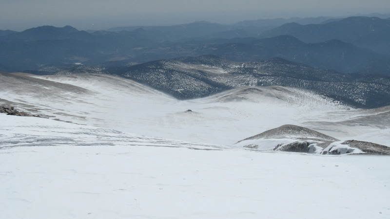
The top of the glacier was about 1.4 miles from the trailhead with an elevation gain of about 1,200 feet. The grade eased considerably at the top of the glacier, and James Peak came into view in the distance. The broad, flat area between the glacier and James Peak is known as Jamaica; Gerry Roach apparently gave it this name because it is adjacent to Kingston Peak (Kingston is the capital of Jamaica) and because Jamaica is a play on words with James Peak. I welcomed Jamaica's gentle grade after grunting up the steep glacier.
James Peak viewed through wind-whipped snow from the top of St. Marys Glacier
There is a large rockpile about 0.4 miles northwest of the top of the glacier; this useful landmark can help hikers find the route back to the trailhead when visibility is poor. It is also the only place in Jamaica to find respite from the incessant wind. It's good to use a GPS or take compass bearings while crossing Jamaica; a pair of hikers got lost in a May blizzard a few years ago, and only one of them survived:
Jamaica's rockpile does double duty as a landmark and a break area
I paused at the rock for a moment to survey the next part of my route. The ridge on the right is a popular route, but it is extremely steep in places. The center of the slope is not as steep, but the upper part could slide under certain conditions. The extreme left hand side of the slope seemed ideal. It didn't appear to be steep enough to slide, and exposed patches of rock led me to believe that the snow was not very deep. I hiked towards the center of the southeast slope, and angled to the northwest to reach the edge of the slope.
The upper part of the route viewed from the rockpile in Jamaica
Measured from the base of the slope, there was still a mile to go and 1,200 feet of elevation to gain. I planned to take the path of least resistance to the summit.
James Peak's upper slopes viewed from about 12,200 feet
Conditions were excellent on the slope. I could have hiked on exposed rock, but I chose to take a less bumpy route on shallow snow. I spotted a cairn that didn't really appear to mark anything. After a few minutes, I spotted another substantial cairn and a short stretch of exposed trail. I took off my snowshoes and decided to try to boot it to the summit.
A well-constructed cairn at 12,400 feet on James Peak's southeast slope
Looking back at my route from 12,400 feet; Kingston Peak is to the left, the flat plain in the center is Jamaica, and the rockpile guards the entrance to St. Marys Glacier
I could see most of the remaining route from the cairn at 12,400 feet. The cairns on this route were huge, and they could be seen from a considerable distance. The trail was apparently designed to avoid as much snow as possible. Navigation was effortless from this point forward.
The cairned route on James Peak's southeast slope
At 12,800 feet, I crossed a snowfield and moved due north towards the summit. A massive cairn helped me pick up the trail on the other side of the snowfield.
A broad snowfield at 12,800 feet
The icy trail winding through talus towards the summit
The upper slope was not very steep. I followed some boot prints until they led me into some deep snow. After postholing for a few minutes, I determined that the tracks had led me off-route. I spotted the trail just a few feet away, and found that the path was clear all the way to the summit.
The final push to James Peak's summit
Wind shelter on the summit
I made my way towards the summit wind shelter, anxious to drop my pack and take a break. I crouched as low as possible to avoid the stiff breeze. There was a cable for a summit register, but the tube was nowhere to be found. The water bottle in my Napoleon pocket was frozen solid, and my Clif bar was so hard that it was virtually inedible. In spite of the winter-like conditions, the brilliant blue sky reminded me that better weather was just around the corner.
James Peak summit shot. Parry Peak is by my left elbow; Mount Bancroft is beside my right hip; the twin peaks just above Mount Bancroft are Grays and Torreys.
Mount Bancroft was the closest mountain to the south. There is a Class 5.2 traverse between James Peak and Mount Bancroft, but I'm not really up for that one. The Class 2 southeast ridge looks pretty tempting, though.
Mount Bancroft from the north
Parry Peak was a short distance west of Mount Bancroft. It is the highest mountain in this group at 13,391 feet. The Class 2 route from Fall River Reservoir is the easiest way to ascend Parry Peak.
Parry Peak from James Peak's summit
There was quite a bit of snow blowing around, but the route back to the glacier was still clearly visible.
Looking down towards St. Marys Glacier from James Peak's summit
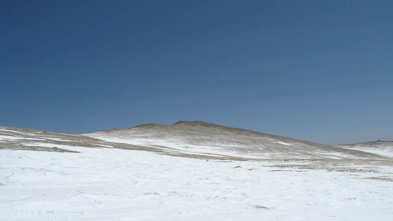
I enjoyed a short break on the summit, and then started back down my ascent route. I wanted to check out the unranked 12er Kingston Peak on the way back. Kingston Peak only rises about 400 feet above the tundra of Jamaica, so this did not require a great deal of effort.
Kingston Peak viewed from the base of James Peak
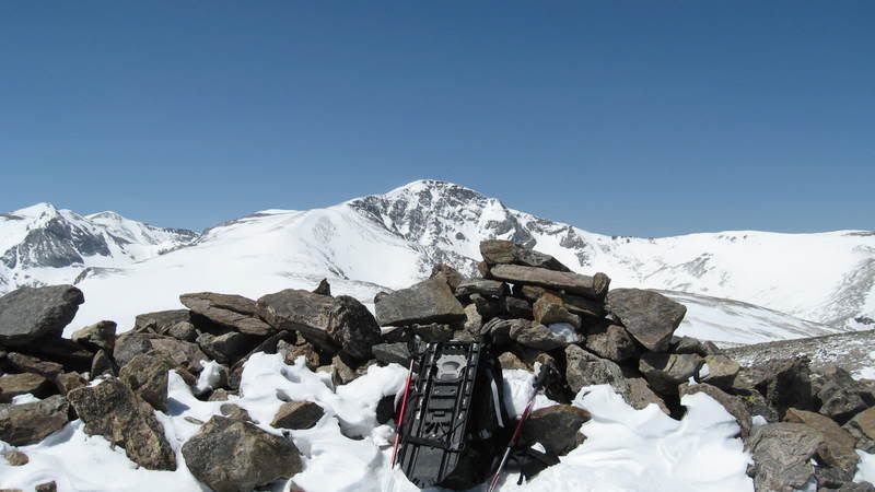
I followed part of an old mining road up Kingston Peak's west side, then booted it the rest of the way on mostly wind-scoured tundra. There was a rudimentary wind shelter on the summit, and the view of James Peak was incredible. The wind threatened to knock me down several times, so I surrendered and headed back towards the glacier.
James Peak viewed from Kingston Peak's summit
The snow was still howling down the glacier, but fortunately the wind was at my back. I was still packing my snowshoes, so I looked for the firmest snow on the northeast side. About halfway down the glacier, I met the first hiker that I had seen all day. There were several more snowshoers down around St. Marys Lake.
Looking down the St. Marys Glacier towards Fox Mountain (the steep cone just right of center) and Silver Lake (behind and to the left of Fox Mountain)
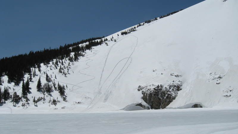
When I got to St. Marys Lake, there were a couple of snowmobiles sitting on the ice. They had just highpointed the steep slope on the west side of the lake. It looked like quite an adrenalin rush, but it was a bigger risk than I would be willing to take. Soft-slab avalanches are not unheard of on this slope:
Snowmobile tracks on the slope to the west of St. Marys Lake
The St. Marys Glacier/James Peak hike is a Colorado classic, and should be on every snowshoer's to-do list. It's a strenuous hike, but it rewards the hiker with miles and miles of outstanding scenery along the Continental Divide.
Thumbnails for uploaded photos (click to open slideshow):
It's funny, I've been on St Mary's Glacier probably 10+ times for practicing self arrest, rope team travel, crevasse rescue, winter camping, etc, but I have never been to the summit of James Peak! Its nice to see what it actually looks like from this vantage point!
Good info (weather, avy slopes, historical notes). I hear‘ya with the wind and snow: so much for ”La Nina” - Mother Nature has been a real be-itch!
Caution: The information contained in this report may not be accurate and should not be the only resource used in preparation for your climb. Failure to have the necessary experience, physical conditioning, supplies or equipment can result in injury or death. 14ers.com and the author(s) of this report provide no warranties, either express or implied, that the information provided is accurate or reliable. By using the information provided, you agree to indemnify and hold harmless 14ers.com and the report author(s) with respect to any claims and demands against them, including any attorney fees and expenses. Please read the 14ers.com Safety and Disclaimer pages for more information.
Please respect private property: 14ers.com supports the rights of private landowners to determine how and by whom their land will be used. In Colorado, it is your responsibility to determine if land is private and to obtain the appropriate permission before entering the property.