Download Agreement, Release, and Acknowledgement of Risk:
You (the person requesting this file download) fully understand mountain climbing ("Activity") involves risks and dangers of serious bodily injury, including permanent disability, paralysis, and death ("Risks") and you fully accept and assume all such risks and all responsibility for losses, costs, and damages you incur as a result of your participation in this Activity.
You acknowledge that information in the file you have chosen to download may not be accurate and may contain errors. You agree to assume all risks when using this information and agree to release and discharge 14ers.com, 14ers Inc. and the author(s) of such information (collectively, the "Released Parties").
You hereby discharge the Released Parties from all damages, actions, claims and liabilities of any nature, specifically including, but not limited to, damages, actions, claims and liabilities arising from or related to the negligence of the Released Parties. You further agree to indemnify, hold harmless and defend 14ers.com, 14ers Inc. and each of the other Released Parties from and against any loss, damage, liability and expense, including costs and attorney fees, incurred by 14ers.com, 14ers Inc. or any of the other Released Parties as a result of you using information provided on the 14ers.com or 14ers Inc. websites.
You have read this agreement, fully understand its terms and intend it to be a complete and unconditional release of all liability to the greatest extent allowed by law and agree that if any portion of this agreement is held to be invalid the balance, notwithstanding, shall continue in full force and effect.
By clicking "OK" you agree to these terms. If you DO NOT agree, click "Cancel"...
First report, 8th 14er, maybe I'll get around to writing the more interesting ones soon. But this was my first solo ascent, so I thought I might write a TR on it.
I was originally planning on doing the West Ridge with my roommate, but he bailed out on me when I got home from work at 11 pm. And despite the fact I had only gotten 3 hours of sleep the two previous nights, I was oddly awake. It crossed my mind to attempt a sunrise trip, but obviously I couldn't head up the West Ridge solo in the dark. So as midnight and 1 am crept up, and I still wasn't tired, I started getting things ready, ate a sandwich, filled up with gas, and left for Quandary's East Ridge at 2:45 am.
I figured I wouldn't make the summit by sunrise, but was hoping to be high enough to have little to no obstructions for the crack of dawn. It was quite dark, and the stars were amazing. In fact, as I was heading down I70 just past Eisenhower, I saw the brightest shooting star I've ever seen. It was so bright and prominent that it actually startled me. I arrived at the trailhead, double checked all my gear/food, and started up the trail at 4:30.
I had hiked in the dark before, but both times were with other people. It was rather unnerving at times when I was solo. I was certain every odd noise my pack would make must have been some animal just watching me. My Nalgene made a distinct sound at least three times, and every time I heard it, I jumped. But other than being a little paranoid, hiking in the dark is nice. It is cool, the going is quick, and you (mostly) don't have to worry about running into other people.
Nonetheless, when the sky began showing signs of day, I felt re-energized.
Knowing I wasn't going to make it to the summit early enough, I slowed my pace and appreciated the beauty all around. My camera sucks, so it lacks the ability to capture stars, so I just focused on the upcoming light.
Sun coming over Grays and Torreys
Lincoln group
The dam and reservoir
The sky to the West had an almost rainbow appearance across the horizon, however, pictures don't do justice.
Wait for it...
There it is
I took a lot of pictures of the sun, almost as good as an eclipse.
A rather orange morning
Just about 13,200, when it gets steeper, my legs and knees were telling me that I hadn't slept in 24 hours. I took my time from there, and tried to keep up a steady pace without breaking. Thirty minutes later I was at the summit.
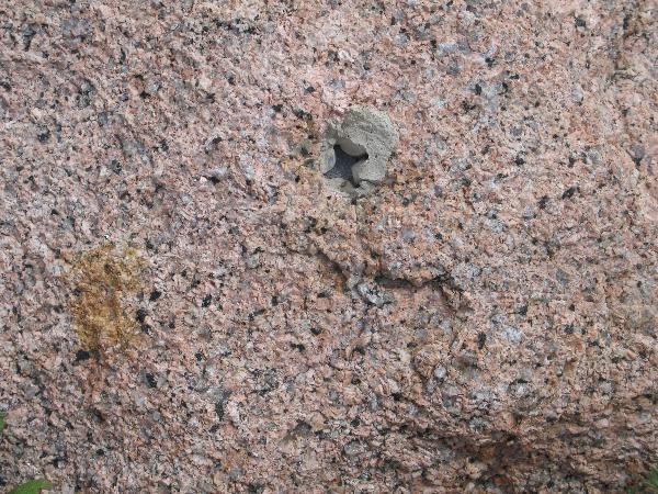
This one looks a little beat up. Do you think you could put up another one, Bill?
Multiple USGS benchmarks
After my first time skiing at Copper, this quickly became my favorite ridge in Colorado. Maybe someday I'll climb it.
A close-up of the Elks (bad quality). Snowmass immediately stands out.
Holy Cross
After my photo op on the summit, I ate a sandwich, drank some water, and listened to some music. As suggested by lordhelmut, I listened to some Enya on the summit. However, I found John Denver a lot more relaxing. The instrumental theme to Lord of the Rings was also great. I stayed on the summit for about 40 minutes, then headed back down. I didn't see a soul other than this guy for about thirty minutes.
He felt the need to be relaxing in the middle of the trail, while I was concentrating on my feet as I half ran/slid down the mountain. I probably would have run into him if his brother hadn't jumped up when I was about 20 feet away. So, I just slowly walked around the trail, and he just relaxed.
Saw thirty or forty people after that.
Trailhead to summit: 2:00
Summit: 40 minutes
Summit to trailhead: 1:15
I stopped twice on the way home, at Bakerville and Idaho Springs, and slept over an hour at each place. It took me longer to get home than it did to get up and down the mountain
Thumbnails for uploaded photos (click to open slideshow):
Few people know this, but of the two pictures, you have a BM and a RM (Reference Marker. Reference Markers normally have arrows on them pointing in the direction of the BM station. There can be multiple RM‘s on a summit if it is likely the BM is difficult to find.
Looked like a fun sunrise. I am thinking about one of these types of climbs. Good report.
I was wondering why they would put two ”benchmarks” up there, but that makes sense. The actual BM is so obvious, though, I don‘t see the need for the RM. And I definitely recommend a sunrise hike. Solo was nice, but I‘ll probably try to find a partner for my next one.
Another reason for the reference marks are redundancy. USGS records will hold measurements from RMs to the Benchmark station in case the BM is destroyed. It gives a local and easy reference to make a measurement if they decide to come back on a survey. Based on your picture, it looks like there is (or was) probably another RM up there (yours is identified as NO 2). I have been on many mountains where one or more of these marks are missing, but one can find the pinhole if you know the measurements from a RM. Below are examples from Mt. Rosa where there were two RM and the Station. Only one RM remains.
Station Location - Mt Rosa
There are over 700K BM in the US and only recorded findings of less that 70K in resent years. There are efforts to note status on many of these markers to help the USGS update their records. I‘m not that active, but it is kind of fun to find one that hasn‘t been recorded in recent years (normally, that is not an issue on a 14er).
Caution: The information contained in this report may not be accurate and should not be the only resource used in preparation for your climb. Failure to have the necessary experience, physical conditioning, supplies or equipment can result in injury or death. 14ers.com and the author(s) of this report provide no warranties, either express or implied, that the information provided is accurate or reliable. By using the information provided, you agree to indemnify and hold harmless 14ers.com and the report author(s) with respect to any claims and demands against them, including any attorney fees and expenses. Please read the 14ers.com Safety and Disclaimer pages for more information.
Please respect private property: 14ers.com supports the rights of private landowners to determine how and by whom their land will be used. In Colorado, it is your responsibility to determine if land is private and to obtain the appropriate permission before entering the property.


")
")
")
")
")
")
")
")
")
")
")
")
")
")
")
")
")
")
")
")