Download Agreement, Release, and Acknowledgement of Risk:
You (the person requesting this file download) fully understand mountain climbing ("Activity") involves risks and dangers of serious bodily injury, including permanent disability, paralysis, and death ("Risks") and you fully accept and assume all such risks and all responsibility for losses, costs, and damages you incur as a result of your participation in this Activity.
You acknowledge that information in the file you have chosen to download may not be accurate and may contain errors. You agree to assume all risks when using this information and agree to release and discharge 14ers.com, 14ers Inc. and the author(s) of such information (collectively, the "Released Parties").
You hereby discharge the Released Parties from all damages, actions, claims and liabilities of any nature, specifically including, but not limited to, damages, actions, claims and liabilities arising from or related to the negligence of the Released Parties. You further agree to indemnify, hold harmless and defend 14ers.com, 14ers Inc. and each of the other Released Parties from and against any loss, damage, liability and expense, including costs and attorney fees, incurred by 14ers.com, 14ers Inc. or any of the other Released Parties as a result of you using information provided on the 14ers.com or 14ers Inc. websites.
You have read this agreement, fully understand its terms and intend it to be a complete and unconditional release of all liability to the greatest extent allowed by law and agree that if any portion of this agreement is held to be invalid the balance, notwithstanding, shall continue in full force and effect.
By clicking "OK" you agree to these terms. If you DO NOT agree, click "Cancel"...
Peaks Climbed
Vestal
Arrow
West Trinity
Trinity
East Trinity
Peak 9
Storm King
Peak 5
Peak 6
Jagged Mtn
Leviathon Pk
Knife Point
Coxcomb
Drainages
Vestal/Elk Creek
Tenmile
No Name
Cimarron (Coxcomb)
Elevation Gain = 31,200 ft (according to Chris‘ gps)
Mileage = 58.6 miles total (including Coxcomb)
I remember emailing Kiefer (Skasgaard) a ways back around February about a possible trip into the Weminuche Wilderness late this summer. His definitive yes to the idea both gave me a partner for the trip and the go ahead to begin planning for it. We met for the first time at the Barnes and Noble in Boulder to go over the gory details. The original plan was to climb all the Grenadiers in Vestal Basin, traverse over into No Name for a shot at Jagged, climb everything in Ruby Basin and finish off the 14er group in Chicago Basin. Fast fowarding to July, two guys jumped on the trip, one of whom knocked some sense into me. Chris Ferraro, a guy I climb with often, who also happens to be my neighbor and sports an interesting mix of facial hair styles differing on a monthly basis, suggested we nix the Ruby/Chicago plans and climb more peaks. I was hesitant at first cause Pigeon Pk was atleast a quarter of the reason for this trip and another huge Centenniel for Kiefer, but after a few beers and a trip back to reality at a local watering hole in Vail, we all realized this would be for the best.
Now for the trip. Chris picked me up after work on the 15th and we crawled our way out of a wet Denver en route to Vail to meet up with Kiefer. Kiefer was ready to roll with all his gear, rope, pro, you name it in his brand new 85 Liter Osprey. After some brief downloading of a diverse mix of death metal, classical and rock on to his ipod, we hit the road once again for Ouray to meet up with Glen. Glen, just recently being appointed a fireman in the town of Parker, could only join for a small portion of the trip, luckily, in my opinion, the highlight of the trip, The Wham Ridge.
Arrival time into Ouray was around 11pm or so, Glen had been waiting for us at the classy Riverside Inn cabins. It looked more like a halfway house than anything else, but it didn‘t matter too much, considering we were there for less than 8 hours and had a flask of Jameson and a few beers to make the sleeping easier.
Day 1/2 - pack in from Elk Park/Vestal via Wham Ridge and Arrow via standard route
We woke up to a cloudy morning in SW Colorado. The drive down to Durango was a tad demoralizing since we saw about 15-20 significant lightning bolts going off all around us at 6am in the morning. Nevertheless, we got our last meal at the Mcdonald‘s across from the train depot and boarded with high hopes despite the weather to the North. Quick thing about the train. I knew I had vowed to never step foot in that shitbox again, but given the details of the trip and the number of drainages we‘d end up south of where we started, it made things a lot easier, plus gave us a chance to celebrate the end of our trip the way it should be with a last hoorah in Durango when we got off the train.
The train dropped us off at Elk Park around noon, conductor bid us goodluck, we met up with Glen (who started from Molas Pass since he‘d only be with us for the Grenadiers) and quickly made our way up the trail towards the surreal region of the Grenadiers. Besides a quick hail session a little ways before the beaver ponds, the hike in was uneventful. The trail is very solid all the way in and the beaver ponds, as a landmark, couldn‘t be any easier to locate. Here‘s a shot of our view of Vestal and Arrow from the ponds :
The creek crossing was easier than expected, there was a nice log bridge built and the water level was pretty low. We crossed paths with quite a few other climbers and backpackers, all very friendly and had a lot of good and terrifying things to say about their excursions in the region, including a guy and his girlfriends adventure up the Wham.
About 4 and a half hours later, we were treated with a front row view of the Grenadiers :
And then a fine camping spot @ 11,400 ft with this view of the Trinities to the East :
After a superb tortolini dinner prepared by Glen, we hit the sacks in hopes of summiting Vestal and Arrow in the morning.
Alarm went off around 4:30am (this would be the norm for wake up for the duration of the trip pretty much). From our campsite, which happened to be one of the furthest east in the basin, all we had to do was cross the stream and immediately begin our ascent towards Wham yards from the other side.
We reached the Wham very easily and made our way for the top of the grass ramps to access the western edge of the face to begin our ascent.
Kiefer pumped to touch foot on the base of the Wham
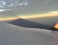
And the sky caught fire when the sun hit the clouds
We traversed the grass ramps right to the edge of the face with no problems. It had yet to really get steep yet and we got a good glimpse of things to come when we reached the ridge crest.
Glen approaching our entrance to the climb with Arrow in the background
And our route up the great, daunting Wham Ridge
Kiefer and I opted to put on our rock shoes for safe measure, Glen and Chris felt comfortable in their backpacking boots. We also had hauled up a 60 meter rope with various protection gear to be extra safe, especially since most trip reports we had read involved all this stuff.
The ridge gradually got steeper and steeper as we made our way up, but the holds were very solid and very frequent. Here was a shot of the crux of the route more or less :
Chris took the flat face to the left, which had more exposure below him but better and more prevalent, obvious holds. Glen, myself and Kiefer decided to take the route to the left, which may have had a tad tougher single moves with less holds, but there was less air under our feet and a significant drop off to the right, which happened to be the end of the ridge. Chris‘ route was the more courageous of the two. I remember looking up at Chris after he let up his concentration and he said something along the lines of "I guess that was the crux??". I remember looking around and responding, yeah, you‘re right". None of us felt any need to take out the rope, for our pace was solid up to this point and we were all very comfortable with the exposure, which we all felt was manageable thus far. After the crux, things never really got any harder, just a lot steeper. Here‘s an idea of how steep things got near the false summit, and this is no exageration :
Kiefer and I reached the false summit at the top of the Wham and saw Chris and Glen topping out on the true summit across the way. We were all siked to have gotten this one off our backs, each of us had been wanting to climb this route for a very long time and now we had it all to ourselves with an IMAX view of the rest of the Weminuche.
Glen and Kiefer on the summit of Vestal
On a side note, Pigeon Peak is the monarch of the Weminuche when looking south from the Grenadiers, this much we all agreed. Its NW face was mesmerizing and even though we had all just climbed the Wham, there were already plans in the works for a trip down there next summer, it was that enticing.
The climb off the South route of Vestal was surprisingly tedious. I don‘t think we stayd on route the whole time and found ourselves downclimbing 4th class rock at times. I vaguely remember passing by a sling at one point. We made it to the Vestal-Arrow saddle a bit later and then made way for the class 3 ramp (we called it "wham ramp", how uncreative) leading up to Arrow‘s summit. The ramp wasn‘t nearly as steep as Wham‘s ridge, but was a fun scramble nevertheless. We ran into a guy and his friend just under the summit, talked for a bit and that would be the last person we‘d run into in 5 days. We fueled up on the semi-exposed summit of Arrow and with building clouds in the region, made our way back to camp for some hot grub. Some shiots of Arrow :
The "ramp" from Vestal
descending the slabby ramp towards the basin
Day 3 - Trinity Traverse w/ traverse from Vestal Basin to Tenmile Basin, camp @ Balsam Lake
Glen had to head back to Denver for some extensive academy training for his new job and decided it‘d be best to skip the Trinities and make his way back to Molas Pass that next morning. He was feeling a little under the weather anyway and had a lot to do back home, so we parted ways after breakfast and directed out course towards the saddle between Vestal and W.Trinity. We had left our climbing gear near the saddle after our climb the prior day and hauled up the rest of our stuff to drop off, since we‘d be passing by at the end of the day en route to the saddle dropping us off into Tenmile Basin.
The route up towards the edge of the pass on the climber‘s left side was loose, but short. We gained the saddle and made our way for the summit of West Trinity via a quick, class 2/3 ridge. After a few false summits, we topped out still early in the morning.
Our view of the traverse over to Middle Trinity
The traverse over to Trinity Peak was a lot more complex than we‘d expected. For some reason, I can‘t remember the route that well or even standing atop the summit, all I can say is listen to Cooper‘s description, it certainly helped us a bit. One word of advice though, you don‘t have to drop down as much as you think.
The view of the remainder of our trip to the South, with one of our high camps to the right of Pk 7, the peak in the obvious foreground and up and to the right of the large blue Balsam Lake, along the grassy slopes
And our last objective of day 3, E.Trinity, which looks harder than it really is
I think this is Chris on top of Middle Trinity taking shot West towards the western Grenadiers
Anyways, the route from Trinity takes you down a loose, steep gully towards the small saddle and then once on the saddle, you have a sursprisingly fun scramble to E.Trinity.
The downclimb off E.Trinity was probably the most fun of the day, which is crazy cause downclimbs are never any fun. These two shots of Chris and Kiefer descending are why I felt this way :
Kiefer w/ Vestal Basin in the background
And our last view from a summit in Vestal Basin (Rio Grande Pyramid w/ the Window)
The climber‘s trail was relatively easy to follow as we side hilled along the slopes of the Trinities back towards our gear at 12,300 ft near Vestal Lake. We reached out untouched packs around mid-afternoon, took a break and then made our way back up the saddle we had gained earlier that morning, this time to access Tenmile Basin and the rest of our peaks and adventures that awaited us (and no one else, at least not this week)........
Thumbnails for uploaded photos (click to open slideshow):
On the simpsons there are some alien creatures that try to takeover once in a while. Anyway, one of those guys says, ”holy flurking shnit!” in one of the episodes. That was the first thing that came to my mind when reading this. Seriously. Way to get er done.
on a great trip, guys! vestal was the first san juan peak i climbed, so your TR brings back sweet memories. i‘ve always thought that if i did it again, i‘d free solo it just like you guys did. looking forward to the rest of your trip writeup!
Those are some really cool peaks you guys tackled. Did you scope out Grey Needle for me ? Kiefer promised a lead for me next summer. Don't think negative about slimming down the original plan; the Weminuche is a great place to go back to again and again.
Dam, Brian! Here I am having trouble recollecting everything for a report for 14erworld and I see this! Many thanks!
Sweet write-up, man. The defining trip of 2008.
Steve: I took some close up shots and a pan of the east side of Grey Needle. Though in all honesty, it's hard to distinguish from No Name Needle. As soon as I clean them up & make sense of the route, I'll send them to you.
A lead, eh?
...how jealous and dismayed I am at not being able to come along for what looks like the trip of the year. I‘m stoked to hear you‘re heading back next year for Pigeon.
Which was more daunting, the BK drive-thru in Durango, or the Wham Ridge?
Simply awesome.
Caution: The information contained in this report may not be accurate and should not be the only resource used in preparation for your climb. Failure to have the necessary experience, physical conditioning, supplies or equipment can result in injury or death. 14ers.com and the author(s) of this report provide no warranties, either express or implied, that the information provided is accurate or reliable. By using the information provided, you agree to indemnify and hold harmless 14ers.com and the report author(s) with respect to any claims and demands against them, including any attorney fees and expenses. Please read the 14ers.com Safety and Disclaimer pages for more information.
Please respect private property: 14ers.com supports the rights of private landowners to determine how and by whom their land will be used. In Colorado, it is your responsibility to determine if land is private and to obtain the appropriate permission before entering the property.


")
")
")
")
")
")
")
")
")
")
")
")
")
")
")
")
")
")
")
")