Download Agreement, Release, and Acknowledgement of Risk:
You (the person requesting this file download) fully understand mountain climbing ("Activity") involves risks and dangers of serious bodily injury, including permanent disability, paralysis, and death ("Risks") and you fully accept and assume all such risks and all responsibility for losses, costs, and damages you incur as a result of your participation in this Activity.
You acknowledge that information in the file you have chosen to download may not be accurate and may contain errors. You agree to assume all risks when using this information and agree to release and discharge 14ers.com, 14ers Inc. and the author(s) of such information (collectively, the "Released Parties").
You hereby discharge the Released Parties from all damages, actions, claims and liabilities of any nature, specifically including, but not limited to, damages, actions, claims and liabilities arising from or related to the negligence of the Released Parties. You further agree to indemnify, hold harmless and defend 14ers.com, 14ers Inc. and each of the other Released Parties from and against any loss, damage, liability and expense, including costs and attorney fees, incurred by 14ers.com, 14ers Inc. or any of the other Released Parties as a result of you using information provided on the 14ers.com or 14ers Inc. websites.
You have read this agreement, fully understand its terms and intend it to be a complete and unconditional release of all liability to the greatest extent allowed by law and agree that if any portion of this agreement is held to be invalid the balance, notwithstanding, shall continue in full force and effect.
By clicking "OK" you agree to these terms. If you DO NOT agree, click "Cancel"...
Peak(s):
Signal Peak - 4877
Smith Peak - 5242
Harcuvar Peak - 4618
Camelback Peak - 2704
The Plan
It was the start of 2009 and CODave (Dave) and I were already growing weary of winter's cold grip so we had started to discuss a possible getaway to somewhere where we could enjoy some warm weather hiking. Dave kept suggesting we visit AZScott (Scott) in Phoenix and after watching airline tickets return back to earth after last year's high prices I was convinced that going to Arizona would be a welcome change of scenery (plus I was born there so I felt like I was returning back to my roots). We bought our tickets, but then had to wait for what seemed like the longest four weeks ever, maybe it was the anticipation of going cougar hunting in Scottsdale that made the wait seem so long (if you have ever been to Scottsdale you will know what I mean). Unfortunately three days before we were to leave I woke up to incredible abdominal pains and for two days a nasty stomach flu ravaged my insides and made me wonder if going to Arizona was a good idea. Lucky for me the symptoms started to subside the night before we were to leave so I packed up my things and told Dave I would pick him up the next day.
Thursday, February 19th had finally arrived and after working a half day I left the office, picked up Dave, headed off to the airport and after a short flight we were in warm and sunny Phoenix. Scott picked us up promptly curb side and the OMG's (original mountain gangsta's) were back in action again for another jihad adventure. That night we went out to dinner with some of Scott's friends (his friend Brian would be joining us for our desert adventure) then went back to Scott's place to talk about our upcoming adventure; Dave and Scott each enjoyed a 40oz of Colt 45 (I wasn't ready to upset the digestive system yet given the previous days' stomach flu). Since Dave and I were on vacation we had left most of the planning up to Scott and he had created an itinerary starting the next day with Smith Peak (Friday), Harcuvar Peak on Saturday and finishing with Signal Peak on Sunday, the high point of Yuma county. All three peaks are part of the 73 peaks in Arizona with 2000+ feet of prominence.
Smith Peak
With no threat of thunder storms and a full day of sunshine in our future, we rolled into our first day of hiking at a snail's pace. We all met up at Brian's place and waited for the last member of our group, Scott's friend Tim, to pick us up in his modified Jeep Grand Cherokee. After loading up the jeep, picking up food and beer at the grocery store we set off to conquer the Arizona desert. We drove about two hours NW of Phoenix to the small town of Aguila; a small, dusty, one gas-station town where the kids still play in the street to the sounds mariachi music. From here we headed north towards the trailhead for Smith Peak. Soon after we left the highway I learned why we need the modified jeep. The roads here are rugged and primitive and most of the time completely unmarked. At this point I began to really appreciate what Bill and Gerry have done when it comes to providing directions to the TH's for the Colorado 14ers because in the desert you basically drive until the road runs out or you come to some impassible object.
The road we were following towards Smith peak eventually ran out, however we all felt we were at an adequate starting place so we all filled up our water bottles, donned our packs and hit the trail.
Dave, Scott and Brian prepare to lead the way up Smith Peak. The trail we followed is visible on the right.
Nothing says leisure hiking like a nice 2:00 pm alpine start. The weather was a perfect mid 70's and Dave, Scott, Brian and Tim set a grueling pace up what looked like the remnants of an old 4wd road. I was still feeling the effects of the stomach flu and lagged behind by a couple minutes, although the overall pace was still pretty quick. At the top of the abandoned 4wd road we actually met up with a well maintained dirt road used to service the numerous radio towers on top of the Smith Peak.
Smith Peak is visible in the distance with all its radio towers. The service road is also visible.
We followed this road to the 5,242 foot summit of Smith Peak. The hike was uneventful and although the view from the top was quite scenic, something just didn't feel right as we rested in the shadows of countless radio towers.
Dave, Scott, Tim and Brian make the final grueling summit push to the top of Smith Peak.
It was also at this point that thought to myself and realized I was not impressed with Arizona desert peaks (later I also realized this was my 100th unique summit, what a quality summit). We stopped briefly for a snack and a summit beer and quickly headed back down knowing we still needed to drive to the trail head of Harcuvar peak by nightfall.
From R-L Tim, Brian, Scott, me, and Dave pose for the obligatory summit shot on Smith Peak. We were probably all sterile at that point since we had been sitting on the summit near the radio towers for about 20 minutes.
The stats for the day were a modest 6 miles, 2,350 feet of elevation and a round trip time of just over 3 hours. For me it was a small victory given I was able to keep everything I ate down and I didn't feel like I was lagging behind too badly.
The view of the valley floor from the trailhead of Smith Peak.
Harcuvar Peak
We drove 25 miles to the town of Wenden and again headed north into the desert on a variety of unmarked dirt roads. Scott had warned us this would be the toughest trailhead to find and even with two GPS's and a detailed topographic road map Scott's prediction was correct and there was plenty of frustration in finding our way towards Harcuvar Peak as the day's last rays of sunshine slowly vanished. With some crafty driving by Tim we found a good stopping point and decided it would be home for the night. It was only after I went back to the jeep to retrieve more gear for the night that I realized the jeep had a flat tire, the kind where fix a flat was not going to solve our problem. We quickly changed out the tire for the spare and prayed to the tire gods to be kind to us because getting stranded in a place like this is not where you want to be. That night for dinner we grilled up some dogs and drank a copious amount of beer (well except me as I was still was not feeling 100%). Dave, Tim and I were in tents, since we didn't want to deal with the morning scorpion surprise, and Scott and Brian, being the desert professionals they are, slept under the stars on a tarp.
The next morning started off again with the casualness that seemed to be the theme of the trip.
The view of Harcuvar peak from our campsite. Our ascent route follows the ridge right of center just below the horizon. Our descent route follows the ridgeline that forms the right side of the horizon.
We started up the mountain at 9:15am and followed the remnants of a road / old miner's trail for about a half a mile where we were faced with our first decision of the day; do we continue on the old miners trail to an obvious saddle or should we just bushwhack up the side of the mountain for a direct approach of the summit. I was kinda pulling for the saddle route since I knew the grade would be less steep and I didn't think I was feeling 100% yet. The rest of the group wanted to go for the direct approach up a faint ridge that ran down the southeast face of the mountain. Dave, Scott, Tim and Brian again led the way with me trailing behind. We made quick work of the remaining 0.6 miles, reaching the 4,618 foot summit of Harcuvar Peak a mere 1 hour 15 minutes after we left camp. The summit of this peak redeemed Arizona climbing for me and I felt like I was starting to get my energy back. We relaxed on the summit of this remote peak for a good 45 minutes taking in the sweet views of the desert floor below us. According to the climbers log we were the first to visit in almost three months. Our decent route took us over a sub-summit and down what I thought was going to be the gentle north east ridge to the saddle we had seen that morning.
Looking back over the sub-summit towards the true summit of Harcuvar peak.
The gentleness quickly steepened and we were bushwhacking our way back down a small gully full of plants that poked, stabbed, and cut at your skin and clothing. Coming down these loose rocky slopes takes more skill then I thought because one wrong step and you end up falling into a cactus.
Dave becomes reunited with his favorite plant in the desert, cat's claw. This truly has to be one of the most evil plants in the world as each branch is armed with numerous backwards angled thorns that tears up your clothing and shreds your skin.
It turned out that the return route added about a mile to the round trip milage. The day's stats were an easy 3.5 miles, 2020 feet of elevation and a round trip time of 3 hours 40 minutes.
The car was quickly packed up and after a brief stop in Wenden for lunch we off to search for a spare tire knowing we still had one more 4wd adventure ahead of us to get to the Signal Peak trailhead.
We couldn't resist stopping at a place that advertised Warm Beer, Lousy Food and Bad Service. It ended up being a great place to grab good grub and cheap beer. You are even greeted with a double barrel shotgun hanging from the ceiling when you make your way into the bar.
Signal Peak
Forty miles to the southwest of Wenden is the craptacular town of Quartzville, Arizona. It is dominated by RV sales lots and thousands of people who drive their RV's and campers into the desert for the winter. It is a phenomenon that I just can't understand as I looked out over the desert and saw miles of trailers, campers and RV's parked next to each other. After realizing we weren't going to find a spare tire we restocked our food, got some Schlitz beer and headed due south for the jewel of the trip, Signal Peak. The peak stares you down almost the entire 20 mile trip south out of Quartzville and just like Capitol Peak you wonder where the ascent route is goes.
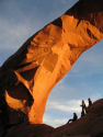
The view of the frontside of Signal Peak. The valley that cuts the face of the mountain in half is home to the only naturally growing palm trees in Arizona.
The ascent route actually goes up the backside of the peak so we had yet another long 4wd approach through a dried out wash. This peak had the closest thing to an actual trailhead and for the first time in our trip there were people actually camping at the trailhead so we decided to head up the valley a little farther. We found a nice flat sandy place to set up camp, however the washes can get pretty cold at night, so we were faced with turning in for the night at 8 pm or trying to find something to burn in the desert to keep warm.
A great desert sunset.
Being the resourceful OMG's that we are, we were able find a few dead items in the wash, which was just enough to get a fire started. As we all settled around a warm campfire out came the Schlitz beer (kiss the hops) and we all pondered how many BTU's are in one dead agave plant (who knew they had other uses other than making tequila).
I enjoy the cold refreshing taste of Schlitz beer while sitting around the campfire, this beer screams quality.
The next morning started much like the rest of the trip with us hitting the trail a little after 9 am. We followed what looked like a trail for the first 0.3 miles when we made an incorrect right turn. We continued another 0.3 miles into a side canyon with ever steeping walls before we stopped to ponder our future. We knew we were not on trail, but the debate was where do we need to go and how do we get there. In the end our detour added an additional 0.7 miles and 250 feet. On our way back to rejoining the trail Dave spotted a snake that I had almost stepped on. We quickly identified it as non-poisonous so I reached down and picked it up. Since we were in a shaded canyon it was still pretty cold so I think it enjoyed the warm of our hands and after snapping a few pictures we put it back in its home; Brian later identified it as the shy Desert Rosy Boa, a rare find indeed.
Dave handles the desert rosy boa, one of only two boa species native to North America.
We bushwhacked awhile and were able to find a faint climbers trail that headed up the correct canyon; the correct canyon heads basically SW whereas the wrong canyon heads to the NW. The next part of the hike climbed steeply up the gut of the canyon to reach a small plateau where we paused for a quick snack. We continued on until we lost the trail again, however after a little searching around we were able to find it again on the other side of a dry creek bed heading up a side canyon. If measuring from the trailhead, after you have traveled a little over a mile a side canyon that heads to the NW should be visible, you will need to head up this side canyon to reach the summit. The remaining route involved some fun rock hopping through a dry creek bed and although the route is rated class 3 I believe at most it may have reached 2+. We topped out of the canyon on some fun rock to an easing grade with a false summit visible directly ahead and another false summit to our climbers left.
After topping out of the side canyon, Brian, Scott and Tim head towards the saddle of the two false summits. The true summit can not be seen in this photo.
After much adventure and after visiting most of the false summits we enjoyed the best views of the trip from the summit of this majestic peak.
The view south looking into Mexico was an amazing array of sharp peaks and colorful canyons.
One last group shot on the summit of Signal Peak.
Brian's little surprise he found when he flipped over a rock. I don't think this guy was all that exicted that we had uprooted his home on accident.
On the way down were able to find a small section of stream flowing and we were able to cool off and relax in the shade. Five hours after the start of our Signal Peak adventure we were back at the car, final stats for the day were 5.2 miles and 2600 feet. Back in Phoenix at Scott's place we showered up and made our way to the local pub to finish off the trip in style.
This little pool was the first natural water we had seen in three days and offered us some mid-day relief.
Camelback Mountain
Monday was finally upon us and Dave and I knew that our time left in Arizona for this trip was almost over; Scott was at work, but he had left us his car. Dave and I headed out for some breakfast at which point we decided we had enough time to for one more climb, our target was Camelback mountain in Scottsdale. We knew the area would be full of cougars so we armed ourselves as best we could and set off for the trail head along a busy road. The hike was actually pretty cool and it provided a nice view of the city of Phoenix, plus there was plenty of "hiking scenery".
A look back down the trail of Camelback Mountain and the town of Scottsdale behind that.
Some of the desert friends we met along the way to the summit of Camelback Mountain.
This four mile, 1,350 foot excursion took us just over two hours and was a nice ending to our four day, four peak, 18.5 miles, 8,300 foot adventure in Arizona.
Although none of these peaks were particularly challenging in distance and elevation gain, they offered up a totally different experience then standard Colorado fare. These peaks are simplistically rugged and primitive, while the desert showcases its own special beauty. Although I was a bit disappointed I was too early to see the desert in bloom, it just gave me another excuse to come back and enjoy the scenic Sonoran desert. These peaks definitely gave us a nice change of scenery, a chance to shed the winter pack and clothes, relax in the sun and add four more peaks to the calendar winter ascent list.
Thumbnails for uploaded photos (click to open slideshow):
Trip report! I love interspersing winter activities here in Colorado with desert hikes (as we prepare for our annual Moab spring pilgrimmage). Loved the boa, the tarantula, the shots into Mexico, and the bar with hot beer and lousy food! Thanks for posting. Happy trails!
Thanks for the reptile pics! Those look like great hikes, but I would be totally fixated on finding creatures at every rock... Awesome that you saw a chuckwalla and rosy boa; especially the primarily fossorial rosy boa. I need to get down there someday!
Thanks for a glimpse into Arizona 3/10/2009 6:39pm
As always, amazing pictures! I too have been skeptical about the appeal of the desert scenery, but obviously Arizona has a lot to offer. Nice touch with the wildlife pics.
Well written - you captured the weekend well. I realize that not everybody sees the appeal in the desert, and that is a very different environment than 14ers, but it truly is a spectacular setting to hike and climb in. Can‘t wait to get to CO this summer and out of the heat!
I heard that the SAR squad in Phoenix is one of if not the most active in the country because of all of the people that they have to ‘rescue‘ off Camelback mountain and some of the surrounding peaks like Squaw Peak. (by ‘rescue‘ I mean normally, someone tried hiking up in flip flops, broke their ankle and had to be ‘rescued.‘). My aunt and uncle have a place that overlooks Camelback and there are often helicopters flying around at night with lights looking for people on the mountain. Sure looks like a fun trip through AZ.
Desert jaunts are a great way to reinvigorate oneself, especially during the wintry months here in CO. If I had more vacation days, I‘d be there more often. Thanks for sharing.
re:arachnid
If I ever see anything like that, it is game set and match for me. Just my luck it would happen at dusk (and the tent would be open).
Great trip report, Sha. It looks like you all had a great time down there. Thanks for posting those reptile/arachnid photos - just what I needed to see right after lunch!
"Pretty Cool for an Arizona Peak" 1/19/2011 3:38am
Gee, I wonder who put that in the Signal Peak register...Shawn???
I saw your names in the register two days after your climb.
Can you add some shots of scenic, cosmopolitan Quartzite?
Arizona hiking proves that elevation/thin air is only part of what can make a mountain challenging. I was shredded and bleeding after Signal.
Nice report!
I took a hike of Camelback last August, and it is definitely a fun little hike. Probably more fun in the winter than the summer, but it does make a great sunrise hike either time of the year.
Caution: The information contained in this report may not be accurate and should not be the only resource used in preparation for your climb. Failure to have the necessary experience, physical conditioning, supplies or equipment can result in injury or death. 14ers.com and the author(s) of this report provide no warranties, either express or implied, that the information provided is accurate or reliable. By using the information provided, you agree to indemnify and hold harmless 14ers.com and the report author(s) with respect to any claims and demands against them, including any attorney fees and expenses. Please read the 14ers.com Safety and Disclaimer pages for more information.
Please respect private property: 14ers.com supports the rights of private landowners to determine how and by whom their land will be used. In Colorado, it is your responsibility to determine if land is private and to obtain the appropriate permission before entering the property.


")
")
")
")
")
")
")
")
")
")
")
")
")
")
")
")
")
")
")
")