| Peak(s): |
Father Dyer Peak - 13,642 feet Crystal Peak - 13,860 feet Peak 10 - 13,641 feet |
| Date Posted: | 10/12/2009 |
| Date Climbed: | 10/03/2009 |
| Author: | Derek |
| Peak(s): |
Father Dyer Peak - 13,642 feet Crystal Peak - 13,860 feet Peak 10 - 13,641 feet |
| Date Posted: | 10/12/2009 |
| Date Climbed: | 10/03/2009 |
| Author: | Derek |
| Father Dyer NE Ridge/Crystal Creek Loop |
|---|
 October 3rd, 2009 Father Dyer Peak - 13,615' (Unranked) Crystal Peak - 13,852' (82nd highest in CO) Peak 10 - 13,633' (178th highest in CO) TH: Spruce Creek (From Aquaduct Road Intersection) Those in attendance: Derek and Greenhouseguy Distance : Around 7.5 miles Elevation : Around 3,400' I apologize in advance for the unusually high amount of pictures in this report. I even removed some! To start, I wouldn‘t say that Crystal Peak has been my "nemesis" peak (not like Evans was for a while) but maybe more of a nagging afterthought. After all, I had never officially made an attempt on Crystal all by itself. It had always been on the backend of a combo in which I never quite got there. Illness, time, and the standard excuse of "change in plans" have kept me from being able to check this peak. I had been back and forth on what I really wanted to do on this weekend. My recent purchase of Dave Cooper's scrambles book provided me with an idea to combine a few of my wishes into one: First- I wanted to enjoy at least one more semi-snow free scramble before the real snow set in. Cooper's Father Dyer North-East Ridge route provided a nice class three scramble. Second- I wanted Crystal Peak. Cooper's book notes a summit of Crystal as the standard descent from Father Dyer. Third- additional summits! Peak Ten, a bi-centennial peak, would create a perfect loop to finish off the day. As perfect as the whole idea sounded, I was unsure of what conditions I would see on the ridge section of Father Dyer. I decided that I would make a final route decision after arriving at the Lower Crystal Lake and getting a good view of the ridge. I PM'd my route plan to Greenhouseguy for consideration and he responded with interest, even though this would be his second summit of Crystal in as many months. After meeting up at T-Rex parking around 5:30 Saturday morning, we took off for Breckenridge. The Spruce Creek Rd is just south of the city limits. Although it is dirt, it is smooth sailing for any vehicle up to the official Spruce Creek TH. We decided to go beyond the TH and branch left to the Aquaduct Road intersection about 1 mile further. This intersection is literally at the base of Mt. Helen's east slopes. The road for this extra mile would probably be considered 4WD, but I would say very easy 4WD. (Easy for me to say, as I wasn't the one driving.) We turned right at the Aquaduct Road and continued maybe 50 yards to a closed gate. This would be our starting point. 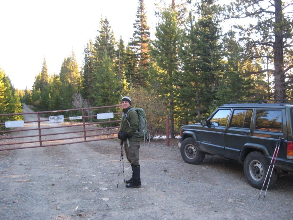 Derek at the gate closure on Aquaduct Rd. (Photo by Greenhouseguy) We started on up the road past the gate for approximately another 50 yards to the split with the Wheeler Trail. The Wheeler trail runs almost parallel to the road except for a slight westward slant that allows for quicker elevation gain towards the lakes in the basin. After 15-20 minutes on the trail, we dropped and crossed a creek which was just before the Wheeler Trail intersection with the Crystal Lakes Road. We took a left (west) turn on the road, and began the final ascent to Lower Crystal Lake. A major portion of the road was under water, and some slick ice almost put me on my butt more than once.  Creek crossing. (Photo taken later in the day.) 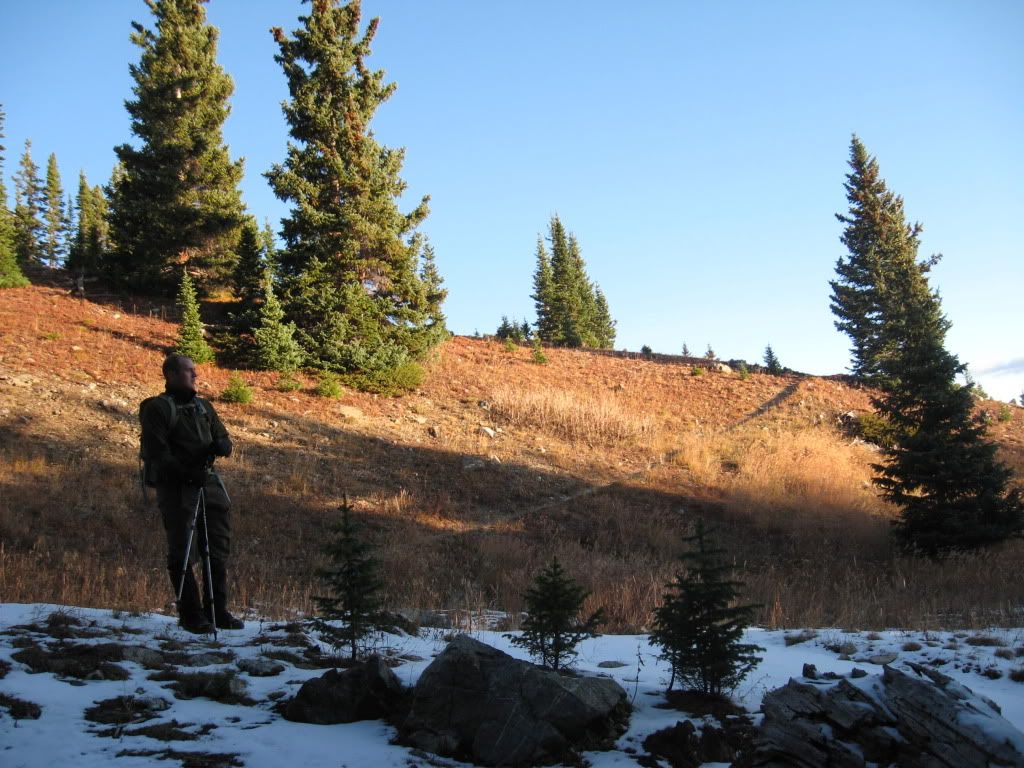 Just past the stream crossing on the Wheeler Trail. The Crystal Lakes Road is just over the ridge pictured. (Photo by Greenhouseguy)  A view west from the intersection of Wheeler Trail and Crystal Lakes Road. Father Dyer is prominent on the left, Crystal is center background. 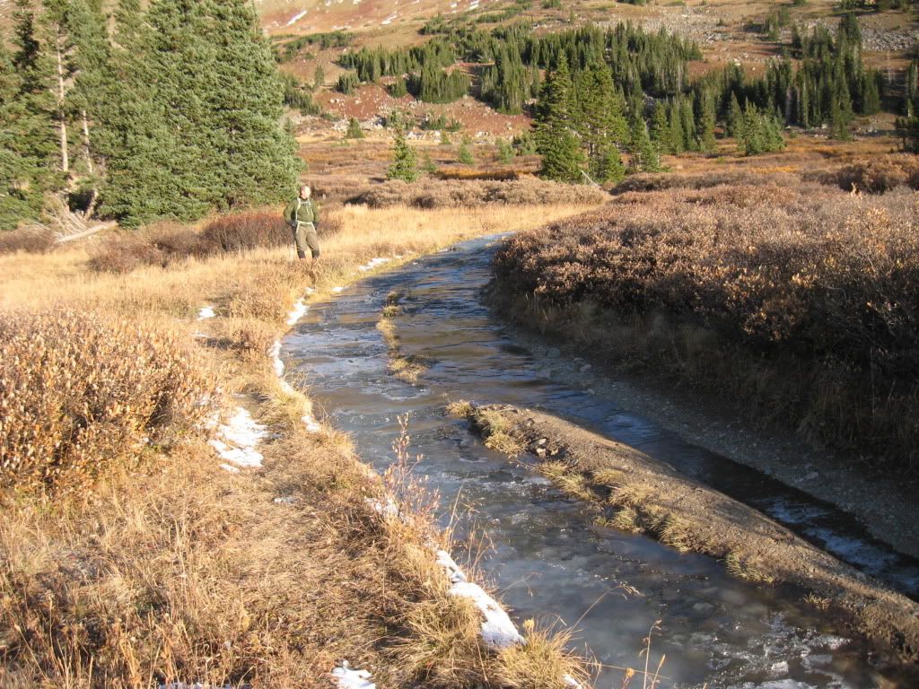 A very icy road. (Photo by Greenhouseguy) We reached the lower lake and had a good view of the surrounding peaks and our route for the day. As I had planned earlier, we took a good look at the ridge leading up to Father Dyer to decide our next steps. Surprisingly, the ridge looked very dry from where we stood. Good enough for us. We broke off from the standard east route of Crystal and followed a mining road SW towards the base of the Father Dyer's NE ridge.  Just shy of the Lower Crystal Lake, Father Dyer pictured, cabin remains to the right of the 4x4 road. Following this mining road SW was steep enough to really work the legs, and I could already tell at this point that I was having a "low energy day". The road portion was short, and as the road turned further to the east we broke off right near the base of Father Dyers ridge.  Base of Father Dyers ridge on the right, our path followed the gulley up and around behind the ridge. Even though at this point we were standing at the beginning of the ridge, there is not a good access point to gain the ridge from this angle. A continued southwest slant is needed, and this leads the climber to a flat(ish) area between the Mt. Helen/Father Dyer ridge to the south and the Father Dyer NE ridge to the north. When viewing the ridge from this angle, a steep and grassy ramp allows easy (but lung busting) access to the top of the NE ridge.  On the grass ramp leading up to the ridge. Father Dyers true summit is the point to the left. After reaching the top of the ridge, we took a quick breather and stowed our poles to get ready for the scrambling ahead. The weather was still remaining perfect, not much wind and steadily warming temperatures.  Looking ahead at some of the initial difficulties. The entire ridge was a constant mix of class 2 and 3, with occasional exposure to both sides. I can recall 2 portions that required my attention. The first was about halfway up and required a careful mini-catwalk across maybe 10 feet of rock. The hardest part of this area was the end of the above mentioned "cat-walk" where there was a large rock that required a pass around on the right. There was light snow in this area, so getting around the rock took some time and extra caution with foot placements. The rock felt relatively solid, but like a lot of rock in that area I would not put too much faith in the holds.  Greenhouseguy working his way across the ridge. 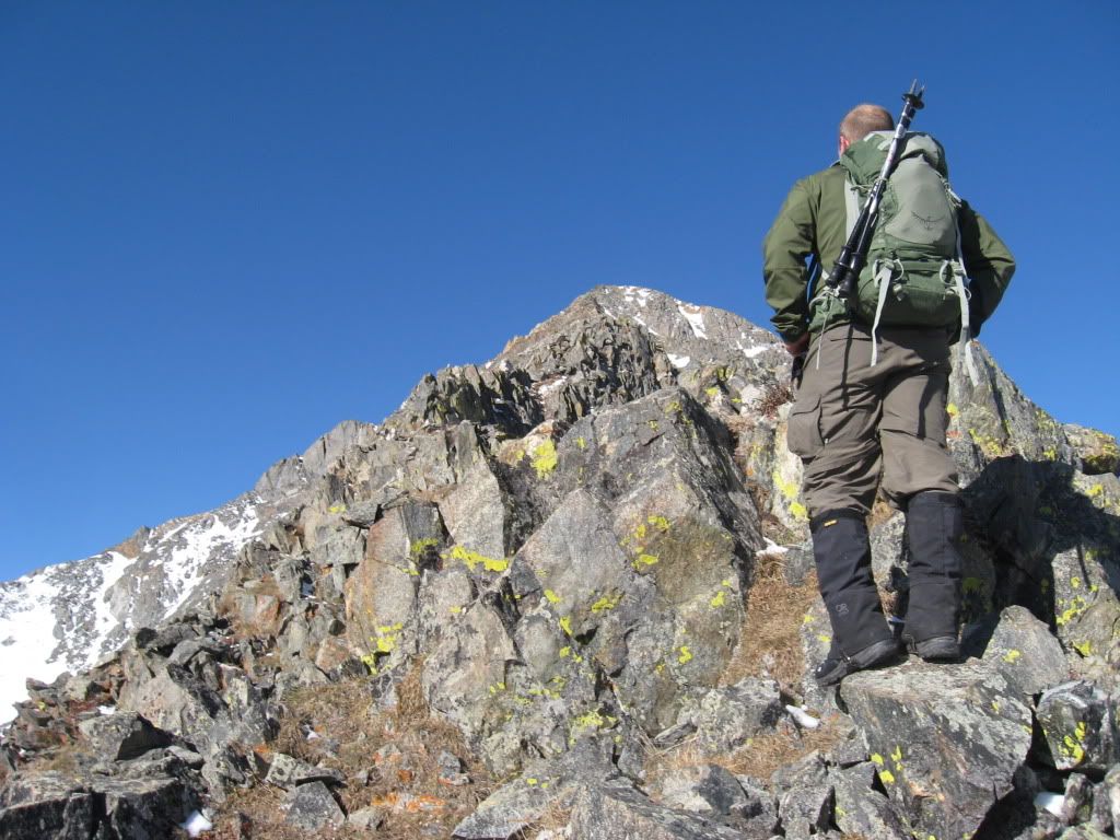 Derek contemplating the next route choices. (Photo by Greenhouseguy)  Greenhouseguy putting his hands to work on one of the higher exposure sections.  What better place to check your GPS? The second attention spot was just a little further up the ridge approximately � of the way up. This spot required the climber to remain directly on top of the ridge, however this portion contained numerous "column rocks". The best way I can describe this area is like walking across lots of logs standing upright at different angles and heights. The mixture of exposure plus strange moves required to cross this section made this portion of the ridge seem harder than it probably was. Walking across the "upright logs". 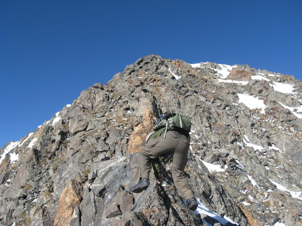 One of the mini knife edge spots, along with a closeup of my butt. (Photo by Greenhouseguy)  Greenhouseguy almost to the top of the ridge. Lower Crystal Lake in the background. Soon after these two spots we topped out on Father Dyers false summit which is a few hundred yards east of the true summit. There was only minimal elevation to be gained for the remainder of the distance to the true summit, and we topped out quickly.  Father Dyer's true summit seen from the false summit. Pacific Peak in the background.  Final stretch to the summit of Father Dyer. The summit of Father Dyer had great views of the surrounding peaks, and although unranked, the summit had a very "summity" feel to it. There was a broken register tube with no register, so we just hung around for a couple minutes before descending down towards the Father Dyer/Crystal Peak saddle.  The full ridge that we ascended viewed from the summit. The grassy ramp we used to gain the ridge can be seen at the bottom.  Plaque located on the summit.  Derek on the summit. A portion of Pacific's East Ridge route in the foreground, Quandary in the background. (Photo by Greenhouseguy) 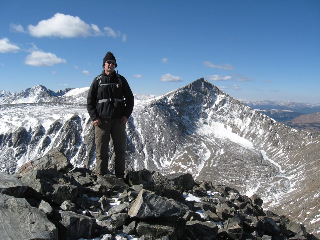 Greenhouseguy on the summit with Pacific in the background.  L to R: Quandary, Democrat, Fletcher, Atlantic, Pacific. The trip to the saddle was slow going and careful attention was needed to foot placement to avoid rolling an ankle. This portion reminded me a lot of the west ridge of Atlantic Peak that Greenhouseguy and I had summited a few weeks prior. Once reaching the saddle, the going got easier with regards to the terrain.  Crystal Peak from near its saddle with Father Dyer.  Looking back at Father Dyer from the ridge to Crystal Peak.  More panoramic fun! I am unsure whether there was a trail up to the summit after the saddle, but the easiest way seemed to just head straight up the southeast side of Crystal Peak. Despite my continuing low energy, the ascent from the saddle to the summit of Crystal seemed to go very quick. 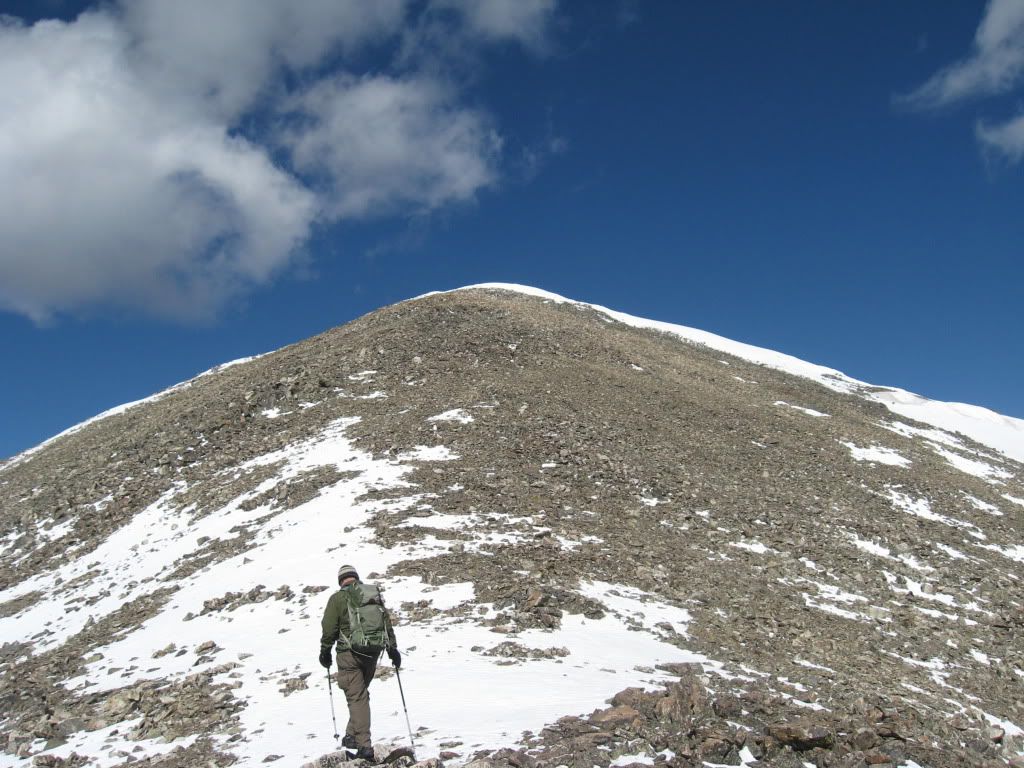 Derek starting the ascent to Crystal Peak. (Photo by Greenhouseguy) It did not appear that anyone had been on the summit of Crystal Peak since the last snowfall, as there were no tracks to be seen. The register was under a bit of snow, so I didn't bother trying to dig it out. Greenhouseguy said that when he was here last month there was no writing utensil in the register anyway. It felt great to finally summit Crystal Peak, but we didn't hang around too long because we wanted to make sure we had a chance to get our bonus peak in on the way out.  Greenhouseguy and Peak 10 from the summit of Crystal Peak. We descended from Crystal's summit to the saddle connecting it with Peak 10. This art of our route followed the standard route for Crystal from the east. We did not find a trail, and again we had to take our time making our way down due to snowy and loose rocks. For someone like me who has bad ankles, these parts always make me tense. It was also tough watching foot placements when the views to the south were so great. We reached the saddle of Crystal and Peak 10 and again left the standard route of Crystal. (The standard route drops down from the saddle at this point.) We began to make our way up the west side of Peak 10.  Looking back at Crystal Peak from its saddle with Peak 10. Soon after ascending towards Peak 10 from its saddle with Crystal Peak we reached a little section that required some harder than normal hiking. Hands were needed, however I wouldn't go so far to say it was anything harder than class 2+. After this quick portion, the remainder of the distance to the summit was smooth (but slow) sailing. Greenhouseguy reached the summit first, and my energy lacking butt made it up a couple minutes afterward. 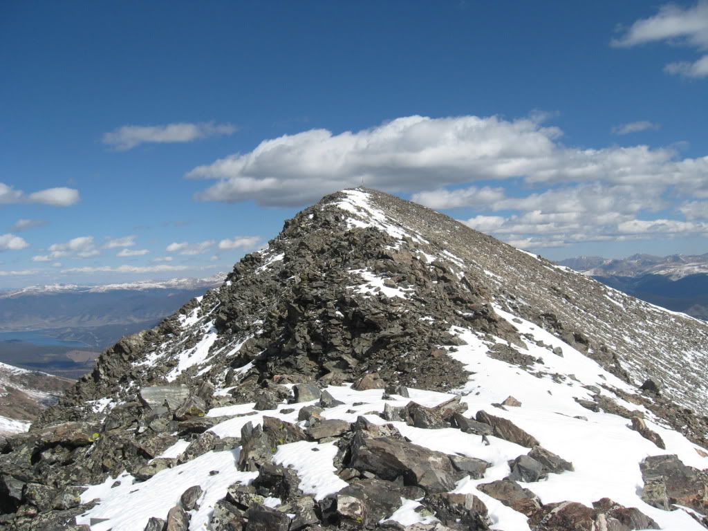 On the ridge up to Peak 10. (Photo by Greenhouseguy) The summit of Peak 10 had a large pole sticking out of it, and strapped to this pole were a number of ski poles, a disintegrated flag, and even a single running shoe. Odd. To the north we could see the chain of mountains including Peak 9, Peak 8, etc. To the west was Crystal from which we had just come. To the south was a large cluster of close-by peaks including Father Dyer, Helen, Quandary, Fletcher, and pretty much the entire Ten Mile/Mosquito range.  Greenhouseguy waiting on the summit.  Derek on the summit of Peak 10. (Photo by Greenhouseguy) After enjoying our third summit of the day, we continued east down the broad ridge of Peak 10. We knew from our maps that by following the ridge out and down, we would eventually run into the Wheeler Trail. The upper portions of the rounded ridge had quite a bit of snow, and it was a lot of fun heel stepping and sliding down.  Looking back towards Peak 10 on the way down. After we made it down past the snowy portions, we could see some wooden poles crossing the grassy ridge below us that marked the Wheeler Trail. At this point we knew that the remaining hike would be quick, so we decided to take a break and re-layer because the weather was turning out to be just fantastic. It almost felt summery, and I enjoyed a few minutes stretched out on the grass taking in the views around me.  Looking over at Father Dyer from the descent. We began our ascent of Father Dyers ridge just above the lake pictured in the middle. (Lower Crystal Lake) The ridge in the background is the Mt Helen/Father Dyer ridge. After lounging for a few minutes, we eventually made our way over the remaining portion of the ridge to the Wheeler Trail, and followed this trail back down to Crystal Creek. After 30 minutes or so, we came to the Crystal Lakes Road that we had turned onto earlier that morning. This completed the full loop for our day. We remained on the Wheeler Trail as it reentered the trees heading back towards the base of Mt. Helen and the Aquaduct Road. 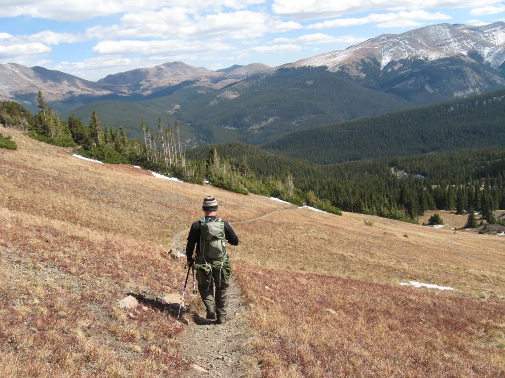 Derek working his way down Wheeler Trail from Peak 10's ridge. (Photo by Greenhouseguy)  Greenhouseguy taking a stop with Peak 10 in the background.  Final look at Father Dyer and the NE ridge.  Views from along the Wheeler Trail.  Intersection of Cystal Lakes Road and Wheeler Trail that completed our loop. Evidently, the Aquaduct road is popular for mountain bikers. Soon after reaching the road we encountered quite a few of them making there way up towards the Crystal Lake road. We reached Greenhouseguy's vehicle quickly after reaching the road. 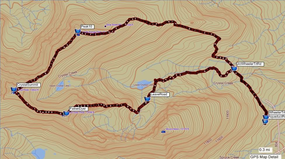 Final track of our route. (GPS track courtesy of Greenhouseguy) This ended up being a great loop hike in absolutely fantastic fall weather. I truly plan on revisiting Father Dyer again in the future to see what other treats it has in store, mainly the ridge from Helen to Father Dyer. Cheers! |
| Comments or Questions | |||||||||||||||
|---|---|---|---|---|---|---|---|---|---|---|---|---|---|---|---|
|
Caution: The information contained in this report may not be accurate and should not be the only resource used in preparation for your climb. Failure to have the necessary experience, physical conditioning, supplies or equipment can result in injury or death. 14ers.com and the author(s) of this report provide no warranties, either express or implied, that the information provided is accurate or reliable. By using the information provided, you agree to indemnify and hold harmless 14ers.com and the report author(s) with respect to any claims and demands against them, including any attorney fees and expenses. Please read the 14ers.com Safety and Disclaimer pages for more information.


