Download Agreement, Release, and Acknowledgement of Risk:
You (the person requesting this file download) fully understand mountain climbing ("Activity") involves risks and dangers of serious bodily injury, including permanent disability, paralysis, and death ("Risks") and you fully accept and assume all such risks and all responsibility for losses, costs, and damages you incur as a result of your participation in this Activity.
You acknowledge that information in the file you have chosen to download may not be accurate and may contain errors. You agree to assume all risks when using this information and agree to release and discharge 14ers.com, 14ers Inc. and the author(s) of such information (collectively, the "Released Parties").
You hereby discharge the Released Parties from all damages, actions, claims and liabilities of any nature, specifically including, but not limited to, damages, actions, claims and liabilities arising from or related to the negligence of the Released Parties. You further agree to indemnify, hold harmless and defend 14ers.com, 14ers Inc. and each of the other Released Parties from and against any loss, damage, liability and expense, including costs and attorney fees, incurred by 14ers.com, 14ers Inc. or any of the other Released Parties as a result of you using information provided on the 14ers.com or 14ers Inc. websites.
You have read this agreement, fully understand its terms and intend it to be a complete and unconditional release of all liability to the greatest extent allowed by law and agree that if any portion of this agreement is held to be invalid the balance, notwithstanding, shall continue in full force and effect.
By clicking "OK" you agree to these terms. If you DO NOT agree, click "Cancel"...
Overview
I'd been wanting to apply an XC ski strategy to shorten winter climb times on day trips, and open up longer routes not ordinarily done in a day due to unplowed roads. The plan would be to use a medley of XC and tele gear: Nordic wax, kicker-stickers, narrow style alpine skis, 75mm bindings, and leather or plastic tele boots, depending on conditions.
Planning
My partner and I needed Humboldt; South Colony Road seemed like a good prospect for employing the strategy. There was little information on winter ascents and current conditions for this mountain, and there appeared to be potential avalanche hazard depending on route selection. At the least it would be a long day. We were all set to go, but he had to bail due to family obligations. Given the unknowns, and the questionable weather, I posted for a partner.
Glen had Tuesday off, but not till 7am. A storm was coming in that night, so waiting one more day was not an option. This would put him at the TH at 10:30. I didn't want to go without at least a reasonable shot at making the summit. A 10:30 start and lots of unknowns put it on the back burner. Then SarahT posted that they had put in a track to Columbia. Glen needed Columbia, it had a long ski-able road in, and it was an hour and a half closer; a summit was possible.
We met at the TH and got rolling at 9:30 am. We both had headlamps. Only kicker was, we were at the tail end of the weather window, with a 20% chance of snow after 11am on that incoming front, and 70% chance of snow that night - so we really needed to be out that evening; no epics, no bivy, no errors.
Theory: The Strategy
The light-and-fast winter strategy called for making a speedy ascent on roads and creek beds, kicking and gliding with Nordic wax on narrower alpine skis and free heels. We would not carry snowshoes. For steeper sections, using "kicker stickers," half-length skins that go under the kicker section of the ski, would provide traction, still allowing for some forward glide on flatter terrain. Two sets of kicker stickers could be put together, when needed, tip to tail, for wall to wall carpeting.
Boots for above-treeline dry sections would be more secure and faster than tele boots. A lightweight, waterproof/breathable insulated boot, the Solomon Softshell Dry, weighs 2 � pounds per pair and works well in winter. Micro-spikes add another 14 oz.
We would not carry skis, ski boots, or snowshoes at any time on the pack, either up or down. On the descent, the XC wax for those little uphill sections on roads and through creek beds would keep us moving. We figured up to 15 mph gliding along roads and creek beds. For this trip, -1 to -8 degree wax, applied to a wide kicker area, before starting, was perfect, and required no downtime for on-route re-application.
Experiment: Mt Columbia
We made our first waypoint, the summer TH, in under an hour, or better than 3 mph, over the 3-mile and nearly 1000-vertical section. We made our second waypoint, about 4.5 miles in, and another 500 vertical, in the next half hour. This put us squarely on course to reach treeline, another 2.5 miles and 1200 vertical, where we planned to drop the skis, by 2.5 hours into the trip, right at Noon. Staying the course had us summitting by 1:30 pm. With those sticks waiting for us back down at treeline, with plans to make 11's back to the car, we were still in the game at this point.
Winter Mistakes
The first mistake became apparent when the Horn Fork drainage got a little steep for the kicker-stickers: I'd left the second pair at the car, so couldn't go tip to tail with skins. I'd already sent Glen on ahead (he had his full length skins on) when putting on the kickers, figuring we didn't have time to lose, and I'd catch up.
The second mistake was not taking the time to pull out the map. Had I done so, I'd have seen that this steeper section was short, and was followed by more flat terrain.
The third mistake was not to at least consider taking the time re-wax tip to tail. This could have been done before starting, as there would be little downside in having a fully waxed base. Wax + kicker-sticker = full length skins, or nearly so.
The fourth mistake was the major one: I assumed the packed trench, which was solid for walking on right there, would be solid the rest of the way up. On this assumption, I ditched the skis. Not 200 yards later the trail became flat again.
The fifth mistake was failure to simply admit to the first four mistakes, and go back and get the skis. Obstinacy begets complexity.
Soon that seasonal disease known as micropostholitis began to set in. Now even further from my PFD's (Personal Floatation Devices), symptoms gave way to serious signs of megalopostholitis. The sinking realization became apparent that if the storm were to come in, and the tracks were covered and lost, I'd essentially be immobilized in a sea of crotch-deep quick-sugar. It wouldn't necessarily get any better after a night's bivy, either.
At such times, one begins to wonder if Nature senses stupidity, and descends with surgical exactness to extract a toll equal to, and bearing an uncanny reflection upon, the size and character of the mistakes of the obstinate.
The Summit: Salacity vs. Sensibility
Mother Nature decided to be sweet today. I caught up with Glen. He was concerned about the time. I felt that if we could make treeline by 1:30, we could easily be back below treeline before dark. This brilliant idea sank quicker than my bare boots through sugar snow.
We did make treeline by 1:30, and were standing under a snowless line all the way up to the summit ridge, in bright daylight. We had 2200 vertical and 1.7 miles to achieve the summit. I was certain we could be back at this spot before sunset, and into the trees before nightfall. The look on Glen's face was not encouraging.
I turned from Glen's gaze and looked to the ridge with shameless lust. After all that work, we finally attained this sacred brown ground. I wanted this summit! Here, we could finally put it in gear, burn some oxygen, apply some torque, and experience the rapture of the steep. I began to perspire with desire, craving that endogenous morphine fix that would put us on this thing we call "The Summit." . Bargaining ensued.
"Glen, look, we've both got headlamps. We can take our time getting back. The sun is still out. The storm is delayed..." As I spoke, the wind began to gust so hard that my words flew away like tissue paper....falling impotently upon the distant forest below...
And then, as if prophetically, Glen slowly turned, and uttered his sole response: "I'm not feeling it, Jim." At that moment, I saw in Glen's eyes the reflection of future events gone afoul. And I heard in his words the voice of reason.
Now, SarahT's party had dug a nice pit and wall at treeline. Glen offered to head over there, shovel a little more, cook some lunch, and wait for me to get back from the summit, if I were still intent on going. He was even willing to go back in the dark, something he really disdained, so that his driven partner could summit. I didn't want to get separated. But Glen's offer was the most gentle, generous, and formidable argument against potential further mistakes. Not to mention sitting in the cold, waiting, for two or three hours...this was generosity so extreme that one could not possibly accept. The restless, petulant fever for the summit push was over. We made the decision to descend. We could now hear the roar of the winds above us, as if saying, "Come back another day; I will be here."
The Descent: Further Strategy Assessment
I'd almost forgotten about the postholing on the way up. Why is it that it's always worse coming back down? After humoring me a tad, Glen skied merrily along and disappeared, leaving me with a painful reminder of mistakes one, two, three, four, and five. Maybe next time I'll think twice before parting ways with my floaters in the winter backcountry.
After a painfully long in-depth exploration of all the hard and soft snow on the trail, I arrived at a pair of skis parked in the snow, a pair of boots hanging in a tree, and a happy partner with a steaming pot of Ramen noodles.
Now, I have to say, the strategy worked very nicely once it was re-deployed. Glen had professed not to be a much of a skier (I beg to differ,) though I think Glen is a believer in the strategy. After packing up, we got down in a hurry - an hour out of the Horn Fork Basin to the winter TH. It was a most effective way to travel, particularly on that last three miles of unplowed road. We were tired, but it wasn't too tough to stand on top of a pair of micro-sleds and let gravity do the work. The Nordic wax was indispensable for keeping speed with all those little uphill sections on the descent.
We were treated to a colorful sunset, and hung around at the cars and talked till after dark. All in all, we could see that with some modifications, this was going to be a pretty good human-powered way to get to winter 14ers that were otherwise precluded by lengthy snow-covered roads. Glen whipped out his electronic work calendar, and as I watched its glow emanating in the dark, we started plotting the sequel...
Current Conditions on Columbia
The winter TH is 3 miles below the summer TH, at about 9050 vertical. We had to park 100 yards before the winter TH because the snow was firm breakable crust, and almost stuck the 4wd.
The first three miles, from parking to the summer TH, has maybe 4-8" of hard snow. It was icy at late day. There are some bare spots forming. The area from the summer TH to the bridge was good snow with a packed track in place, and a ski track. One short area was steep side-hill on firm snow. Other than this, it was straightforward.
We encountered no cracking or settling of snow on the ascent through Cottonwood and Horn Fork, though we stayed on the existing trench. Once or twice I veered off of it, and noted some settling.
After turning north into the Horn Fork basin, the ski track quit, but the snowshoe track provided a well-packed surface. We presumed this was the efforts of SarahT's party, though we did find remnants of earlier efforts. About � mile beyond the north turn, the trail steepens briefly, but then gets flatter again.
Near treeline the winds were blowing snow into the existing tracks and had them completely covered over on our way back. Tracks were preserved in the trees.
The area above treeline on the standard west approach had some snow on it, but as you can see in the photos, there is a nice line the line that was completely wind-scoured, snowless, and presented little avalanche hazard. Summer conditions prevailed higher up.
Overall snow depth in the trees averaged about 2.5 to 3.5 feet in the Horn Fork, and 1 to 1.5 feet in the N Cottonwood Creek drainage. There was accessible running water in the lower drainage, and halfway up the upper basin.
There were some nice, flatter areas for winter camps in the upper basin near treeline. We felt there was little avalanche hazard at any point along the route.
Not much room for parking at the turnaround 100 feet below the winter TH. It looks like a residential lot. We parked as far to the west of this area as possible to minimize impact. There are homes nearby, so please try to be quiet when arriving early or packing up late.
The road between winter and summer trailheads:
. . . . . .
. . . . . .
Aspen shadows along the road:
Along the section from the summer TH to the Horn Fork:
Glen approaches the bridge across Cottonwood Creek, as we turn north into the Horn Fork basin:
. . . . . . . .
The upper Horn Fork Basin in winter:
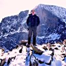
The Ascent party:
The line:
The descent:
. . .
.
. . . . . . .
Thanks to Quaggy and SarahT for last minute info on the Sawatch and the Horn Fork Basin, and thanks to Glen for his gentle sensibility and solid partnership.
Post Script: Stay tuned for the January 9, 2010 sequel...
--Jim
Thumbnails for uploaded photos (click to open slideshow):
Very well written and great pictures! I can‘t wait for the sequel where you make the top. I did the Southeast Ridge today, so my report is likely to follow your sequel (although not as well written).
Slynn, thanks, and be safe on the return...forecasts call for 35 degrees today at 13,600 feet, and 1-3 inches new on Thursday ... snow on ice ... so please be careful... Take care, have a great trip, and send photos!! : ) Let‘s climb when you guys get back.
Kimo -- yes, you know I‘m a fool for aerobic suffering...but got to enjoy aerobic penitance on that SW rib in the high pressure warmth... TR in progress. : ) Shoot me a PM -- let‘s climb soon.
Yog -- We‘re thinking alike. I may be looking at a fun round-trip route up the SW rib, summit, and then back down the SE ridge. Especially now that Quaggy has graciously offered to plow for us. : )
on sticking to your guns and going back to tag Columbia. Obstinacy begets complexity Nice! I like this
Finally got around to read this.
Very nice decision-making, Jim in turning around with Glen. One thing in summer you know, to keep going on while your partner waits but prolly not to prudent in winter. Plus I‘m sure that Ramen tasted good!
It‘s been an age since I‘ve been up in Horn Fork Basin but I remember it being a place of extrodinary beauty. Having the trail packed like that, I think I need to get up there soon & take advantage of the packed trail. Good Aspen shots. I like the one of Glen sitting on the tailgate as well. Good narration! I like the medical references
.
I‘m sure that if I were to have gone on to the summit,
Glen would have looked at me like Blondie (Clint Eastwood)
when he shows up and joins Tuco (Eli Wallach)
to go after a half dozen gunslingers, in The Good The Bad and The Ugly:
Jim - story well told. I like this section: I turned from Glen's gaze and looked to the ridge with shameless lust. After all that work, we finally attained this sacred brown ground...we could finally put it in gear, burn some oxygen, apply some torque, and experience the rapture of the steep. I began to perspire with desire, craving that endogenous morphine fix...
Well written report! I made an attempt on the 10th, but my plan was to catch the south ridge to the east ridge (diverting NW through the basin after the summer TH). Made it to the summer TH in 1 hr 40 min, but after that, the bushwhacking begain and slowed down considerably when hitting the nasty, slippery conditions gaining the S ridge. Time constraints when I was just below treeline on the ridge at about 1:00.
Quaggy - I'm interested in your ridge trip - where did you pick up the ridge? I'm thinking my second attempt will follow the Colorado trail a mile up from Winter road closure (I believe the CT heads up and over the lower portion of this ridge). I think gaining & following the ridge further east, and avoiding the slippery nightmare that attaining the ridge further up the basin entailed could make the ridge route work. Need to research this more. Look forward to your report!
when climbing partners decide to stick together. Congrats on getting it the second time though. Hopefully Glen and I can get it when we go up there in a few days. Nice pictures!
It was good to climb with you Jim, I know we could of reached the summit if we would of went for it, and I am thankfull that we stayed together. All in all not a waist at all. I learn something new everytime I go to the mountains.
Caution: The information contained in this report may not be accurate and should not be the only resource used in preparation for your climb. Failure to have the necessary experience, physical conditioning, supplies or equipment can result in injury or death. 14ers.com and the author(s) of this report provide no warranties, either express or implied, that the information provided is accurate or reliable. By using the information provided, you agree to indemnify and hold harmless 14ers.com and the report author(s) with respect to any claims and demands against them, including any attorney fees and expenses. Please read the 14ers.com Safety and Disclaimer pages for more information.
Please respect private property: 14ers.com supports the rights of private landowners to determine how and by whom their land will be used. In Colorado, it is your responsibility to determine if land is private and to obtain the appropriate permission before entering the property.


")
")
")
")
")
")
")
")
")
")
")
")
")
")
")
")
")
")
")
")
")