Download Agreement, Release, and Acknowledgement of Risk:
You (the person requesting this file download) fully understand mountain climbing ("Activity") involves risks and dangers of serious bodily injury, including permanent disability, paralysis, and death ("Risks") and you fully accept and assume all such risks and all responsibility for losses, costs, and damages you incur as a result of your participation in this Activity.
You acknowledge that information in the file you have chosen to download may not be accurate and may contain errors. You agree to assume all risks when using this information and agree to release and discharge 14ers.com, 14ers Inc. and the author(s) of such information (collectively, the "Released Parties").
You hereby discharge the Released Parties from all damages, actions, claims and liabilities of any nature, specifically including, but not limited to, damages, actions, claims and liabilities arising from or related to the negligence of the Released Parties. You further agree to indemnify, hold harmless and defend 14ers.com, 14ers Inc. and each of the other Released Parties from and against any loss, damage, liability and expense, including costs and attorney fees, incurred by 14ers.com, 14ers Inc. or any of the other Released Parties as a result of you using information provided on the 14ers.com or 14ers Inc. websites.
You have read this agreement, fully understand its terms and intend it to be a complete and unconditional release of all liability to the greatest extent allowed by law and agree that if any portion of this agreement is held to be invalid the balance, notwithstanding, shall continue in full force and effect.
By clicking "OK" you agree to these terms. If you DO NOT agree, click "Cancel"...
Mt. Wilson - My 14er finisher Route: Southwest slope via Kilpacker Basin trailhead Vert: Approx. 4,450 Mileage: 13.4 Time: 5 hours to summit Group: Ben (Benners) & Carl
At the beginning of April I had 13 Sangres and San Juans peaks left on my list of Colorado's 58 14ers. With a little luck and few committed partners, by the first weekend of June, we had managed to ski 12 of these 13 peaks, and I had one 14er left to summit. Unable to squeeze a Mt. Wilson ski descent in this season, the plan quickly came together for a 4th of July trip to Telluride.
Unfortunately, my friend Marc, with whom I had shared more 14er summits than anyone, had a wedding to attend in Seattle this weekend. Marc had been a motivator throughout this 14er project and continues to be a mentor in the mountains. Anyone who knows him wouldn't be too surprised that since he was in Seattle anyway, he climbed Rainer via the Kautz Glacier (with our friend Chris) in a single push from the parking lot the day after the wedding. Congrats guys!
I suppose it was only fitting, however, that I finished the 14ers on Saturday with my good friend Ben. My favorite thing about this website that Bill so selflessly maintains has been the friendships it continues to foster. From the many 14ers.com members with whom I've shared only a carpool and a single summit, to the ones who have become close friends and regular climbing partners. Caroline (USAKeller) introduced me to Ben not too long ago, thinking we might get along well. As we drove down to Telluride this past Friday, Ben and I reminisced about the 25 or so 14ers we've skied together in the last 2 seasons. I guess she was right.
And on to the climb....
With just Mt. Wilson on the agenda, Ben and I opted for the southwest approach from Kilpacker. An inquiry on 14ers.com yielded a useful trip report that included a descent from Wilson into Kilpacker, but with no documented climb on this website of this exact route, we tried to make note of the details during the climb so I could provide them in this TR.
At around 13.5 miles and under 4,500 vertical feet, this route is entirely doable in a day. An excellent camp site exists a few miles in, but it saves less than an hour and a half. With a less than ideal forecast, we left the car at 3:30am. Our approximate route:
About 2.2 miles in, we took the fork to the right, following the sign to El Diente.
Two years ago in Navajo Basin, we almost couldn't leave camp because a mandatory log crossing that was only wet the night before was ice in the morning. Thankfully temps were well above freezing Saturday morning and this log crossing was uneventful.
Me at around 12,500ft as the sun warms the landscape behind us.
A trail leads you below El Diente before it fades in the talus. The route to El Diente weaves its way through the cliff bands before grabbing the ridge east of the summit. Our route to Mt. Wilson continues towards the far side of the Kilpacker Basin before ascending an obvious slope to the north.
Earlier in the year, proceeding on snow directly towards the summit of Mt. Wilson as Roach describes would certainly be the most efficient. We chose to ascend the easy slope pictured below to grab the traverse between El Diente and Mt. Wilson. This gully wasn't too unpleasant, but it is loose and steep enough that in the unlikely event climbers are below you, great caution would need to be exercised.
Ben making the 4th class moves on good rock to reach the ridge.
Ben and El Diente with the sun revealing the portion of the traverse we avoided.
Me on the ridge, pausing to enjoy the views of Wilson Peak and Gladstone.
The remainder of the ridge to Mt. Wilson can be seen here. Our ascent follows the obvious ridge I'm standing on. Our descent follows the less obvious path drawn in yellow.
A hundred feet below the summit we contoured to the northeast side of the ridge. Ben with Lizard Head over his shoulder.
Another great panoramic shot Ben took as I make the final moves to the summit. It's hard to tell here, but there is a huge smile on my face. I'll also add that this was some of the most intense 100 feet of scrambling on any 14er standard route I can recall.
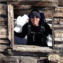
Ben and me on the summit with El Diente in the background.
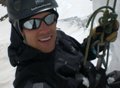
Another summit shot.
For the descent, we chose to downclimb west a hundred feet then proceed southwest to one of the gullies. Ben can correct me if I'm wrong but I recall being able to keep this entirely at class 3. Here is another look at the descent route.
A few hundred vertical of class 3 puts you in one of these gullies. Probably an enjoyable ascent route in late spring snow. Without snow cover the loose rock and scree are a little unpleasant, but not enough to distract from the route overall. As you can tell here, it's not nearly as steep as it looks in that earlier picture taken from the ridge.
I stayed on the snow for the most part on Saturday, but it wasn't very efficient. Hard and fast snow conditions made for a slow and tedious descent. I think I remember hearing laughter as Ben took this shot from the rocks.
Off the moderately steep snow slope and able to relax, I made a quick ascent of this sub summit.
Time to descent, Ben makes fast progress on the snow fields.
Stopped on the way out to take a few classic El Diente waterfall pictures. This one of Ben's turned out pretty nice.
With the exception of a few climbers on the El Diente/Wilson ridge that we noticed in the distance (and later learned to be 14ers.com members), we saw no one the entire day. This fact, together with the scenery that we both agreed was among the best in Colorado, made this an incredible 14er to finish on.
One of my favorite things about deciding to hike and climb Colorado's 14ers is that it forces you to visit parts of Colorado and to travel places when you might otherwise stay close to home. This past weekend was no exception and this trip to Telluride was particularly enjoyable.
Finishing our Mt. Wilson climb around noon left us ample time to take the spouses rock climbing in Ophir.
The Cracked Canyon is a unique place that seemed to have a good selection of easy to moderate trad routes.
Later that day, we found ourselves planning another climb (Dallas) from the pool at the Telluride Mountain Lodge.
Followed by a gondola ride into town for a few celebratory PBRs.
The next day we hiked from the Cross Mountain trailhead and were rewarded with spectacular scenery, and again, had the place to ourselves.
We decided to save a climb of Lizard Head until next year, but we relaxed for a while near there gathering beta, taking photos, and discussing future trips to Lizard, Gladstone, and the Wilsons.
Telluride's fireworks display doesn't disappoint. As the local who gave us chairs and blankets explained, the town has a long history of enjoying their explosives (like many mining towns I suppose).
Made a few stops on the drive home yesterday. The first to grab this picture of Mt. Sneffels
The final stop was to visit the Black Canyon National Park. Definitely worth the detour to see this magnificent canyon that was carved by the Gunnison River flowing up to 12,000cfs. Also some unique climbing to be had on the Painted Wall if you've got the skills and inclination (we were lacking a good deal of the former, and a little of the later).
A parting shot.
Thanks Ben, Al, Denise, and Dayna, for another rewarding 14er climb and amazing weekend playing in Colorado.
Thumbnails for uploaded photos (click to open slideshow):
I remember that log crossing! That and about 8 hours of thunderstorms after summiting Wilson Peak. Congrats on finishing them up. I have just one left, which I should be finishing next month...
Congrats Carl! Strong work this spring on all of those San Juan ski descents too! Way to finish in style with a nice weekend trip as well. I‘m glad we were able to share a few summits together.
Great way to do Mt. Wilson ... and nice to have the wives along for what was a fantastic long weekend for all of you! Beautiful photos ... thanks for posting. (that last photo is hilarious!) Happy trails!
Fantastic TR and photos! This will be very helpful as my husband and I hope to attempt the Mt. Wilson-ED traverse sometime this summer (eek!), and I really appreciate the beta. Congratulations on your finish - very exciting and well-deserved!!
Great way to finish up your first lap of the fourteeners. We were on Mt Wilson Saturday also. We got to the summit ridge just as a group who did the traverse were climbing back off of it. They were the first people we had seen all day doing the standard route! Nice report!
Congratulations on your accomplishment! To me, this report IS the essence of hiking in Colorado. Great friends and loved ones together basking in the beauty and wonder of the mountains. These moments can hardly produce words...and rarely need to.
Thats a nice Tour de Telluride over the long weekend. I guess getting turned back on Wilson a couple years ago was a blessing in disguise. Looks like you fit a little bit of everying in this trip and it shows in your report. Good to see you are already planning some 13er outings.
I‘m sure you remember that icy log crossing I referenced. Some great memories from our trip to the Wilson group. Was telling Ben about it on the drive down.
All the comments are much appreciated. Thanks guys.
Craigo, to answer your question, if you play your cards right, I can only hope that you get something similar (though not exactly the same) as image #24 when you finish. Good luck!
Carl way to finish in style.What a great finisher fun in Telluride with your beautiful spouses and beta for Lizardhead. I just hope you survived the jump on the last picture
Caution: The information contained in this report may not be accurate and should not be the only resource used in preparation for your climb. Failure to have the necessary experience, physical conditioning, supplies or equipment can result in injury or death. 14ers.com and the author(s) of this report provide no warranties, either express or implied, that the information provided is accurate or reliable. By using the information provided, you agree to indemnify and hold harmless 14ers.com and the report author(s) with respect to any claims and demands against them, including any attorney fees and expenses. Please read the 14ers.com Safety and Disclaimer pages for more information.
Please respect private property: 14ers.com supports the rights of private landowners to determine how and by whom their land will be used. In Colorado, it is your responsibility to determine if land is private and to obtain the appropriate permission before entering the property.


")
")
")
")
")
")
")
")
")
")
")
")
")
")
")
")
")
")
")
")
")
")
")
")
")
")
")
")
")
")