Download Agreement, Release, and Acknowledgement of Risk:
You (the person requesting this file download) fully understand mountain climbing ("Activity") involves risks and dangers of serious bodily injury, including permanent disability, paralysis, and death ("Risks") and you fully accept and assume all such risks and all responsibility for losses, costs, and damages you incur as a result of your participation in this Activity.
You acknowledge that information in the file you have chosen to download may not be accurate and may contain errors. You agree to assume all risks when using this information and agree to release and discharge 14ers.com, 14ers Inc. and the author(s) of such information (collectively, the "Released Parties").
You hereby discharge the Released Parties from all damages, actions, claims and liabilities of any nature, specifically including, but not limited to, damages, actions, claims and liabilities arising from or related to the negligence of the Released Parties. You further agree to indemnify, hold harmless and defend 14ers.com, 14ers Inc. and each of the other Released Parties from and against any loss, damage, liability and expense, including costs and attorney fees, incurred by 14ers.com, 14ers Inc. or any of the other Released Parties as a result of you using information provided on the 14ers.com or 14ers Inc. websites.
You have read this agreement, fully understand its terms and intend it to be a complete and unconditional release of all liability to the greatest extent allowed by law and agree that if any portion of this agreement is held to be invalid the balance, notwithstanding, shall continue in full force and effect.
By clicking "OK" you agree to these terms. If you DO NOT agree, click "Cancel"...
"You come here looking for the ride to glory, go back home with a hard-luck story" - Elvis Costello, Radio Sweetheart
I've had Mount Antero near the top of my list for quite some time. Those of you who have slogged up the standard route probably cannot imagine how that could happen unless it were one of my last few. However, I was toying around on the site one day and came across this thread:
Which described a rarely-used route departing from Raspberry Gulch. Being a fan of non-traditional routes, and also a fan of loop hikes, my plan was to ascend via this route, then descend along the Little Browns Creek trail.
I even had a Friday off from work! Two consecutive Fridays, actually - last Friday, there was a 60% chance of thunderstorms on Antero, so I went for Mount Evans instead. Today - no rain anywhere in the forecast. Why is that? Partly because of the 30-35 mph sustained winds in the forecast (with gusts up to 50mph). Surely it couldn't be that bad! But it is Friday the 13th, so...
(Before you go further, Wish I lived in CO happened to post a trip report of this very route while I was hiking it! Talk about your coincidences - one of the reasons I was looking forward to writing this up was because there hadn't been a trip report for this route in four years. Well, Wish's report kicks my report's ass, in terms of details as well as in terms of the fact that he actually summitted. I exhort you to read his report first:
Okay, let's continue now...)
Instead of my eighteenth fourteener summit, here's what actually happened to me:
I made the drive all the way to the road closure in my Ford Ranger, without using 4wd (except to back into my parking spot). The fact that it was dark likely helped, because on the drive back to US-285, I realized that you'd probably want 4wd here - and a high-clearance vehicle (or a bold driving strategy). I didn't bottom out once on the drive up, but hit the ground thrice on the return.
Anyhow, my Friday the 13th adventure began at 6:10 with a continuation along the now-closed road.
The road takes a turn to the right, up the hill to the saddle between Raspberry Mountain and the long eastern extension of Antero. Upon reaching the saddle, the hiker should take a sharp left up the very steep ridge. How steep?
It's consistently like that until you gain the ridge itself (and although I tried my best, the picture doesn't really convey the steepness).
Once you're on the ridge, you must dodge trees, bushes, and loose rocks as you gain elevation to treeline. Your reward? A pretty nice view of the Arkansas Valley:
Mount Princeton to the north:
From here, you can essentially see the entire route ahead. Skirt all summits to climber's left, but continue to ascend. Once the grass ends, it's loose talus. At this point, it's getting exceptionally windy.
And a look into Raspberry Gulch itself:
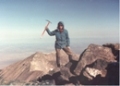
Since there's no summit photo in this trip report, this is the "money shot" - on the saddle between Point 13,105 and Point 13,888, a rare angle of Mount Antero:
The next step - to ascend diagonally up (on climber's left of the ridge) to Point 13,888:
Unfortunately, I would not be taking that journey for very long. The winds had been getting progressively worse and worse. I was starting to rue the fact that I had no goggles (only sunglasses), and was starting to decide how I would get back to Denver if I lost a contact lens (my vision is 20/700 in one eye and 20/850 in the other). As it turns out, that wasn't a problem.
The problem was that, as I crossed from one piece of talus to the next, the wind picked me up (or so it felt), and I tumbled about fifteen feet down the hill. Fortunately, all injuries were cosmetic (although my left knee is somewhat swollen), but it looks pretty gruesome (photo not available )
The thought of being on the ridge between Point 13,888 and Mount Antero, especially with a less-than-fully-functional left leg, gave me pause, and I started to look for a good way down. My solution? Contour around to the south side of Raspberry Gulch, and descend into the drainage towards the trailhead:
Plus it would give me a chance to take some photos of the Raspberry Gulch route from a different vantage. A look back at Point 13,105:
Here's the Raspberry Gulch route. Raspberry Mountain is at far right, and the hiker ascends the saddle just to the left. Then, the hiker rides the ridgetops (going to hiker's left where appropriate):
My descent route looks to be used by more than a few people to climb Antero. There were several distinct (although faint) trails. If one were to ascend in this fashion, here is what Point 13,888 would look like:
It actually looks like that even if one weren't to ascend in this fashion. Go figure.
The saddle between Mount Antero and Mount White. It looks like this descent (per my original plan) would have been quite comfortable.
Instead, I decided to stay on the ridge:
And then drop into one of the drainage gullies towards the Gulch. This descent route was steeper than the ascent route described earlier:
I really shouldn't describe any more of my descent towards the trailhead, lest some fool decide that it's possible. Keep in mind that I, myself, am a fool, and that the alternate title of this trip report was going to be:
"If a Tree Falls in the Forest, and No One Hears, Will It End Up in Doctor No's Descent Gully?"
Here's just one example:
Once you get down to the creek itself, things aren't much better. I'm surprised that there's no trail up into the Gulch itself (not even a faint one). It was more fallen logs, rough bramble, and slick rocks:
But eventually, I made it. Some post-hike photos:
Mount Princeton from CR-270:
Just south of Nathrop, I finally got a modicum of proof as to just how windy it was today:
Mount Princeton from just west of Buena Vista:
Mount Antero from just west of Buena Vista:
Anyhow, I did not summit, but I lived to climb another day. Hopefully this report is useful to someone!
My GPS Tracks on Google Maps (made from a .GPX file upload):
A noble effort, Doctor No, on a very appealing ascent route. The wind must have been brutal. Your descent was gutsy and required strong orienteering skills. Nice work in making it as far as you did under suboptimal conditions. Amazing coincidence to overlap with Wish I Lived in CO's trip on this obscure route! Thanks for posting this interesting and informative report. Climb on, Dude.
Yes, quite the coincidence as 14erFred points out. We should have done this together! Well, congrats on a fine effort that took a turn to some ”air time” and a bruised knee. On the way up I was curious what descending right into the gulch would entail - you've answered that; also the White / Antero saddle you mention seems interesting. I think your descent gulley, along with all it's trees, should be officially named: Doctor No's Gulley! Great report!
Absolutely - when you're next climbing, let me know (especially if you're doing a weird route)! One the day you climbed Antero, we were in RMNP hiking Chapin and Chiquita (a nasty thunderstorm rolled in just as we started on Ypsilon).
We went up the opposite direction from your loop. We tackled the steep ridge south of the CT straight up to the East Ridge above Little Brown. While we didn't think it was so bad, we did wonder if anyone had ever went down this side. The picture of the deadfall pretty much sums up what I thought the creek bottom would look like. The big climb to the ridge at 13,880 was tougher than we thought, and the scramble to summit a lot of fun. Overall, it was a great non standard route!
Caution: The information contained in this report may not be accurate and should not be the only resource used in preparation for your climb. Failure to have the necessary experience, physical conditioning, supplies or equipment can result in injury or death. 14ers.com and the author(s) of this report provide no warranties, either express or implied, that the information provided is accurate or reliable. By using the information provided, you agree to indemnify and hold harmless 14ers.com and the report author(s) with respect to any claims and demands against them, including any attorney fees and expenses. Please read the 14ers.com Safety and Disclaimer pages for more information.
Please respect private property: 14ers.com supports the rights of private landowners to determine how and by whom their land will be used. In Colorado, it is your responsibility to determine if land is private and to obtain the appropriate permission before entering the property.


")
")
")
")
")
")
")
")
")
")
")
")
")
")
")
")
")
")
")
")
")
")
")
")