Download Agreement, Release, and Acknowledgement of Risk:
You (the person requesting this file download) fully understand mountain climbing ("Activity") involves risks and dangers of serious bodily injury, including permanent disability, paralysis, and death ("Risks") and you fully accept and assume all such risks and all responsibility for losses, costs, and damages you incur as a result of your participation in this Activity.
You acknowledge that information in the file you have chosen to download may not be accurate and may contain errors. You agree to assume all risks when using this information and agree to release and discharge 14ers.com, 14ers Inc. and the author(s) of such information (collectively, the "Released Parties").
You hereby discharge the Released Parties from all damages, actions, claims and liabilities of any nature, specifically including, but not limited to, damages, actions, claims and liabilities arising from or related to the negligence of the Released Parties. You further agree to indemnify, hold harmless and defend 14ers.com, 14ers Inc. and each of the other Released Parties from and against any loss, damage, liability and expense, including costs and attorney fees, incurred by 14ers.com, 14ers Inc. or any of the other Released Parties as a result of you using information provided on the 14ers.com or 14ers Inc. websites.
You have read this agreement, fully understand its terms and intend it to be a complete and unconditional release of all liability to the greatest extent allowed by law and agree that if any portion of this agreement is held to be invalid the balance, notwithstanding, shall continue in full force and effect.
By clicking "OK" you agree to these terms. If you DO NOT agree, click "Cancel"...
Four weeks ago I went down to Navajo Basin with two friends to climb the Wilson group. The weather treated us very badly, and I bad mouthed Mother Nature in my trip report. Feeling guilty, I wondered if she would be dishing out any revenge for the rest of the year. As it turns out, I owe her quite an apology. Two weeks ago I got a bluebird day for San Luis and Uncompahgre, and Saturday she gave my friend Ernie and I a great day to get the Wilson traverse. We drove from Denver and got to the Kilpacker trailhead at 11:00 PM on Friday night. Up at 3:00 AM, I had an awful start. Weeks ago my boots had gotten soaked, and I left them in the sun to dry. Too long, as it turned out, because they shrunk and bent, and were incredibly painful on my toes and heels in the parking lot. For a moment, I started to make the tough decision not to climb, but a seven hour drive always gives one some inspiration to try. Hoping they'd stretch out, we started on the trail at 3:35 AM.
Kilpacker to El Diente
My toes were screaming at first, but I was juiced- this would be my finisher if I could suck it up. Before long my shoes stretched out, and we flew to the junction (45 min) and then to the river crossing. Quickly thereafter, the trail turned straight up and the climbing began. I was worried about getting into the basin before dark and not being able to follow the path, but the path was far more worn than expected. We got a few feet off from time to time, but it was well cairned and relatively easy to follow. We stopped to let dawn catch up before making the hard left up the sidewall, but when we did, it was easy to follow. Bill's pictures and the trail & many cairns had us up into the gray gully before long. We were a bit confused at that point, but the route description said we would be, so we figured we were in the right place. From the top of the gray gully, it's pretty easy to see the two notches, one fairly close and one near the ridge, and make out the entire line to traverse. Still, the cairns persisted as well, and the path was easy to follow. Before long, we topped out on the ridge, to a glorious view of Navajo and Wilson Peak. I expected the ridge to be wider, but we quickly jumped over to the right, and were on the final push to El Diente. We summited at 7:50, feeling strong, and enjoyed a sunny twenty five minutes hydrating, eating, and enjoying the views.
My overall impression was this: anyone who goes up Navajo Basin and summits El Diente from the North Slopes is either on serious drugs or enjoys painful self punishment. Four weeks ago we got to 13,400 in that gully before weather turned us back, but it was enough to know I don't want to return to it. Take my advice- come from the south.
First light, looking up the basin toward Mt. Wilson
First sunsplash on El Diente
El Diente from the top of the gray gully
The first notch you'll come to. Lots of notches on El Diente
Wilson Peak, in all its glorious glory, when we topped out on the ridge
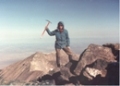
Me, happy, on El Diente- one more to go!
From the summit down toward the trailhead. Can you see our car?
The Traverse
We left the summit at about 8:15, with Wilson on our minds. The first stretch was easy to follow, having just come that way. I had studied the route for weeks, but it's never quite the same as it looks in the pictures, so I tried to prepare myself for anything. After breaking off from the El Diente route, we wondered if the cairns would cease, but they continued. Making our way through the organ pipes was pretty straight forward- maybe a couple class 3 moves, but it felt more 2 or 2+. However, the gendarmes were a bit more than I expected. First, they are an incredible sight- huge and daunting. Even though the cairns led us to the entrance, there were some very awkward, exposed moves along the way. I never felt really unsafe or uncomfortable, but looking at the pictures, I expected more stepping along exposed ledges. There was plenty of that, but also more hand and feet climbing as well.
We stopped before the coxcomb- the crux of the traverse- to study the pictures and pick our line. It looked hairy, but we can't say we didn't know it would come. We started up the thin gully, sticking close together to protect from rockfall, and then exited to the left, which we thought was correct, when it became sheer. There was some serious exposure here, and some very tricky moves. I didn't get that "What the hell am I doing here?" feeling, though, and soon enough we topped out on the ridge. As it turned out, we took the wrong line out of the gully, and made it much harder than we needed. A climber behind us found a cairn on the right that led to an easier exit from the gully. Later, he told us he assumed were some kind of serious rock climbers who were looking for a more difficult challenge going that way. Nope- just clueless route finders. But it worked, and onto the thin ridge.
The thin ridge offered more security than expected, and quite a bit of relief. Happy to have the crux behind us, I enjoyed the view of Wilson Peak bathing in sunlight while I chose my steps carefully, occasionally using three points of contact for safety. Downclimbing to the saddle was tricky because of some fresh snow on some thin ledges we had to traverse, but there were plenty of handholds, and we took a deep breath gaining the saddle.
The notch to the standard Wilson route was obvious, and we were on the summit ridge in minutes. Here, however, the pictures again didn't give justice. The first move looked tough, and we debated going down to the left, but it was just a cliff, so we had no choice. I used both hands to lift myself over a peaked rock, and tore a good sized hole in my pants. Bummer- I loved those pants. The ridge had my attention and kept me hyper aware of all contacts. The second move was the crux of the ridge, but I didn't realize until I topped out and was suddenly there! What an incredible moment- beautiful mountains near and far, a sun soaked summit. My last 14er. We sat for quite a while enjoying it all, eating trail mix, content and happy.
Past the organ pipes, back at El Diente
Back at the gendarmes
Look what I climbed!
Nearing the coxcomb, the sun still low over Mt Wilson
On top of the coxcomb, the rest of the traverse ahead
Looking back at the entire traverse
Me, the traverse behind
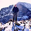
A happy finisher, Wilson Peak behind
The Exit into Kilpacker
We studied our exit off Mt Wilson as we moved closer along the traverse. I thought there might be a doable gully from the saddle after the coxcomb, but it cliffed out. We located the gully on the west side of Wilson we had seen in recent trip reports, and planned our escape. On the summit, we met another climber who had the same plans as us, and we joined up. From the top, there is a pretty obvious gully just to the south, which was easy to reach- maybe class 2+ or easy class 3. It was loose talus in the gully without any real trail, but I would call it "pain in the butt" class 2. We slid down for a while, and when we saw it cliff out down below, we crossed a rib to the next gully over to our right. Class three downclimbing into the gully, but then more of the same steep, loose scree- unpleasant but not hard climbing. When things got a little steeper, we crossed over one more time to the next gully on the right and found our way, but either would have worked. My advice if you're coming this way is get in the main gully seen easily from the summit, and continue to work to the right whenever things start to look rough. We were spilling out into the basin before long.
The main gully from the summit:
In the main gully
About to cliff out
Exit to the right here at this rib
Into the basin, looking back up at Mt Wilson
The walk out
As happy as I was, and as well as the day had gone, I was about to start to pay for it. Walking downhill was jamming my toes into the end of my shrunken boots, and I was miserable. Worse, we were on some of the most unpleasant talus I've encountered- loose, small, and sharp. I limped down going so slowly, feeling it on each step. Eventually, we got to the Kilpacker path, and I put on running shoes I had thrown into my pack, which helped out a lot. On the walk out, I thought of a lot of people I've climbed with who I wished could have been here with me- Wendy, my kids, my mom, Laura, Derek, Janelle, Matt, and several others. As always, I thought about Talus Monkey, who had once summited these peaks as well.
El Diente with the waterfall
The lower waterfall
El Diente from a meadow along the way
"The Dentist", as Matt would say
Finally the parking lot appeared across a meadow, and I was off to meet up with my wife in Buena Vista to celebrate the final two. We sat at the Eddyline Brewpub drinking beer and eating burgers and queso before going back to the hot tub at our bed & breakfast. A day that started at 3:00 AM was coming to a very happy end.
Edited to add three pictures Ernie took and sent:
"Which way to the top?"
Climbing a boulder field
Relaxing, enjoying #58
Thumbnails for uploaded photos (click to open slideshow):
We hiked the traverse later than same day, from Navajo Lake, up the north buttress. We heard and saw massive rockfall happening on the North Slopes, and were extremely thankful not to be on that route. I agree with your assessment of that potentially dangerous route. The north buttress on the other hand was pretty solid.
We were both part of Reno Bob's Culebra climb in August 2008. The Dem convention was being held in Denver at the same time and I remember how anxious you were to get the text message identifying Obama's running mate! Somehow that seems like a long time ago. You have been busy climbing since then, uh? Another great trip report with helpful beta. Keep smiling.
JS: Beautiful work in pulling off this classic route. You couldn't pick a better finisher -- congratulations on climbing all 58! You've got more mountains to climb in the classroom, I'm sure. Onward and upward...
NOW who am I going to complain to? 9/7/2010 3:12am
Congratulations! And as always a supremely entertaining report. Dentists can be very scary, Marathon Man, the Big Book of British Smiles, you should have been a lot more scared@#*!
Caution: The information contained in this report may not be accurate and should not be the only resource used in preparation for your climb. Failure to have the necessary experience, physical conditioning, supplies or equipment can result in injury or death. 14ers.com and the author(s) of this report provide no warranties, either express or implied, that the information provided is accurate or reliable. By using the information provided, you agree to indemnify and hold harmless 14ers.com and the report author(s) with respect to any claims and demands against them, including any attorney fees and expenses. Please read the 14ers.com Safety and Disclaimer pages for more information.
Please respect private property: 14ers.com supports the rights of private landowners to determine how and by whom their land will be used. In Colorado, it is your responsibility to determine if land is private and to obtain the appropriate permission before entering the property.


")
")
")
")
")
")
")
")
")
")
")
")
")
")
")
")
")
")
")
")
")
")
")
")
")
")
")