Download Agreement, Release, and Acknowledgement of Risk:
You (the person requesting this file download) fully understand mountain climbing ("Activity") involves risks and dangers of serious bodily injury, including permanent disability, paralysis, and death ("Risks") and you fully accept and assume all such risks and all responsibility for losses, costs, and damages you incur as a result of your participation in this Activity.
You acknowledge that information in the file you have chosen to download may not be accurate and may contain errors. You agree to assume all risks when using this information and agree to release and discharge 14ers.com, 14ers Inc. and the author(s) of such information (collectively, the "Released Parties").
You hereby discharge the Released Parties from all damages, actions, claims and liabilities of any nature, specifically including, but not limited to, damages, actions, claims and liabilities arising from or related to the negligence of the Released Parties. You further agree to indemnify, hold harmless and defend 14ers.com, 14ers Inc. and each of the other Released Parties from and against any loss, damage, liability and expense, including costs and attorney fees, incurred by 14ers.com, 14ers Inc. or any of the other Released Parties as a result of you using information provided on the 14ers.com or 14ers Inc. websites.
You have read this agreement, fully understand its terms and intend it to be a complete and unconditional release of all liability to the greatest extent allowed by law and agree that if any portion of this agreement is held to be invalid the balance, notwithstanding, shall continue in full force and effect.
By clicking "OK" you agree to these terms. If you DO NOT agree, click "Cancel"...
Peak(s):
Badger Mountain - 11294
South Tarryall Peak - 11206
Party: Jason solo
Vert Gain: ~ 4700' (S. Tarryall - 2766; Badger - 2000)
Mileage: ~ 11 miles (S. Tarryall - 9.0; Badger - 2.0)
Times:
Start (Spruce Grove TH): 8:30AM
Summit S. Tarryall Peak (via Hankins Pass & then bushwack to summit): 10:30 AM
Leave Summit: 11:00AM
Back to Spruce Grove TH (via the west face which offered some Class 3): 12:30PM
Start (pulloff � mile below Wilkerson Pass off Hwy 24): 1:30PM
Summit Badger Mountain (via the south face): 3:00 PM
Leave Summit: 3:15PM
Back to car: 4:15PM
The stars were aligned Saturday for some late season peak bagging before the onset of winter. With the wife & kiddos out of town visiting family, great weather conditions and little/no snow in the Lost Creek Wilderness (LCW) it was a good day to take a break from a busy work schedule. After an unsuccessful attempt (thwarted due to whiteout conditions) on South Tarryall Peak back in January it was time to take care of some unfinished business. The LCW is a great place for all season hikes, offers outstanding views of the Sawatch & Mosquito Ranges, and has some really cool rock formations as well. I have enjoyed the 2-3 times exploring in the LCW and would highly recommend it. This particular area lies near the southern end of the Hayman burn. Most of the trees coming up 77 Road are intact however you can see where the wind must have blown over a couple ridge lines. For Badger Mountain I actually just hiked along the telephone cut - very steep but fast. As I need to get back to the grind I'll keep it very short and just show some pics.
Spruce Grove TH with South Tarryall Peak in background
Peaceful stream bridge crossing near TH
Trail sign after stream crossing
Cool rock formation
Another cool rock formation coming down the west face
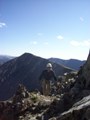
McCurdy Mountain (right) and Bison Peak from summit
Mosquito & Ten Mile Ranges from summit
Summit cross with Sawatch Range in background
Benchmark
Looking down on the TH
View west from Badger Mountain - Antero Reservoir in middle of pic with Mt. Princeton in background
Badger Mountain Benchmark
Radio tower
Thumbnails for uploaded photos (click to open slideshow):
Derek, I was thinking the same about 11053. That was a good day.
Jason, South Tarryall's kind of a neat summit. I think you used the same route I did and if I remember correctly, the view just opens up in the last few feet. I do remember that Pikes Peak looked too close.
The Puma Hills are a unique place, particularly when viewed from above. Great view of Pikes as well. On Saturday they were somewhat obstructed due to a controlled burn taking place south of Hwy 24 near Lake George, which is why I didn't throw up a pic.
I love Puma Hills - I grew up going camping there a TON. Nice photos!
Caution: The information contained in this report may not be accurate and should not be the only resource used in preparation for your climb. Failure to have the necessary experience, physical conditioning, supplies or equipment can result in injury or death. 14ers.com and the author(s) of this report provide no warranties, either express or implied, that the information provided is accurate or reliable. By using the information provided, you agree to indemnify and hold harmless 14ers.com and the report author(s) with respect to any claims and demands against them, including any attorney fees and expenses. Please read the 14ers.com Safety and Disclaimer pages for more information.
Please respect private property: 14ers.com supports the rights of private landowners to determine how and by whom their land will be used. In Colorado, it is your responsibility to determine if land is private and to obtain the appropriate permission before entering the property.


")
")
")
")
")
")
")
")
")
")
")
")
")