Download Agreement, Release, and Acknowledgement of Risk:
You (the person requesting this file download) fully understand mountain climbing ("Activity") involves risks and dangers of serious bodily injury, including permanent disability, paralysis, and death ("Risks") and you fully accept and assume all such risks and all responsibility for losses, costs, and damages you incur as a result of your participation in this Activity.
You acknowledge that information in the file you have chosen to download may not be accurate and may contain errors. You agree to assume all risks when using this information and agree to release and discharge 14ers.com, 14ers Inc. and the author(s) of such information (collectively, the "Released Parties").
You hereby discharge the Released Parties from all damages, actions, claims and liabilities of any nature, specifically including, but not limited to, damages, actions, claims and liabilities arising from or related to the negligence of the Released Parties. You further agree to indemnify, hold harmless and defend 14ers.com, 14ers Inc. and each of the other Released Parties from and against any loss, damage, liability and expense, including costs and attorney fees, incurred by 14ers.com, 14ers Inc. or any of the other Released Parties as a result of you using information provided on the 14ers.com or 14ers Inc. websites.
You have read this agreement, fully understand its terms and intend it to be a complete and unconditional release of all liability to the greatest extent allowed by law and agree that if any portion of this agreement is held to be invalid the balance, notwithstanding, shall continue in full force and effect.
By clicking "OK" you agree to these terms. If you DO NOT agree, click "Cancel"...
This peak offers one of the best 360 views I've yet seen. An the northern end of the Sangre de Cristo's you get a great view of the Sangre's the S Sawatch, the S. Mosquito's and even Pikes Peak.
Climb Stats:
5.1 miles, 3100' gain
Conditions: few inches to a foot of snow (not bad at all), the road was quite passable with a good EXCEPT for a few hills where there was a sheet of ice under the snow.
I was originally planning on hiking closer to home, but as the N. half of the state had a very nasty forecast.I headed S. to the Sangres. After skimming trip reports decided to do Hunts Peak. Driving through S Park on the way there Way nicer near Antero Junction Hunts Pk from Poncha Pass
To get there drive 4.75 miles S of Poncha Pass to a turn off on the left over a cattle guard (thanks to DHatfield trip report for this detail). From here follow the sings to Rock Creek. Up to the crossing of S Rock Creek the road wasn't bad at all. But around the creek crossing there was a sheet of ice under the snow. follow the signs road in the open road in the tress icy spot near the river crossing, basically a controlled slide
Where I have "trailhead" marked on the map is where another road heads up S Rock Creek, the 1st part of the trail actually a pretty rough 4x4 road. I was able to drive up it a little and save me a mile or so round trip (and about 500' in elevation gain). In the summer you could probably get up even further, but there is a large tree in the road (on the map).
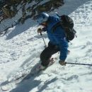
Basically follow the road till a tight switch back and head straight up the hill ~1000' vertical (the road actually continues just a little further but doesn't get you much higher). Its a very steep climb to the ridge, but I don't think there's anyway around it. heading up the hill to the ridge winter wonderland looking down at the ridge
Once on the ridge the remainder of the route is obvious and Hunts Peak is in view (though over 1000' gain still left). Hunts Peak from the Ridge up top
Up to reaching the top of the ridge it was nice enough for me to wear nothing but "fleece" gloves, a soft shell jacket and pants. The ridge itself was quite windy and I needed to add a hard shell jacket and pants and beefer gloves.
The views up top are AMAZING. Pictures are better than I can describe. Hunts Lake Looking N up the Arkansas Valley. Salida Looking S down the Sangres Pikes Peak in the distance Buffalo Peaks (S end of the Mosquito Range) Shavano and Antero Mt Ouray
Driving out I took a different route (to avoid the river crossing), there unfortunately was a bit of ice this way too, and once you are out of the trees there is a lot of social trails to make finding your way out confusing.
My advice driving would be to come in the way I did but stop BEFORE the icy river crossing and leave the way you came. In the summer of course this wouldn't be an issue.
My GPS Tracks on Google Maps (made from a .GPX file upload):
Great stuff - love the pics.
Sounds like an excellent choice with the current conditions.
Spent some time in the Sangres this summer when the monsoon flow was hitting the San Juans and Elks - excellent, often drier, alternative. Agree with you, the northern Sangres are fabulous!
Thanks for posting!
Great pics/route map. Doesn't look as snow covered as I imagined it would in December. Did you see anyone else out on your hike? Just curious how many others are out this time of year...
Cool TR, thanks for posting. I climbed Hunts this summer and was in awe of the views as well. Thinking of a multi-day trip in Sangres next week, conditions look vastly different from the Tenmile/Mosquito.
for all the comments.
Greenhorn: I did not see anyone else on the hike, there were some tire tracks already in the snow on the parts of the road up to the trees, but it the road through the woods was tire track free. I tend not to see anyone on 13er hikes unless its one by a 14er .
Jesse: A multi day in the Sangres is always worth it, one of the most dramatic ranges in the state.
...is deep water in the springtime, especially during the runoff. I clearly remember probing with our poles to make sure we could cross it, and we *barely* squeaked through without soaking the floorboards, or sinking into mud! Just a word of caution for folks venturing out via this route - check it out before you commit to it :-) Great report, and yeah, those views! Looks like you made a great choice and avoided the usual quad-burning trail-breaking that comes with high peaks this time of year.
What a beautiful day you ended up having! We opted to do this peak from the other side of the range (our vehicle could not make the creek crossings) ... your route looks much more direct. Thanks for posting. Happy trails!
Love that shot looking down the SDC range. Beautiful!
It was also neat to see the lake - I used to fish some of the lakes in the Sangre in winter - still have a backpackable ice auger I made for the purpose. I've never drilled the ice on Hunts, but been up there a few times in summer - would love to see under the surface at that deep end - looks like the ice is solid up there - likely 2-3' thick on the lake where the cracks are. You can usually see right through it. I need to get up there.
Nice report, thanks. Good to see current conditions in the Northern Sangre. We were down south on Sunday and it was dry.
Caution: The information contained in this report may not be accurate and should not be the only resource used in preparation for your climb. Failure to have the necessary experience, physical conditioning, supplies or equipment can result in injury or death. 14ers.com and the author(s) of this report provide no warranties, either express or implied, that the information provided is accurate or reliable. By using the information provided, you agree to indemnify and hold harmless 14ers.com and the report author(s) with respect to any claims and demands against them, including any attorney fees and expenses. Please read the 14ers.com Safety and Disclaimer pages for more information.
Please respect private property: 14ers.com supports the rights of private landowners to determine how and by whom their land will be used. In Colorado, it is your responsibility to determine if land is private and to obtain the appropriate permission before entering the property.


")


 Driving through S Park on the way there")
 Way nicer near Antero Junction")
 Hunts Pk from Poncha Pass")
 follow the signs")
 road in the open")
 road in the tress")
 icy spot near the river crossing, basically a controlled slide")
 heading up the hill to the ridge")
 winter wonderland")
 Hunts Peak from the Ridge")
 looking down at the ridge")
 up top")
 Hunts Lake")
 Looking N up the Arkansas Valley. Salida")
 Looking S down the Sangres")
 Pikes Peak in the distance")
 Buffalo Peaks (S end of the Mosquito Range)")
 Shavano and Antero")
 Mt Ouray")
")
")