| Peak(s): |
Buffalo Peak - 11589 |
| Date Posted: | 12/25/2010 |
| Modified: | 01/01/2011 |
| Date Climbed: | 12/24/2010 |
| Author: | Derek |
| Peak(s): |
Buffalo Peak - 11589 |
| Date Posted: | 12/25/2010 |
| Modified: | 01/01/2011 |
| Date Climbed: | 12/24/2010 |
| Author: | Derek |
| Buffalo Peak - Christmas Eve in the Lost Creek Wilderness |
|---|
Buffalo Peak11,589' Feet Trailhead: Stoney Pass December 24th, 2010 Distance: 5.2 Miles Roundtrip (From Roach's book) Elevation: 3,027 Feet (From Roach's book) Derek and Rufus I decided that I wasn't going to post a report on this trip, but my "Christmas Promise" to my girlfriend was that she could sleep in as late as she wanted Christmas morning. And since I wake up at 6 AM like clockwork, I figured I'd go ahead and write a quick one. I also don't believe there are any Buffalo Peak reports on 14ers.com, so maybe this will be useful to someone. Buffalo Peak is located on the far east side of the Lost Creek Wilderness, just south of Wellington Lake. (Wellington Lake is approximately 12 miles south of Bailey via dirt roads.) Buffalo Peak has the proud title of being the highest point in Jefferson County at 11,589', and this reason alone probably increases the foot traffic on the peak. Regardless, it still only sees 10-20 summits per year. Interesting side note, the benchmark on Buffalo Peak actually reads Freeman Peak. Apparently, both are "official" names. One of the few reasons why Buffalo Peak doesn't seem to be climbed too often is because pretty much every route up the peak is a pain in the neck. Roach's LCW book describes 3 different routes on this peak: The Northeast, the Southeast, and the West. The west route is probably the mellowest, but involves 14.5 miles of hiking. The southeast route is similar to the northeast route in terms of elevation, distance and bushwhacking, however I had attempted from that side years ago already. So I decided on the Northeast route. The north east route begins from Stoney Pass. Stoney Pass can be reached by continuing south past Wellington Lake for a couple miles. The road past Wellington Lake isn't the best, and one section crosses some water using logs for traction which would probably limit any passenger cars. Stoney Pass is at 8,562' elevation, about 500' above Wellington Lake. I had a bit of a slow start on this morning, so I didn't reach Stoney Pass until just before 8:30. The conditions at the TH (which is just a pull off area from the road) was mostly dry, just a couple clumps of snow here and there. I had just been to this area the previous weekend with 14ers member somethingrandom to hike some 8ers in the area, and we didn't deal with any snow. Going from that knowledge, I expected the snow cover a bit higher to be somewhat minimal. My dog Rufus was my partner for the day. This was to be his first "true" bushwhack, so I was interested to see how he liked it. I also put a jingle bell on his collar to keep close contact, however that just turned out making me feel like I was being stalked by Rudolph all day... 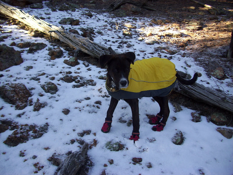 Rufus just can't figure out why I'm laughing at him.... We headed out right at 8:30, and started straight up the hill to the southwest. I had logged some waypoints into the GPS to guide us, and I would HIGHLY recommend anyone trying this route to do the same. With very little time out of the trees along the route, it is easy to lose your bearings. It was hard to locate landmarks to use the compass precisely. The first 1,000' (8600'-9600') went by quickly, and the deadfall through this area was minimal. I aimed just to the south of Pt. 9957 on the ascent. It was steep, but we still made good time. In fact, we were probably headed up a bit faster than we should have because I was starting to sweat, which I obviously try to avoid in the winter. It was warm enough that I was able to wear a light fleece jacket the entire day. 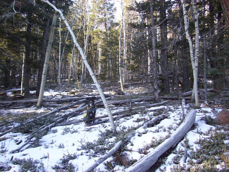 Terrain example for the first 1,000'. Deadfall here wasn't too bad. 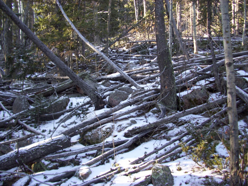 Choose the route wisely. 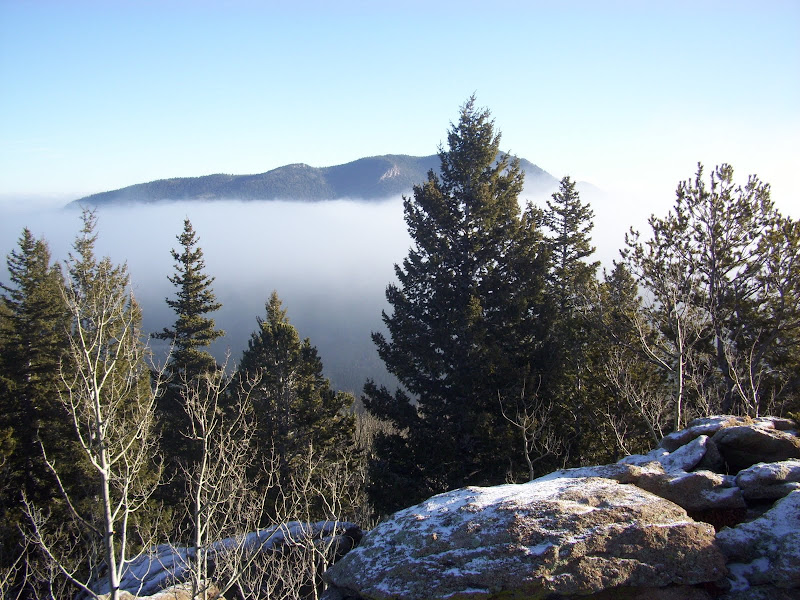 Green Mountain from Pt. 9957 on the way up. 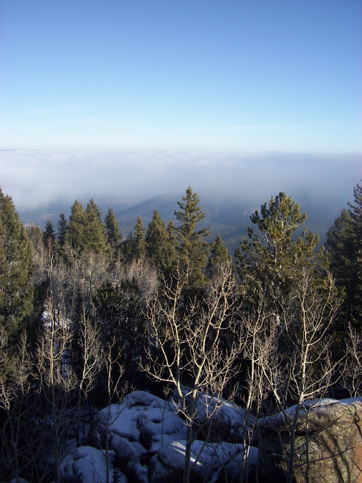 Clouds still lingering around 9,000'. The next 1,000' (9600'-10600) took a bit more effort. Here, the deadfall was starting to get quite a bit worse. Normally in LCW deadfall you can find animal paths to help lead through the tough areas. On Buffalo, I could not find ANY sort of animal trail. To add to the issue, the snow had begun to get a bit deeper. Although the snow level was still only a few inches, it made navigating the steps through the downed trees a bit tougher. A lot of concentration went into each step. 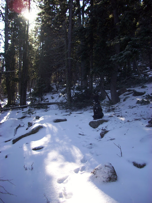 Waiting patiently for the slow poke taking pictures. 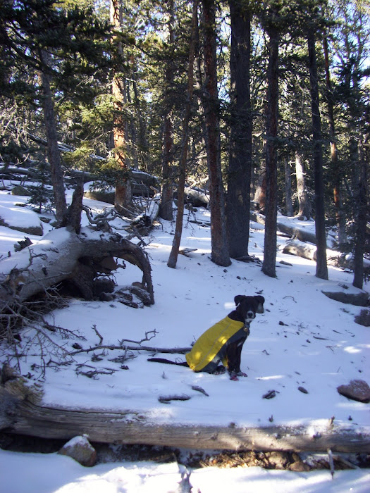 Taking a breather on the slope. Rufus and I took a little breather near Pt. 10778 to rehydrate. From here, there was only one more 1,000 foot section to go until the summit area, and this section was TOUGH. Snow was now up to my knees in spots and the deadfall was just as bad as ever. Rufus was content to follow my path in the snow. Up and up we went, weaving left and right trying to find the most accessible path. Finally, we popped out into the large flat area that Roach describes as the slope relenting. It was nice to finally have flat(ish) ground for the first time all day, although I must say that the non-stop steepness really made the elevation go by quickly. 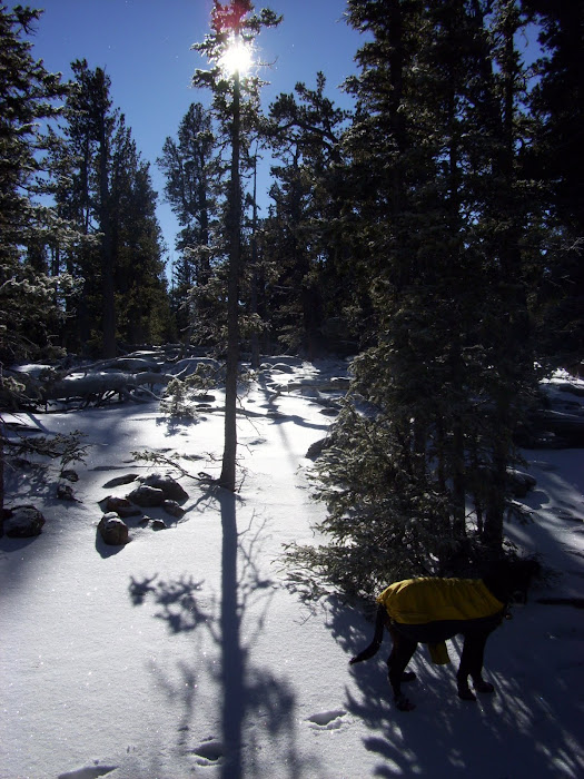 Turning out to be a very nice morning weather-wise.  Snow starting to get a bit deeper. From the flat area, there is only about 100' to gain in a quarter mile. The true summit is blocked by a slightly lower eastern summit. We ended up ascending the eastern summit, however in hindsight we should have kept low and ascended up to the saddle between the two summits. Descending from the eastern summit was difficult in the snow, and Rufus was having a tough time. After finally reaching the saddle, we slowly ascended the true summit. I would say that the final summit area is class 2+, although the snow made it a little slick. Rufus had problems here as well, but I just lifted him up for the short steep sections. He was happy for the ride. To give an indication of how slow the last section went, it took us 2 hours to go from the truck to the eastern summit, and an entire half an hour to go from the eastern summit to the western summit. (Which was a total of only 75 yards horizontal.)  Relaxing terrain on the flat area, about .25 miles shy of the summit.  True summit viewed from the east summit.  Summit. We topped out on the summit right at 11:00, 2.5 hours after leaving the truck. The summit views from Buffalo Peak were definitely top notch. The views of the south Lost Creek Wilderness were fantastic, and it was nice to see some of the places I was earlier in the year. To the south, Pikes Peak loomed large. To the east, Green Mountain and in the far, far distance was Denver.  Sheeprock and Pikes Peak to the south. 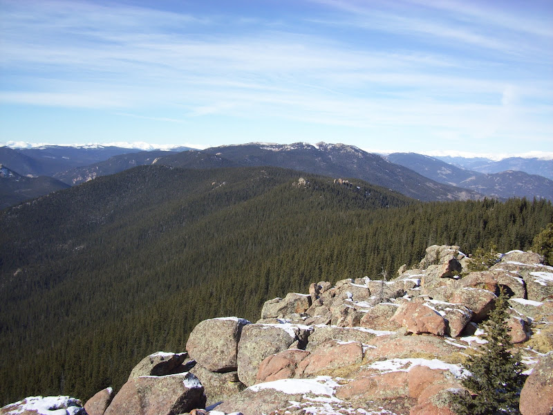 Windy Peak to the Northwest. 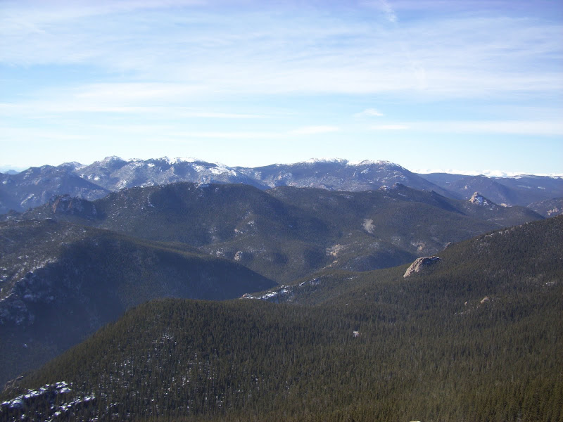 McCurdy (l) and Bison (r) to the west.  Pt. 10654, Pt. 10605 and other peaks towards the Goose Creek area. We hung out for 15 or so minutes and had lunch. Rufus took a quick snooze. We then picked our way down the summit area, and instead of retracing our steps up the eastern summit we circled north below it. This turned out to be a MUCH easier option. Normally, my descents go quickly. I would say on average, my descent time is around half the ascent time. Not Buffalo Peak. I actually felt like going down was worse than the ascent. I remembered thinking "did I really come up through all this crap?!" Slowly, we retraced our path down. We both slipped and fell a few times, but we made it down without incident. It took just under 2 hours to descend, and we arrived back to the truck around 1:00.  "You coming?!"  Navigating the deadfall on our way down. This is normally where I state how great a hike was, and how I'd like to go back someday. But to be honest, although the summit was terrific, and route was quite annoying. If I DID do it again, it was be the long route from the west. Regardless, it was nice to spend Christmas Eve with the pup. Cheers. 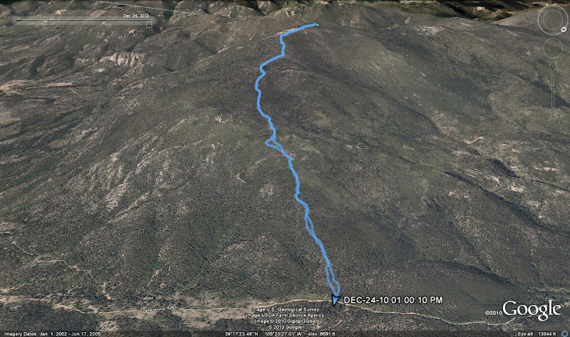 Googleearth Track of our morning.  Quick glimpse of "The Castle" on the way out near Wellington Lake. |
| Comments or Questions | |||||||||
|---|---|---|---|---|---|---|---|---|---|
|
Caution: The information contained in this report may not be accurate and should not be the only resource used in preparation for your climb. Failure to have the necessary experience, physical conditioning, supplies or equipment can result in injury or death. 14ers.com and the author(s) of this report provide no warranties, either express or implied, that the information provided is accurate or reliable. By using the information provided, you agree to indemnify and hold harmless 14ers.com and the report author(s) with respect to any claims and demands against them, including any attorney fees and expenses. Please read the 14ers.com Safety and Disclaimer pages for more information.


