Download Agreement, Release, and Acknowledgement of Risk:
You (the person requesting this file download) fully understand mountain climbing ("Activity") involves risks and dangers of serious bodily injury, including permanent disability, paralysis, and death ("Risks") and you fully accept and assume all such risks and all responsibility for losses, costs, and damages you incur as a result of your participation in this Activity.
You acknowledge that information in the file you have chosen to download may not be accurate and may contain errors. You agree to assume all risks when using this information and agree to release and discharge 14ers.com, 14ers Inc. and the author(s) of such information (collectively, the "Released Parties").
You hereby discharge the Released Parties from all damages, actions, claims and liabilities of any nature, specifically including, but not limited to, damages, actions, claims and liabilities arising from or related to the negligence of the Released Parties. You further agree to indemnify, hold harmless and defend 14ers.com, 14ers Inc. and each of the other Released Parties from and against any loss, damage, liability and expense, including costs and attorney fees, incurred by 14ers.com, 14ers Inc. or any of the other Released Parties as a result of you using information provided on the 14ers.com or 14ers Inc. websites.
You have read this agreement, fully understand its terms and intend it to be a complete and unconditional release of all liability to the greatest extent allowed by law and agree that if any portion of this agreement is held to be invalid the balance, notwithstanding, shall continue in full force and effect.
By clicking "OK" you agree to these terms. If you DO NOT agree, click "Cancel"...
I've been camping in this area a few times and saw Mt. Eva in the distance and always thought it looked like it would be fun to climb. The east ridge looked like the most enjoyable way to the summit except I couldn't find any info on this. Summitpost has a very brief description, but it seemed they didn't gain the ridge until the majority of the way to the top. So I asked on here for any info about it and thanks again to Doug Shaw for posting the pics of the side view of Eva for us. This was all I could find, but it was good enough to get an idea of what it would be like for us to attempt it.
The east ridge of Mt. Eva on the approach
We took off early Saturday morning expecting that we would have to snowshoe all the way up Rainbow Road, but luckily it had been plowed about a mile up, which was a nice surprise.
Rainbow road
We made good time on the road and were soon going across Chinns and Sherwin Lakes. Once we made it to the end of Sherwin we headed North up the slope towards Slater lake right below where we were going to find the best way to make it to the ridge. There is a class 5 headwall at the very beginning of the ridge which we decided to bypass on the left.
Tony with part of the east ridge in the background.
Our route to the ridge took the wind swept rocks on the right of the tree up through the narrow gully. From there we stayed on the left side of the buttress all the way to the ridge top.
Here's a cropped in view of the same pic giving you a better view of the route. This area was definitely the crux of the whole route
Starting up the face
It took over an hour just to get to the top of the ridge and once we did the weather started to turn. The clouds were starting to move in quick towards us and the wind was starting to pick up.
From the picture we got from Doug I thought this area was going to be the crux, but we were able to bypass this section by crossing the snow field in the left side of the pic
We took the rocks up on the right to the upper portion of the snowfield and crossed there. Luckily the snow was stable or this might have been a little interesting.
Once we got past that, the rest of the ridge was pretty straight forward. There was some class 3, but the majority of it was about class 2.
And the clouds continued to roll in
By this point the wind was blowing extremely hard and it would push you to the side if you didn't brace yourself, but we just kept our heads down and kept on moving and soon we made the summit. To bad we didn't have a nice sunny view.
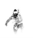
We were a little frosty
We didn't take any pics on the way down cause the whiteout continued, but we had a solid day on this fun ridge,
but here's one more shot of Eva from the morning
Thumbnails for uploaded photos (click to open slideshow):
The road was plowed to that big house on the left just past a mile, by the owner and myself at Christmas. His waterline was froze, and we tried to have it thawed via welder, to no avail. I will be installing a heating cable in it this summer. Usually the road is not passible past the first 2 houses on the right.
At some point there will be folks living back there full time and the road will be plowed ”full time”. Nice report! Great pic's! My boy loves the reservoir, another great sledding area, besides the hiking.
Caution: The information contained in this report may not be accurate and should not be the only resource used in preparation for your climb. Failure to have the necessary experience, physical conditioning, supplies or equipment can result in injury or death. 14ers.com and the author(s) of this report provide no warranties, either express or implied, that the information provided is accurate or reliable. By using the information provided, you agree to indemnify and hold harmless 14ers.com and the report author(s) with respect to any claims and demands against them, including any attorney fees and expenses. Please read the 14ers.com Safety and Disclaimer pages for more information.
Please respect private property: 14ers.com supports the rights of private landowners to determine how and by whom their land will be used. In Colorado, it is your responsibility to determine if land is private and to obtain the appropriate permission before entering the property.


")
")
")
")
")
")
")
")
")
")
")
")
")
")
")
")
")
")
")