Download Agreement, Release, and Acknowledgement of Risk:
You (the person requesting this file download) fully understand mountain climbing ("Activity") involves risks and dangers of serious bodily injury, including permanent disability, paralysis, and death ("Risks") and you fully accept and assume all such risks and all responsibility for losses, costs, and damages you incur as a result of your participation in this Activity.
You acknowledge that information in the file you have chosen to download may not be accurate and may contain errors. You agree to assume all risks when using this information and agree to release and discharge 14ers.com, 14ers Inc. and the author(s) of such information (collectively, the "Released Parties").
You hereby discharge the Released Parties from all damages, actions, claims and liabilities of any nature, specifically including, but not limited to, damages, actions, claims and liabilities arising from or related to the negligence of the Released Parties. You further agree to indemnify, hold harmless and defend 14ers.com, 14ers Inc. and each of the other Released Parties from and against any loss, damage, liability and expense, including costs and attorney fees, incurred by 14ers.com, 14ers Inc. or any of the other Released Parties as a result of you using information provided on the 14ers.com or 14ers Inc. websites.
You have read this agreement, fully understand its terms and intend it to be a complete and unconditional release of all liability to the greatest extent allowed by law and agree that if any portion of this agreement is held to be invalid the balance, notwithstanding, shall continue in full force and effect.
By clicking "OK" you agree to these terms. If you DO NOT agree, click "Cancel"...
Since the time of year really means nothing in terms of "ski season", we thought we should get some winter skiing experience in May. Driving up to the Leadville area it was evident that though summer is swiftly approaching, there is still a bounty of lines to be claimed in the hills.
See the HD video here:
Last year we completed a ski of Belford around mid May and there was significantly more snow on the lower trail this year. Leaving the TH at 7:15, we were able to skin on continuous snow after about 1/3 of a mile, the snow at the near the bottom was mostly frozen solid and softened to allow for better skinning with each switchback. After skinning all winter you forget how much harder simply walking up the trail is and, therefore we made quick time on the skis up to the creek crossing. There were about 3-4 patches of dry ground (which will probably be bigger now) that were about 2-5 feet in length after the switchbacks ended and before the crossing. From the crossing to past the old cabin was unremarkable but provided for good skinning again.
The weather couldn't have been better. Non-existent wind caught us off guard because...well...how can you be in the mountains without wind?? Sunscreen re-applied we continued up the Missouri drainage. Temps were pretty warm but not warm enough for wet slides. Maybe a different story later this week...
Up to the west, a recent (likely within 1 week) large slab avalanche on approx. the same aspect as what we'd be skiing was duly noted and brought a bit of question to our goal of climbing/skiing one of the N couloirs. It apparently had failed on two different layers and the crown look to be 10-15' in height. Only one way to find out - keep going and evaluate when we get there.
Light/fluffy snow on the skin up the drainage seemed to represent something you'd find in winter. Thoughts of deep powder in the north couloirs started circulating as we kept looking at our goal the entire approach.
Instead of wrapping around to the left of the knoll before the couloir entrances, we decided to go straight up the knoll. This proved to take more energy than anticipated with the wind crust that lay 4" down that made getting an edge while skinning a difficult task.
Up at the bottom of the Main Couloir we dug a pit and found a 4" layer, that was consolidated but still slightly soft, which released upon isolation. Initially this wasn't a good sign. Further down there weren't as many distinct layers as anticipated and for the most part everything was bonded pretty well. So that was good. The decision was made to continue on and evaluate the snow with each step of effort on the way up the couloir.
It seemed that the 4" layer we found at the bottom only existed in isolated spots and was more prevalent near the bottom apron. In upper locations near the fork in the couloir I found a 1" wind deposited layer on top of some real nice 6" of fluff. Pushing onward and upward in the upper half, our optimism grew even more as the layers disappeared and were replaced with a little something known as powder. "It'll ski alright"
Apparently my aerobic fitness acquired from lots of backcountry tours this winter had evidently waned during the month of April, so needless to say, being the first 14er of the year, the ascent of the couloir was slow going.
Upon topping out I was surprised to find a relatively interesting summit and surrounding ridges (compared to other Sawatch). And as always the view did not disappoint...especially of the Three Apostles.
The wind was still low and no more than 5-10 mph at times on the summit. Time for the fun........
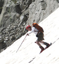
Full summit descent here we come. I went first and found a few turns necessary to figure out what was going on and remember how to ski again.
The GoPro footage was a little overexposed so a little processing was necessary.
And ...yes....it was ...nice. Especially because the layers we found were skiing fairly stable.
A long day but very much worth it. The descent took about a 1/3 of the ascent time. Skiing down always makes for a better day.
9 miles :: 4,500 ft Vert :: Somewhere around 7.5 hrs
Thumbnails for uploaded photos (click to open slideshow):
We followed your ski tracks all the way up into the upper valley below Belford and Missouri today. We went up Belford today with great views and perfect weather. Well done guys
Edit: We saw that exact same slab avalanche today you have pictured in photo 5
just watchin this now because I'm planning to ski it, it's a good write up! nice pics and nice vides!
Caution: The information contained in this report may not be accurate and should not be the only resource used in preparation for your climb. Failure to have the necessary experience, physical conditioning, supplies or equipment can result in injury or death. 14ers.com and the author(s) of this report provide no warranties, either express or implied, that the information provided is accurate or reliable. By using the information provided, you agree to indemnify and hold harmless 14ers.com and the report author(s) with respect to any claims and demands against them, including any attorney fees and expenses. Please read the 14ers.com Safety and Disclaimer pages for more information.
Please respect private property: 14ers.com supports the rights of private landowners to determine how and by whom their land will be used. In Colorado, it is your responsibility to determine if land is private and to obtain the appropriate permission before entering the property.


")
")
")
")
")
")
")
")
")
")
")
")
")
")
")
")
")
")
")
")
")
")
")