Download Agreement, Release, and Acknowledgement of Risk:
You (the person requesting this file download) fully understand mountain climbing ("Activity") involves risks and dangers of serious bodily injury, including permanent disability, paralysis, and death ("Risks") and you fully accept and assume all such risks and all responsibility for losses, costs, and damages you incur as a result of your participation in this Activity.
You acknowledge that information in the file you have chosen to download may not be accurate and may contain errors. You agree to assume all risks when using this information and agree to release and discharge 14ers.com, 14ers Inc. and the author(s) of such information (collectively, the "Released Parties").
You hereby discharge the Released Parties from all damages, actions, claims and liabilities of any nature, specifically including, but not limited to, damages, actions, claims and liabilities arising from or related to the negligence of the Released Parties. You further agree to indemnify, hold harmless and defend 14ers.com, 14ers Inc. and each of the other Released Parties from and against any loss, damage, liability and expense, including costs and attorney fees, incurred by 14ers.com, 14ers Inc. or any of the other Released Parties as a result of you using information provided on the 14ers.com or 14ers Inc. websites.
You have read this agreement, fully understand its terms and intend it to be a complete and unconditional release of all liability to the greatest extent allowed by law and agree that if any portion of this agreement is held to be invalid the balance, notwithstanding, shall continue in full force and effect.
By clicking "OK" you agree to these terms. If you DO NOT agree, click "Cancel"...
Marble Mountain - 13,266 Feet
Sangre de Cristo Range
May 28, 2011
Trailhead: Rainbow Trail junction on South Colony Lakes Road Route: Northeast Ridge Distance: About 6 miles Trailhead Elevation: ~9,850 Who: Bob "BobbyFinn," Kate "KatieFinn," and Valerie "IHikeLikeAGirl" Start: About 5:30 am End: About 1:15 pm
We met at the 2WD parking lot at 5 am. Wow. That's early! We haven't been ready to hike that early in a while and we're out of practice. A few minutes of Valerie's capable driving later and we were at the Rainbow Trail junction on South Colony Lakes Road. We started hiking soon after. There's room for at least 4 cars right at the junction.
There were a couple of rough areas on the road to the junction. I think it would be difficult to get a non-4WD vehicle to the junction, but I'm sure someone will drive a lowered Corvette up there just to say they did it.
We started up the very good Rainbow Trail until the top of the ridge crest. Looking back at the Rainbow Trail
The route description we had said that you'd gone too far if you start going down the other side of the ridge. Well, we went too far, at least initially. I don't know if it was the early morning light or what, but we missed the trail. We spent a few minutes looking for a trail or a cairn or anything that would indicate a right turn, but we came up short. So we just started bushwhacking up near the top of the ridge. Valerie had loaded the route into her GPS, but even with that we didn't see anything that looked like a trail.
There was some pink surveyor's tape on some of the trees that we followed for a while and this worked ok. On the way back down, we built a cairn at the trail junction. The trail junction and the cairn we built.
The Rainbow Trail continues to the left and the "Marble Trail" (or whatever it's called) goes to the right.
Another view of the junction: Trail junction. Photo - IHikeLikeAGirl
The bushwhack wasn't too bad, but it was definitely slow going and we zigzagged a bit to find an easy path through the forest. Finding the trail would have made for an easier and faster ascent... Kate and Valerie in the trees. Valerie's jacket made her easy to find.
We did finally find the trail. Do you see it there under the snow? We had to put snowshoes on at about 10,600 ish. Above about 10,800 it was constant snow until a little above treeline. That's the trail. I think.
A sea of snow. Snow. Photo - IHikeLikeAGirl
On the ascent, we got sucked down to the left (south) near the point marked 10,725 on the Crestone Peak topo map. You really need to try to stay as close to the top of the ridge as you can. From P10,725 to maybe 10,800 or so, we were able to take our snowshoes off, but they went back on soon enough...
Back on track, we were in snowshoes for much of the rest of the hike. Some of the snow supported our weight, but enough didn't that snowshoes were required. On snowshoes. Maybe we're on the trail... Photo - IHikeLikeAGirl
Finding a route. Photo - IHikeLikeAGirl
It was a pretty abrupt treeline. You can see the shadows near Kate from the last trees of the forest. Past here there were some stunted pine trees, but was pretty sparse until even those little guys couldn't grow. Here's Valerie leading the way with Kate watching. Treeline
The snow still required snowshoes - it was soft and melty.
The view up the final push was deceiving. It looked pretty close, but our GPSs said it was still almost 1,000 feet of elevation gain. It didn't matter, the last bit went by pretty fast. Though the wind here was really blowing hard. I thought that the wind would lessen the higher we went - maybe it was just being funneled out of the South Colony Lakes basin. Nope. It was windy all the way to the summit. There isn't much of a wind break on the summit so we didn't stay long. Almost snow-free.
Just to the right of the rock band and out of view of the camera was a flat spot that was an amazing "scenic overlook." Scenic overlook
Photo - I HikeLikeAGirl
We were hiking on grassy terrain just above the scenic overlook... Kate's hiking on grass just above the scenic overlook.
... but it got rockier a couple hundred feet below the summit. Valerie is making her way through high winds and rocks on the way to the summit. Kate standing on the summit.
It was still class 2, but the wind made it a bit challenging.
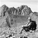
Here's a shot of the view on top. It seems that none of us took many pictures while on the summit. The wind was a bit too strong to make for a leisurely summit break. Summit view. Photo - IHikeLikeAGirl
We reversed our route down the upper part of the mountain and we enjoyed a glissade down the snow slope we snowshoed up. Valerie on the glissade.
Valerie lead us right onto the trail even though it was buried under several feet of snow. The key was to stay as close to the ridge crest as possible. There were some bare spots and after a while we had to snake our way through the forest to piece together continuous snow to avoid unnecessary gear changes. Valerie as Moses.
We had a couple of spots where we took off our snowshoes prematurely. I decided to leave mine off and it was tolerable, while the ladies kept putting them on and taking them off. One time when I was breaking trail a few yards ahead of them they asked me how it looked. I said "It looks like more of the same - a lot of snow." With that they decided to put their snowshoes back on. This was while we were in some thick trees so we couldn't see too far ahead. About 36 steps later, we saw this: No more snowshoes.
The last of the snow. Well, almost, there were a couple of minor drifts after this, but they were easily avoided or just walked-through. I'd bet that most of the snow in the trees will be melted after a couple more weeks.
We were able to follow the trail the rest of the way out. It's definitely not a real distinct trail, but it is there. Parts of the trail are very apparent. Other parts are not. The split off of the Rainbow Trail was visible once we got back to the Rainbow Trail, but going up in the early morning light, I guess it was easy to miss.
Another fun hike with great people.
We hope you liked this report.
Photos were from Bob and Kate except for those IDd as Valerie's.
Thumbnails for uploaded photos (click to open slideshow):
Looks like a great route this time of year. Are you and Kate interested in climbing soon? I have June 10-12 available. I was thinking the Crestones? If not, maybe SW Ridge of LB?
I hiked Marble Mountain early June last year and also overshot the right turn off the Rainbow Trail. I built a nice big cairn at the junction, just like you did, to help others avoid my mistake. Must have gotten knocked down. Great views from up there !
We found a bunch of rocks right near the junction - maybe they were from your cairn. Also, I know there is an ”official” Marble Mountain Trail further down the Rainbow Trail. Maybe someone is trying to keep people on that trail. But the trail we saw looked somewhat used. Who knows. The views were awesome from there. I just wish the wind wasn't so strong.
Thanks for writing this up Bob and thanks to both of you for meeting up with me. Really enjoyed Kate's stories about her mountain mishaps...that have only made her wiser. Made my crawl up to the summit more tolerable.
And 14erkid, good to meet you and your dad. Too bad you were blown off Humboldt.
No kidding. I need to get up there for sunrise. Thanks for the report of a sublime mountain. Well done climb and report.
Caution: The information contained in this report may not be accurate and should not be the only resource used in preparation for your climb. Failure to have the necessary experience, physical conditioning, supplies or equipment can result in injury or death. 14ers.com and the author(s) of this report provide no warranties, either express or implied, that the information provided is accurate or reliable. By using the information provided, you agree to indemnify and hold harmless 14ers.com and the report author(s) with respect to any claims and demands against them, including any attorney fees and expenses. Please read the 14ers.com Safety and Disclaimer pages for more information.
Please respect private property: 14ers.com supports the rights of private landowners to determine how and by whom their land will be used. In Colorado, it is your responsibility to determine if land is private and to obtain the appropriate permission before entering the property.


 Looking back at the Rainbow Trail")
 The trail junction and the cairn we built.")
 Kate and Valerie in the trees. Valerie's jacket made her easy to find.")
 That's the trail. I think.")
 On snowshoes. Maybe we're on the trail... Photo - IHikeLikeAGirl")
 Treeline")
 Almost snow-free.")
 Scenic overlook")
 Kate's hiking on grass just above the scenic overlook.")
 Valerie is making her way through high winds and rocks on the way to the summit.")
 Kate standing on the summit.")
 Valerie on the glissade.")
 Valerie as Moses.")
 No more snowshoes.")
 Snow. Photo - IHikeLikeAGirl")
 Finding a route. Photo - IHikeLikeAGirl")
 Photo - I HikeLikeAGirl")
 Summit view. Photo - IHikeLikeAGirl")
 Trail junction. Photo - IHikeLikeAGirl")