So I'm looking at hiking Grays and Torreys this week and I've been checking out a variety of forecasts (and probably just making myself dizzy without learning anything)
What I've noticed is that on many of the days there's a chance of rain early with a chance of thunderstorms later. Okay, I plan to get going well before dawn so I can be off the summit well before noon. I also plan to be watching the clouds in case thunderstorms develop earlier than forecast.
But if there is rain without thunderstorms in the morning, I don't want to be chased away by the prospect of getting wet if there's no actually dangerous weather. So, is there a way to tell if clouds are just going to bring rain without lightening? Or is that a fool's errand and should I not hiking into any sort of wet weather even if the forecasts say it should only rain and not thunder?
Thanks.
Rain vs Thunderstorms
Forum rules
- This is a mountaineering forum, so please keep your posts on-topic. Posts do not all have to be related to the 14ers but should at least be mountaineering-related.
- Personal attacks and confrontational behavior will result in removal from the forum at the discretion of the administrators.
- Do not use this forum to advertise, sell photos or other products or promote a commercial website.
- Posts will be removed at the discretion of the site administrator or moderator(s), including: Troll posts, posts pushing political views or religious beliefs, and posts with the purpose of instigating conflict within the forum.
For more details, please see the Terms of Use you agreed to when joining the forum.
-
buirechain
- Posts: 10
- Joined: 7/18/2016
- 14ers: 8
- 13ers: 10
- Trip Reports (0)
-
scottaskinger

- Posts: 130
- Joined: 6/28/2011
- 14ers: 39
- 13ers: 7
- Trip Reports (3)
Re: Rain vs Thunderstorms
Interesting. Good question and I don't have an exact answer for you, other than to share my experiences. Anytime, I have been caught in weather (coming down Greys, going up Sunshine, going up Massive) it has been late morning, clouds just seem to "appear" (probably my lack of experience or being behind the mountain and not being able to see approaching weather), thunder/lightning first, hail next and then hail/rain. Before you know it you're soaked. I think it is pretty tough to predict the weather, so I take a preventive maintenance approach.
My strategy now is check the forecast to be aware. Start as early as possible. Be vigilant about watching clouds as I'm hiking up. If I do get caught in weather (which will happen at some point), I'm very quick about getting rain gear on (lightweight OR Helium jacket, rain pants and gloves...about 18 ounces in my pack total). I used to wait thinking "it is just hail, I won't get wet". After being soaked to the bone a few times and being miserably cold descending, I have learned to stop immediately and get the gear on. Also, keep the hands warm. Kind of sucks when you're hands are numb and you can't even zip/unzip your backpack.
My strategy now is check the forecast to be aware. Start as early as possible. Be vigilant about watching clouds as I'm hiking up. If I do get caught in weather (which will happen at some point), I'm very quick about getting rain gear on (lightweight OR Helium jacket, rain pants and gloves...about 18 ounces in my pack total). I used to wait thinking "it is just hail, I won't get wet". After being soaked to the bone a few times and being miserably cold descending, I have learned to stop immediately and get the gear on. Also, keep the hands warm. Kind of sucks when you're hands are numb and you can't even zip/unzip your backpack.
-
XterraRob

- Posts: 1133
- Joined: 7/20/2015
- 14ers: 42 7
- 13ers: 14
- Trip Reports (4)
Re: Rain vs Thunderstorms
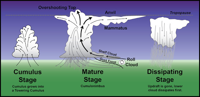
If it's overcast, check the local weather radar for heavy precipitation build up in the area. I run with the MyRadar app to help with this (if you can get service). I'd also be mindful of the heat expected in the area, that's one of the contributing factors to rapid thunderstorm formation in the afternoon.
As for not wanting to get chased away - that's part of the risk you take when you go up there. You can help mitigate it but can't prevent it. Thunderstorms may or may not form while you are up there. A watchful eye/mindfulness of the life cycle of storm cells can help you identify what is going on as you progress through your hike.
As for not wanting to get chased away - that's part of the risk you take when you go up there. You can help mitigate it but can't prevent it. Thunderstorms may or may not form while you are up there. A watchful eye/mindfulness of the life cycle of storm cells can help you identify what is going on as you progress through your hike.
RIP - M56
Re-introduce Grizzly Bears into the Colorado Wilderness™
Re-introduce Grizzly Bears into the Colorado Wilderness™
-
AlexeyD

- Posts: 1286
- Joined: 10/28/2013
- 14ers: 44 4 2
- Trip Reports (3)
Re: Rain vs Thunderstorms
As often is the case with these types of questions...it depends.
The basic ingredients for summer thunderstorms are 1) moisture and 2) lift (a mechanism for moist air to rise, cool, condense, and form convective cells). In the mountains, the mechanism for lift is typically a combination of surface heating (causing the warmed air to rise) and orographic (terrain-driven) forcing. In addition, daytime upslope breezes that meet on a ridge or mountaintop tend to form a convergence zone, providing additional lift (this is why you often see thundercloud build directly over a mountain).
To bring this all back to the question of morning rain: it depends on what kind of rain it is, what is causing this rain, etc. Stratiform (low clouds, usually light) precipitation, for example, is typically associated with a stable atmosphere and a low-level inversion, and will tend to inhibit thunderstorm development. In fact, morning cloud cover, with or without rain, in general will tend to delay surface heating and hence convective activity. On the other hand, if the inversion is shallow and the stratus layer gets "burned off" quickly, then the associated moisture can serve as "fuel" for the storms to later form. Another scenario for morning rain can be associated with the passage of a large-scale weather system such as an upper-level trough or strong front. In this case, both rain and thunderstorms can develop regardless of time of day.
In any case, the graphic that XterraRob provided, and other cloud diagrams, are definitely a good thing to keep in mind. Luckily, building thunderstorms are fairly easy to distinguish from stratus-type clouds. If you want to understand a little more about where the reasoning for a particular forecast is coming from, I highly suggest reading the "scientific discussion" link on the NWS forecast page. Even if you don't understand all of the terminology used there, it should give you a good idea of whether there is something in particular to be concerned about or not.
EDIT: I also wouldn't get too hung up on the specific wording of the NWS point forecasts. Those are generated by an algorithm that has only limited semblance to reality. I would say that in 90% of cases, just assume it means "chance of thunderstorms in late morning/early afternoon". Do pay attention to the % chances, though, as those are indicative of the amount of monsoonal moisture and instability predicted for that day.
-
Sean Nunn
- Posts: 857
- Joined: 7/29/2013
- 14ers: 35
- 13ers: 2
- Trip Reports (0)
Re: Rain vs Thunderstorms
The very short answer, if you are already on the mountain, is that black clouds are very likely to produce thunder, whereas white clouds sometimes produce light rain but rarely thunder. You don't want to count on that simple answer to save your life, but it is a decent rule of thumb that usually works.
"Thy righteousness is like the great mountains."
Psalm 36:6
Psalm 36:6
-
AlexeyD
- Posts: 1286
- Joined: 10/28/2013
- 14ers: 44 4 2
- Trip Reports (3)
Re: Rain vs Thunderstorms
I have to respectfully disagree with this. The color of the cloud depends on how far away from it you are, and what part of the cloud you're looking at. For instance, if you look at a towering cumulus or cumulonimbus cloud from a distance, it will appear white - does this mean it's not a thunderstorm?Sean Nunn wrote:The very short answer, if you are already on the mountain, is that black clouds are very likely to produce thunder, whereas white clouds sometimes produce light rain but rarely thunder. You don't want to count on that simple answer to save your life, but it is a decent rule of thumb that usually works.
I know my answer had a lot (perhaps more than most would want) technical information, but I really don't think that looking at some pictures and learning to recognize the basic shapes, forms, and altitudes associated with different types of clouds is too much to ask for. You don't need to know ALL of them - just being able to recognize those that CAN be associated with thunderstorms should be sufficient.
-
Sean Nunn
- Posts: 857
- Joined: 7/29/2013
- 14ers: 35
- 13ers: 2
- Trip Reports (0)
Re: Rain vs Thunderstorms
Alexey D,
I probably should have kept my mouth shut; I am no expert on weather. Can you please explain this sentence?
"Luckily, building thunderstorms are fairly easy to distinguish from stratus-type clouds."
I think this was the point I was trying to make, but I didn't do a very good job of it.
I probably should have kept my mouth shut; I am no expert on weather. Can you please explain this sentence?
"Luckily, building thunderstorms are fairly easy to distinguish from stratus-type clouds."
I think this was the point I was trying to make, but I didn't do a very good job of it.
"Thy righteousness is like the great mountains."
Psalm 36:6
Psalm 36:6
-
AlexeyD
- Posts: 1286
- Joined: 10/28/2013
- 14ers: 44 4 2
- Trip Reports (3)
Re: Rain vs Thunderstorms
Not at all! Discussion is great, and gives us all an opportunity to learn. For the record, I'm not a meteorologist either, but definitely a "weather nerd" and have taken some courses in the field.
http://www.stormeffects.com/images/8190 ... CbMtn2.jpg
And here is a typical stratus deck (non-convective, widespread clouds associated with steady, light precipitation):
https://encrypted-tbn3.gstatic.com/imag ... _aKLce-lsW
Note that, in this case, the "darker" clouds are actually the less threatening ones. Not trying to bash you for that previous comment, just want to illustrate (with an example) of how you can't always tell by the color alone.
Sure! Here's an example of a "towering cumulus" cloud - an indication of a rapidly developing thunderstorm:Sean Nunn wrote:Can you please explain this sentence?
"Luckily, building thunderstorms are fairly easy to distinguish from stratus-type clouds."
http://www.stormeffects.com/images/8190 ... CbMtn2.jpg
And here is a typical stratus deck (non-convective, widespread clouds associated with steady, light precipitation):
https://encrypted-tbn3.gstatic.com/imag ... _aKLce-lsW
Note that, in this case, the "darker" clouds are actually the less threatening ones. Not trying to bash you for that previous comment, just want to illustrate (with an example) of how you can't always tell by the color alone.
-
Sean Nunn
- Posts: 857
- Joined: 7/29/2013
- 14ers: 35
- 13ers: 2
- Trip Reports (0)
Re: Rain vs Thunderstorms
I understand completely. You are definitely correct. The "towering cumulus" clouds are definitely not always dark. Thank you.AlexeyD wrote:Not at all! Discussion is great, and gives us all an opportunity to learn. For the record, I'm not a meteorologist either, but definitely a "weather nerd" and have taken some courses in the field.
Sure! Here's an example of a "towering cumulus" cloud - an indication of a rapidly developing thunderstorm:Sean Nunn wrote:Can you please explain this sentence?
"Luckily, building thunderstorms are fairly easy to distinguish from stratus-type clouds."
http://www.stormeffects.com/images/8190 ... CbMtn2.jpg
And here is a typical stratus deck (non-convective, widespread clouds associated with steady, light precipitation):
https://encrypted-tbn3.gstatic.com/imag ... _aKLce-lsW
Note that, in this case, the "darker" clouds are actually the less threatening ones. Not trying to bash you for that previous comment, just want to illustrate (with an example) of how you can't always tell by the color alone.
"Thy righteousness is like the great mountains."
Psalm 36:6
Psalm 36:6
-
buirechain
- Posts: 10
- Joined: 7/18/2016
- 14ers: 8
- 13ers: 10
- Trip Reports (0)
Re: Rain vs Thunderstorms
Thank you for the replies and discussion, very enlightening.
(Disclaimer: your aesthetic views may vary)
This is easier said than done. When it comes to phones, I'm a troglodyte. (In other matters not so much--I have a mini tablet for USGS maps). But no smart phone so I'm left with my eyes and the weather report from before I leave.XterraRob wrote:If it's overcast, check the local weather radar for heavy precipitation build up in the area. I run with the MyRadar app to help with this (if you can get service). I'd also be mindful of the heat expected in the area, that's one of the contributing factors to rapid thunderstorm formation in the afternoon.
I think this was exactly what I need. I googled for cloud information/pictures but was overwhelmed with information of the many different types of clouds, most of which don't have much to do with weather. But now I know (more) and can make my own overgeneralization: the better pictures the clouds provide my camera, the more likely the clouds are to kill me (that works for a surprising amount of the natural world).AlexeyD wrote: Sure! Here's an example of a "towering cumulus" cloud - an indication of a rapidly developing thunderstorm:
http://www.stormeffects.com/images/8190 ... CbMtn2.jpg
And here is a typical stratus deck (non-convective, widespread clouds associated with steady, light precipitation):
https://encrypted-tbn3.gstatic.com/imag ... _aKLce-lsW
Note that, in this case, the "darker" clouds are actually the less threatening ones.
(Disclaimer: your aesthetic views may vary)
-
TallGrass

- Posts: 2328
- Joined: 6/29/2012
- 13ers: 26
- Trip Reports (0)
Re: Rain vs Thunderstorms
Sometimes a topo and compass can help predict weather. One reason Death Valley is so dry (it does get rain) is because it's in a "double rain shadow" meaning the air dumps its moisture (rain) on one side so it can get over the range, twice squeegeed in DV's case. A humid day where the wind is coming from an open plain on a hot snow-melting day (think many of the Sangres) isn't going to develop like that which has crossed several high ridges before getting to a remote peak (think San Juans). I could see stuff while at Bears Playground dumping towards Challenger in the distance where I'd been earlier in the day, but was dry all the way out SCL and back to Westcliffe.
+1 to cloud reading. The color can be an indicator, but factor in where you, the cloud(s), and the sun are in relation to each other. Black cloud directly overhead (vertical) isn't like a dark one at eye level (horizontal). Note in the forecast whether there's a Warm or a Cold front coming through. Warm tends to produce lighter, steady, day-long rain from gradual lifting, whereas Cold is heavy and fast from sudden. Pay attention and pactice at home and when driving (you can drive through whole systems crossing the plains), not just when up in the mountains.
+1 to cloud reading. The color can be an indicator, but factor in where you, the cloud(s), and the sun are in relation to each other. Black cloud directly overhead (vertical) isn't like a dark one at eye level (horizontal). Note in the forecast whether there's a Warm or a Cold front coming through. Warm tends to produce lighter, steady, day-long rain from gradual lifting, whereas Cold is heavy and fast from sudden. Pay attention and pactice at home and when driving (you can drive through whole systems crossing the plains), not just when up in the mountains.
"A few hours' mountain climbing make of a rogue and a saint two fairly equal creatures.
Tiredness is the shortest path to equality and fraternity - and sleep finally adds to them liberty."
Tiredness is the shortest path to equality and fraternity - and sleep finally adds to them liberty."
-
scottaskinger
- Posts: 130
- Joined: 6/28/2011
- 14ers: 39
- 13ers: 7
- Trip Reports (3)
Re: Rain vs Thunderstorms
Thanks for the great info in this thread. Anymore cloud pictures?! Those are really helpful to visualize and practice with...like cloud flashcards!

