Colorado peak questions, condition requests and other info.
Forum rules
This is a mountaineering forum, so please keep your posts on-topic. Posts do not all have to be related to the 14ers but should at least be mountaineering-related.
Personal attacks and confrontational behavior will result in removal from the forum at the discretion of the administrators.
Do not use this forum to advertise, sell photos or other products or promote a commercial website.
Posts will be removed at the discretion of the site administrator or moderator(s), including: Troll posts, posts pushing political views or religious beliefs, and posts with the purpose of instigating conflict within the forum.
For more details, please see the Terms of Use you agreed to when joining the forum.
Rainier_Wolfcastle wrote:Its class 2+, but as I've discussed many times with my friends, I would take exposed solid class 3 over exposed class 2+ anytime.
+1
There are even class 4 routes (Sunlight, Lindsey NW ridge) that I would easily repeat before other class 2+ routes (challenger,Lindsay Standard)
I agree with many that loose rocks makes a climb way harder, more dangerous, and for me a lot more scary. The route from the Fuller/Vermilion saddle to the summit of Vermilion I found pretty good. Yes loose, but not like others. 4 climbers came down while I went up the gully, not a rock rolled. Loose on Little Bear is a deadly shooting gallery from above, Vermilion had little potential for harming others as the loose sections were short (assuming you stick nose to but, or wait for each climber to complete before entering fall line). For me it was less scary than the 2+ move on Sneffels standard route because I felt that single move was much more exposed, though very solid. With my girls I am much more worried about my percieved danger than rating. I find that harm and death potential can be much different than a rating. I think Crestone Peak and Needle are safer than Vermilion because they are so solid, but also have a lot more fall potential if you're not concentrating. Loose rock is just scary, especially with younger and/or less experienced climbers. To me 2+ just means very little 3rd class, 2 means route finding ability required, 3 means fun if solid but would bring protection for my young ones. Someone should come up with a rating for loose rock danger.
Better than Vermillion IMO:
Sneffels by SW ridge, harder but solid
Longs peak by loft, harder but solid
wetterhorn, harder but solid
Castle pk, standard summer route, very much like vermilion, but less danger from loose rock
do you see my preference yet?
Lamer/less safe IMO:
Sneffels by standard, more rock fall hazard
Longs by key hole, the trough is loose/scary with so many climbers
Little bear by hourglass, duh
I climbed Vermillion last Saturday (8/2) and agree about the loose rock being the issue. Vermillion is definitely 2+, and the final gully is loose enough that you need to take your time and pick through all the crumbling rock. Staying to the climber's right offered a more stable route up the gully. Other than the gully, the route was very straight forward and actually very fun. The final 30ft ridge to the summit was fairly exposed but was solid enough that it gave little pause. I would say that Castle peak was a pretty comparable hike, although Castle is longer and much more strenuous.
Golden Horn was definitely a step up in difficulty, but the climbing was very enjoyable class 3 near the true summit, and a couple class 4 moves to summit the fantastic false summit.
I know I'm getting old, but I climbed Vermilion on July 6th this year, don't remember touching a foot on a loose gully. But there was still plenty of snow so I suppose that was covering the loose stuff.... Anyway, I agree, class 2+ or easy-3, about the difficulty level of, say, Kit Carson, Lindsey or Sneffels, maybe Crestone Peak-ish. Great snow climb; get there in June/early July and make it even easier.
I just took my boys up Crestone Needle yesterday and we all agreed that Crestone Needle had a much longer technical route, but we felt it was a much safer and more pleasant route than Vermillion.
From what I recall, I agree with everyone who says 2+. Even with snow on the east side, I don't remember it being that horrid, honestly...the west side was mostly fun, with just that one moderately treacherous, loose, steep but short gully below the summit, and some loose rock above. I'd call it more hazardous than difficult, and maybe put it amongst the lowest of the "Difficult" 14ers.
It also has some of the most astonishing scenery in Colorado--the Ice Lakes are incredible!
"If trees could scream, would we be so cavalier about cutting them down? We might, if they screamed all the time, for no good reason."
— Jack Handy
We hiked Vermillion via the standard SE ridge. I remember it as easy class 1/2, with a very short, but not intimidating stretch of class 2+ loos-ish gully near the top. Comparable to the "crux" of Uncompahgre maybe? I contemplated the NE Ridge to connect with Golden Horn, but it looked like a lousy descent and I opted to backtrack our SE Ridge ascent route and go the easier way.
I agree that the standard route is similar to Castle, Ellingwood or Sneffles-sans-summit-step. Not even close to Longs in terms of overall difficulty or no-fall zones. I'd rank it towards the mid-higher range of the "moderate" 14ers. Vermilion has a pretty decent trail on it and sees multiple summits a week during the summer. As in class 1 until the gully and class 2/2+ (kinda funny there's a distinction between 2 and 2+) through and above.
I did not feel the final gully was as hazardous or loose as it this thread suggests. It was all of 40ish ft with the large stuff long cleared out. From a slope stability standpoint, I was considerably less concerned about the gully than I was about knocking stuff down onto a guy and his dogs in the gully from near the summit, so I waited about a minute until they were clear.
Snow would make Vermilion a whole lot nicer.
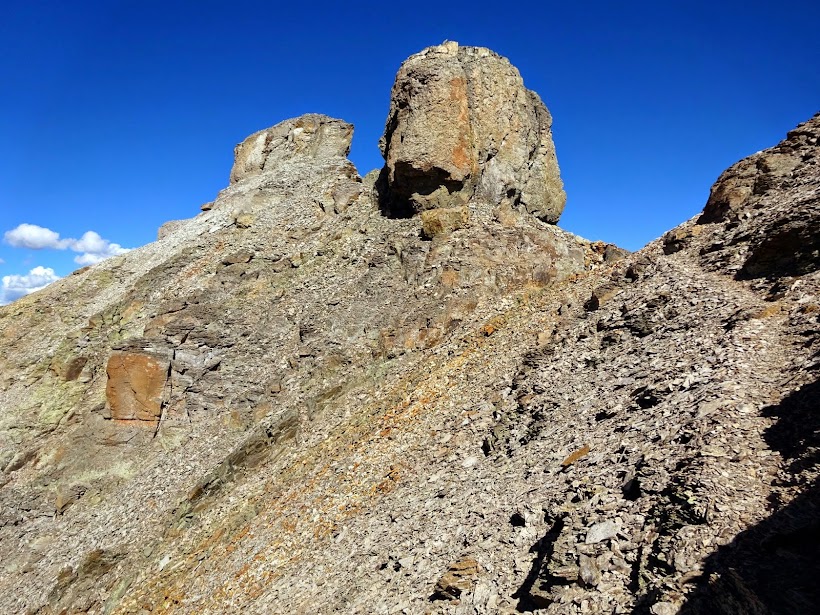
Follow trail around left of tower then right up gully and left/up to summit
"The road to alpine climbing is pocked and poorly marked, ending at an unexpectedly closed gate 5 miles from the trailhead." - MP user Beckerich