Yup that's it. IIRC the distance and gain from purgatory to the same point were almost double but with less gain on the way out.HikerGuy wrote: ↑Tue Sep 20, 2022 8:34 pmThat jives with the track I drew in CalTopo, https://caltopo.com/m/E0M18.
Chi basin from Missionary ridge road
Forum rules
- This is a mountaineering forum, so please keep your posts on-topic. Posts do not all have to be related to the 14ers but should at least be mountaineering-related.
- Personal attacks and confrontational behavior will result in removal from the forum at the discretion of the administrators.
- Do not use this forum to advertise, sell photos or other products or promote a commercial website.
- Posts will be removed at the discretion of the site administrator or moderator(s), including: Troll posts, posts pushing political views or religious beliefs, and posts with the purpose of instigating conflict within the forum.
For more details, please see the Terms of Use you agreed to when joining the forum.
Re: Chi basin from Missionary ridge road

Re: Chi basin from Missionary ridge road
Amazing. Thanks everyone.
Traveling light is the only way to fly.
IG: @colorado_invasive
Strava: Brent Herring
IG: @colorado_invasive
Strava: Brent Herring
-
tortilla
- Posts: 88
- Joined: 9/21/2020
- 14ers: 58
- 13ers: 78
- Trip Reports (0)
Re: Chi basin from Missionary ridge road
Jorts, perhaps try to check fishing sites for beta. Webb, emerald pear and ruby offer good fly fishing.
I recently spoke with a Durango local who’s husband/son were on a fishing trip there. She mentioned that they accessed the “easy way” (from missionary ridge.) This implies that there is another way to access the lakes, presumably from below.
Sat images on Google maps show a trail segment east of emerald but it then enters the trees and is no longer visible on sat.
Please update if you try this, after my conversation with the local I was mulling over this too. Getting back to your car seems to be the issue.
-
tortilla
- Posts: 88
- Joined: 9/21/2020
- 14ers: 58
- 13ers: 78
- Trip Reports (0)
Re: Chi basin from Missionary ridge road
@JortsDaveLanders wrote: ↑Tue Feb 18, 2014 8:03 pm On the descent from Webb Lake back to Needle Creek, I found quite a bit
of an old switchbacked trail, but it wasn't continuous at the bottom. The trail was all on the west side of the outlet creek from Webb Lake,
and came out just across Needle Creek from New York Creek. I've read elsewhere that the trail shown on the topo going to Ruby and Emerald
Lakes from Needle Creek doesn't actually exist.
Re: Chi basin from Missionary ridge road
Thanks. I'll let you know... but I'm leaning towards "Kennedy Pass". It's all above treeline until the base of the gully so it seems it should be easier route finding and others on the forum have had good experience with that route.tortilla wrote: ↑Wed Sep 21, 2022 9:35 am@JortsDaveLanders wrote: ↑Tue Feb 18, 2014 8:03 pm On the descent from Webb Lake back to Needle Creek, I found quite a bit
of an old switchbacked trail, but it wasn't continuous at the bottom. The trail was all on the west side of the outlet creek from Webb Lake,
and came out just across Needle Creek from New York Creek. I've read elsewhere that the trail shown on the topo going to Ruby and Emerald
Lakes from Needle Creek doesn't actually exist.
Traveling light is the only way to fly.
IG: @colorado_invasive
Strava: Brent Herring
IG: @colorado_invasive
Strava: Brent Herring
-
Bigfoot
- Posts: 63
- Joined: 6/25/2008
- 14ers: 58 1
- 13ers: 19
- Trip Reports (0)
- Contact:
Re: Chi basin from Missionary ridge road
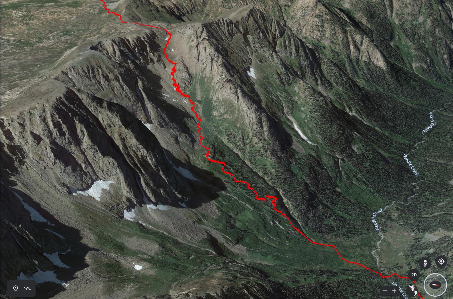
Here is my GPS track zoomed in on the "Kennedy Pass" to Needle Creek section. There is a good goat trail down to treeline. I crossed the first creek and paralleled the second creek down just inside the trees. That worked for a while, but then the deadfall made it tough. Eventually I ended up in the creek bed before making a push through the willows to get back to the meadow. In hindsight I probably should have continued further north under the cliffs (into the shadow) and down somewhere along the 3rd creek or even further north, but it looks like there are some cliffs.
To confirm what was previous posted, there is no longer a trail below Emerald lake:
To confirm what was previous posted, there is no longer a trail below Emerald lake:
You can also avoid the last 2 miles of rough 4WD road to Lime Mesa TH by taking a hunter trail along the side of the mesa.PlayGneiss wrote: ↑Tue Aug 02, 2022 10:46 pm There's a trail down to Ruby, faint to Emerald (private helicopter sign for private inholding there), then to the lake below that before it's lost to nature despite what USATopo says having followed the RubyEmerald drainage all the way and across Needle where trail should have crossed twice. You can also drop from the saddle E of Aztec to the mine, as well as cut up the saddle S of Bullion before Trimble.
PlayGneiss wrote: ↑Tue Aug 02, 2022 10:46 pm No need to go to Lime Mesa TH, rather park on the W side and go up that side of the mesa -- there's a high "trail" shelf and a low one used by hunters, and they'll link up to the Ruby/Overlook trail. This avoids the worst of the 4x4 road and arguably keeps it at 2WD.

Re: Chi basin from Missionary ridge road
Jorts, did you try this?
Conservative (not an actual track) stats from Purg to the same point are 13.6 mi. and +3530' / -1586'.
If running, Purg is probably the better option since the drop into Needle Creek isn't very runnable, the delta in RT gain is barely noticeable over the difference in mileage, and the drive up Lime Mesa takes forever even if you don't go to the upper TH. But for sticking it to The Man I like this way.
We finally checked out this approach Oct. 1. There's basically a trail to the W Kennedy pass, or so we perceived in the snow, and down to treeline as mentioned. From there we hugged the N face of Kennedy with minor talus hopping, which the linked map approximates pretty well. From the upper Lime Mesa TH to the Chi Basin trail at roughly the Kennedy-Aztec drainage intersection with Needle Creek, I get 7.8 mi. and +1640' / -2430'.HikerGuy wrote: ↑Tue Sep 20, 2022 8:34 pmThat jives with the track I drew in CalTopo, https://caltopo.com/m/E0M18.
Conservative (not an actual track) stats from Purg to the same point are 13.6 mi. and +3530' / -1586'.
If running, Purg is probably the better option since the drop into Needle Creek isn't very runnable, the delta in RT gain is barely noticeable over the difference in mileage, and the drive up Lime Mesa takes forever even if you don't go to the upper TH. But for sticking it to The Man I like this way.
Re: Chi basin from Missionary ridge road
Thanks for the info. I haven't given it a try yet. This last weekend was my window and I opted to go up to the Twilights Saturday instead.Boggy B wrote: ↑Mon Oct 24, 2022 11:01 am Jorts, did you try this?
We finally checked out this approach Oct. 1. There's basically a trail to the W Kennedy pass, or so we perceived in the snow, and down to treeline as mentioned. From there we hugged the N face of Kennedy with minor talus hopping, which the linked map approximates pretty well. From the upper Lime Mesa TH to the Chi Basin trail at roughly the Kennedy-Aztec drainage intersection with Needle Creek, I get 7.8 mi. and +1640' / -2430'.HikerGuy wrote: ↑Tue Sep 20, 2022 8:34 pmThat jives with the track I drew in CalTopo, https://caltopo.com/m/E0M18.
Conservative (not an actual track) stats from Purg to the same point are 13.6 mi. and +3530' / -1586'.
If running, Purg is probably the better option since the drop into Needle Creek isn't very runnable, the delta in RT gain is barely noticeable over the difference in mileage, and the drive up Lime Mesa takes forever even if you don't go to the upper TH. But for sticking it to The Man I like this way.
Traveling light is the only way to fly.
IG: @colorado_invasive
Strava: Brent Herring
IG: @colorado_invasive
Strava: Brent Herring
Re: Chi basin from Missionary ridge road
Finally did the Kennedy Pass connector between Chicago Basin and Missionary Ridge. We only relied on it for exiting Chicago Basin. I found it to be a viable, appealing alternative to Purg. Here are a few stats and takeaways:
Total vertical from Chicago Basin to the lower parking at Lime Mesa: 2600ft
From Chi Basin to the top of the pass: 2000ft
Total Mileage (from split with Needle Ck Trail): 6.9mi
The route between Needle Creek and the top of Kennedy Pass can be considered two discrete sections: below treeline and above separated by a flat grassy section.
Below treeline:
There is a side trail that splits from Needle Creek trail and provides an easy creek crossing. From here grass quickly gives way to a tangle of willows. There may be a simpler route through but we bushwhacked the willows. After half a mile in and out of thick willows we happened upon primarily low angle slabs and rubble strewn gullies. This provided a weakness through the foliage to a point 1000ft up (above the willows). Here the terrain flattened and you could see the rest of the route.
Above treeline:
Traverse climbers right on flat grassy slopes to a point where you can see the grassy slopes continuing more steeply above. No reason to talus hop. Follow the grassy slopes through intermittent game trails and scat for some easy and steep climbing. Emerge at the pass 1000 ft overhead.
- IMG_2931.jpeg (212.14 KiB) Viewed 556 times
- IMG_2932.jpeg (211.11 KiB) Viewed 556 times
- IMG_2929.jpeg (268.2 KiB) Viewed 556 times
Traveling light is the only way to fly.
IG: @colorado_invasive
Strava: Brent Herring
IG: @colorado_invasive
Strava: Brent Herring

Re: Chi basin from Missionary ridge road
This is awesome Brent.Jorts wrote: ↑Mon Sep 25, 2023 9:06 am Finally did the Kennedy Pass connector between Chicago Basin and Missionary Ridge. We only relied on it for exiting Chicago Basin. I found it to be a viable, appealing alternative to Purg. Here are a few stats and takeaways:
Total vertical from Chicago Basin to the lower parking at Lime Mesa: 2600ft
From Chi Basin to the top of the pass: 2000ft
Total Mileage (from split with Needle Ck Trail): 6.9mi
The route between Needle Creek and the top of Kennedy Pass can be considered two discrete sections: below treeline and above separated by a flat grassy section.
Below treeline:
There is a side trail that splits from Needle Creek trail and provides an easy creek crossing. From here grass quickly gives way to a tangle of willows. There may be a simpler route through but we bushwhacked the willows. After half a mile in and out of thick willows we happened upon primarily low angle slabs and rubble strewn gullies. This provided a weakness through the foliage to a point 1000ft up (above the willows). Here the terrain flattened and you could see the rest of the route.
Above treeline:
Traverse climbers right on flat grassy slopes to a point where you can see the grassy slopes continuing more steeply above. No reason to talus hop. Follow the grassy slopes through intermittent game trails and scat for some easy and steep climbing. Emerge at the pass 1000 ft overhead.
Thanks not only for some killer shots, but the beta on this pass. We've been wondering about this for next year.

