Page 5 of 7
Re: New 14ers.com ANDROID App!
Posted: Mon May 25, 2020 9:18 pm
by Alpine Guy
I use "Convert to GPX", then Add DEM Elevation Data "Best Available". Then under "Advanced Options" I enter Trackpoint Distance Threshold = 4. It seems to improve the accuracy of my tracks - but there's nothing scientific about the values I use. I then import into Gartrip (old but I'm familiar with it) for things like avg speed, elevation gain, etc.
Re: New 14ers.com ANDROID App!
Posted: Tue May 26, 2020 2:06 pm
by BillMiddlebrook
Darin, thanks a bunch for sending me the test data. It's an excellent example of both
horizontal gps signal ping-ponging and
vertical elevation flubs.
The new 14ers.com Android app that Darin used on this hike does NOT currently perform any data correction for these problems, yet. It will in a week or so.

As I mentioned previously in this thread, I have an algorithm that I'm testing with that will be added to the app tracking feature. And did I mention I'm almost done with a GPX import function? That will take a couple more weeks.
Anyway, I ran Darin's GPS track data through the algorithm and it spit out a more-accurate track by removing the horizontal and vertical bad stuff which slopped outside of some reasonable thresholds. These were my final stats on his hike:
Elevation gain: 2680'
Distance: 9.1 miles
Here are some before and after images of the track and it's profile:
Before (Ugh, Darin's phone jumps around more than a chimp on adderall):

- gpsbefore.jpg (31.18 KiB) Viewed 10088 times
Now, let's look at how those horizontal ping-pongs are removed
AFTER running my Android algorithm:

- gpsafter.jpg (17.88 KiB) Viewed 10088 times
Next up, the vertical problems. Darin's phone occasionally provided the wrong elevation for a string of track points before getting back in line. Sometimes up to 1000' of difference, like Darin was testing his Iron Man suit. So, when the algorithm ran, it also adjusted the obvious elevation bouncing...
Before:

- gpsafter_profile.jpg (42.27 KiB) Viewed 10088 times
After:
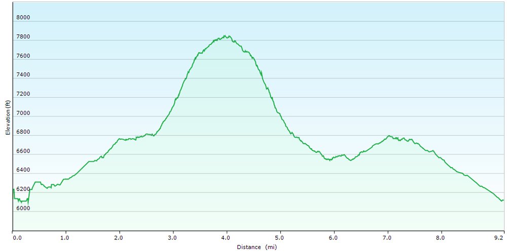
- gpsafter_profile_final.jpg (38.86 KiB) Viewed 10088 times
Re: New 14ers.com ANDROID App!
Posted: Tue May 26, 2020 2:38 pm
by d_baker
So I finally contributed something useful to the site?! It's been a while! Hahaha....
The cleaned up track and stats are very comparable to the mapmyfitness outcome too.
Re: New 14ers.com ANDROID App!
Posted: Tue May 26, 2020 3:40 pm
by rijaca
d_baker wrote: ↑Tue May 26, 2020 2:38 pm
The cleaned up track and stats are very comparable to the mapmyfitness outcome too.
Mapwhatfitness?
Re: New 14ers.com ANDROID App!
Posted: Wed May 27, 2020 8:41 am
by glenmiz
I finally got around to downloading the new app. Thanks, Bill, for everything you do. After reading the discussion about Darin's problems, I'm going to compare the new 14ers.com app to my "old faithful" Backcountry Navigator. I've been using that since 2014 and, aside from occasional problems similar to Darin's, it's been great. I've been reluctant to change but this may just be the KT boundary.
Bill, one question: I don't see a way to designate storage to the phone or SD card. Is there an option to save data on the SD card?
Thanks again!
Re: New 14ers.com ANDROID App!
Posted: Thu May 28, 2020 8:00 am
by BillMiddlebrook
glenmiz wrote: ↑Wed May 27, 2020 8:41 am
I finally got around to downloading the new app. Thanks, Bill, for everything you do. After reading the discussion about Darin's problems, I'm going to compare the new 14ers.com app to my "old faithful" Backcountry Navigator. I've been using that since 2014 and, aside from occasional problems similar to Darin's, it's been great. I've been reluctant to change but this may just be the KT boundary.
Bill, one question: I don't see a way to designate storage to the phone or SD card. Is there an option to save data on the SD card?
Thanks again!
Glen, the app currently uses internal storage only but I hope to add an external use option down the line.
When installed, the app is about 55mb but the real storage consumption comes from downloading route images, for offline use. So, if you feel it's using too much internal storage, the amount of space used can be seen in Storage->Settings (in the app) and images can be removed there. I hope this helps.
Re: New 14ers.com ANDROID App!
Posted: Thu May 28, 2020 8:12 am
by BillMiddlebrook
Alpine Guy wrote: ↑Mon May 25, 2020 9:18 pm
I use "Convert to GPX", then Add DEM Elevation Data "Best Available". Then under "Advanced Options" I enter Trackpoint Distance Threshold = 4. It seems to improve the accuracy of my tracks - but there's nothing scientific about the values I use. I then import into Gartrip (old but I'm familiar with it) for things like avg speed, elevation gain, etc.
This is pretty much what I would do with my personal tracks as well, or I would manipulate them in Garmin BaseCamp.
For the "smoothing" algorithm that will be added to the next version of the Android app, it will adjust the thresholds on-the-fly based on current speed since the user could be hiking, biking or driving.
For example, In Darin's track the average speed was used to set a horizontal threshold of 150' and a vertical of 250'. So track points that exceeded the horizontal threshold were removed and where the vertical was exceeded, we grab a new elevation from an alternate DEM resource. Still more testing to do on it so I can dial in the speed/threshold matrix.
Re: New 14ers.com ANDROID App!
Posted: Thu May 28, 2020 8:16 am
by Jim Davies
When I was messing with GPS tracking, I noticed that the API supplies an "accuracy" number. I tried just ignoring points where the accuracy wasn't low enough, but that sometimes left me with no points at all. Your approach is probably better; my phone's GPS also sometimes jumps around weirdly, or reports a zero elevation (probably cheap hardware issues). On a recent walk, I discovered later that I'd apparently gone swimming a few times...

- swim.JPG (50.08 KiB) Viewed 9940 times
Re: New 14ers.com ANDROID App!
Posted: Thu May 28, 2020 8:47 am
by supranihilest
This raises a couple if interesting questions: what happens with the activity/GPX data tracked with the app? (I'm not talking on a privacy level, but more of a user community level, i.e. is the data available to only the user who tracked it or does it get sent up to a 14ers.com repository somewhere, which leads to my next question.) Is there any desire for a GPX depot of sorts for the site? I religiously track my activities (with a Garmin Fenix 5 watch, mind you) and upload the GPX files to my trip reports, but have often thought that it would be useful to have a place to upload just the GPX, since writing a full fledged trip report is a lot of overhead for sharing data passively gained on a hike/climb. Definitely getting off topic here but something that's been on my mind as a research tool for quite a while.
Re: New 14ers.com ANDROID App!
Posted: Thu May 28, 2020 9:00 am
by HikerGuy
supranihilest wrote: ↑Thu May 28, 2020 8:47 am
have often thought that it would be useful to have a place to upload
just the GPX, since writing a full fledged trip report is a lot of overhead for sharing data passively gained on a hike/climb.
Piggybacking on this, I've always wanted the ability to add a GPX to a conditions report. Same reason, full report not needed, but a GPX does provide valuable beta.
Re: New 14ers.com ANDROID App!
Posted: Thu May 28, 2020 9:12 am
by BillMiddlebrook
supranihilest wrote: ↑Thu May 28, 2020 8:47 am
This raises a couple if interesting questions: what happens with the activity/GPX data tracked with the app? (I'm not talking on a privacy level, but more of a user community level, i.e. is the data available to only the user who tracked it or does it get sent up to a 14ers.com repository somewhere, which leads to my next question.) Is there any desire for a GPX depot of sorts for the site? I religiously track my activities (with a Garmin Fenix 5 watch, mind you) and upload the GPX files to my trip reports, but have often thought that it would be useful to have a place to upload
just the GPX, since writing a full fledged trip report is a lot of overhead for sharing data passively gained on a hike/climb. Definitely getting off topic here but something that's been on my mind as a research tool for quite a while.
The app tracks are stored only on the app. Using the GPX Export function, under My Recordings, you could create a GPX file for use on a trip report.
At this time, there's no single GPX repository on 14ers.com. The closest you can get is to specify "Only with GPX Files" in the search criteria when sub-setting reports on the main
Trip Report page.
Should I provide a GPX Repository? Probably.
If I did that, I would probably add a "Share to Public GPX Repository" flag wherever GPX files are added to the site (Trip Reports and My Map Projects currently). And, of course, just add a direct "GPX Upload" option in the GPX Repository.
Re: New 14ers.com ANDROID App!
Posted: Thu May 28, 2020 1:42 pm
by Jim Davies
It might be convenient to be able to save the GPX track directly to the device's storage, but I can live with Google Drive.