New Fire in the Poudre Canyon
Forum rules
- This is a mountaineering forum, so please keep your posts on-topic. Posts do not all have to be related to the 14ers but should at least be mountaineering-related.
- Personal attacks and confrontational behavior will result in removal from the forum at the discretion of the administrators.
- Do not use this forum to advertise, sell photos or other products or promote a commercial website.
- Posts will be removed at the discretion of the site administrator or moderator(s), including: Troll posts, posts pushing political views or religious beliefs, and posts with the purpose of instigating conflict within the forum.
-
RyanSchilling

- Posts: 171
- Joined: 1/18/2005
- 14ers: 58
- 13ers: 249
- Trip Reports (1)
-
bdloftin77

- Posts: 1090
- Joined: 9/23/2013
- 14ers: 58 1
- 13ers: 58
- Trip Reports (2)
Re: New Fire in the Poudre Canyon
https://airquality.weather.gov/sectors/ ... o.php#tabs
^ Hover over the 1 Hr Average Surface Smoke Squares, or the 1 Hr Average Vertical Smoke Integration Squares. Alternatively, click on the Loops tab to see a live loop of forecasted smoke.
https://hwp-viz.gsd.esrl.noaa.gov/smoke/
^Vertically Integrated Smoke or Surface Smoke. For the Forecast slot time, it tends to show the furthest in the future if you click on a :00, :06, or :12 time. Use the slider at the bottom to view specific times, or to see an animation.
https://www.star.nesdis.noaa.gov/GOES/
^Play with the above website. I use it for imagery and large visible smoke plumes.
Or fire.airnow.gov as mtn_nut mentioned. That's useful for large smoke plumes, as well as satellite fire hotspot readings.
-
ker0uac
- Posts: 547
- Joined: 8/30/2016
- Trip Reports (0)
Re: New Fire in the Poudre Canyon
thank you all, saved me a lot of googling 
Why do places along the I-25 south corridor like Springs get more smoke than places like Leadville? I saw this often last month when Springs would smell like the inside of a wood stove while Leadville's air would be pristine.
Why do places along the I-25 south corridor like Springs get more smoke than places like Leadville? I saw this often last month when Springs would smell like the inside of a wood stove while Leadville's air would be pristine.
Those who travel to mountain-tops are half in love with themselves and half in love with oblivion
-
Vincopotamus

- Posts: 350
- Joined: 12/4/2008
- 14ers: 36 3 3
- 13ers: 10 1
- Trip Reports (0)
Re: New Fire in the Poudre Canyon
Could be a variety of factors, but I'd suspect that a lot of it has to do with smoke settling into lower elevations in the evenings. Without strong winds, it may get trapped in those lower elevations for several days. Leadville sits nearly 4k feet higher so their smoke likely drops and flows down the Arkansas valley.ker0uac wrote: ↑Thu Oct 22, 2020 4:30 pm thank you all, saved me a lot of googling
Why do places along the I-25 south corridor like Springs get more smoke than places like Leadville? I saw this often last month when Springs would smell like the inside of a wood stove while Leadville's air would be pristine.
The only time I lower the bar is après
Re: New Fire in the Poudre Canyon
I agree. Its largely a factor of wind and topography. Smoke is a fluid, so its going to settle down into lower valleys assuming its not completely dissipated by wind. The front range acts as a wind block, so it collects in Denver/Springs real bad. There's not anywhere for it to 'drain' out as fast as it can from LeadvilleVincopotamus wrote: ↑Fri Oct 23, 2020 12:08 pmCould be a variety of factors, but I'd suspect that a lot of it has to do with smoke settling into lower elevations in the evenings. Without strong winds, it may get trapped in those lower elevations for several days. Leadville sits nearly 4k feet higher so their smoke likely drops and flows down the Arkansas valley.ker0uac wrote: ↑Thu Oct 22, 2020 4:30 pm thank you all, saved me a lot of googling
Why do places along the I-25 south corridor like Springs get more smoke than places like Leadville? I saw this often last month when Springs would smell like the inside of a wood stove while Leadville's air would be pristine.
I thought, I taught, I wrought
-
herdbull

- Posts: 442
- Joined: 6/6/2011
- 14ers: 58
- 13ers: 14
- Trip Reports (1)
Re: New Fire in the Poudre Canyon
Has anyone been up hwy 14 towards Cameron Pass since they opened it back up? Cant find any pics of what the area looks like now that the fire is out.

Re: New Fire in the Poudre Canyon
The Larimer sheriff and some other organizations posted video and pics on Facebook, one was a video of the drive and roadside views.
http://www.listsofjohn.com/m/cougar
"If we don't change direction, we'll end up where we're going."
"Bushwhacking is like a box of chocolates - you never know what you're gonna get."
"Don't give up on your dreams, stay asleep"
"If we don't change direction, we'll end up where we're going."
"Bushwhacking is like a box of chocolates - you never know what you're gonna get."
"Don't give up on your dreams, stay asleep"

Re: New Fire in the Poudre Canyon
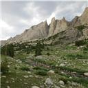
I drive up to Cameron pass and north along Laramie River road monthly.
The burn is mostly obvious west of Rustic on both sides. The lower valleys and near the roadway have been somewhat protected.
Forest service and the County have been clearing out burned trees near the highway and adding tackifier/mulch on many of the slopes for the past few months.
Some pics:


The burn is mostly obvious west of Rustic on both sides. The lower valleys and near the roadway have been somewhat protected.
Forest service and the County have been clearing out burned trees near the highway and adding tackifier/mulch on many of the slopes for the past few months.
Some pics:
"The road to alpine climbing is pocked and poorly marked, ending at an unexpectedly closed gate 5 miles from the trailhead." - MP user Beckerich

