Download Agreement, Release, and Acknowledgement of Risk:
You (the person requesting this file download) fully understand mountain climbing ("Activity") involves risks and dangers of serious bodily injury, including permanent disability, paralysis, and death ("Risks") and you fully accept and assume all such risks and all responsibility for losses, costs, and damages you incur as a result of your participation in this Activity.
You acknowledge that information in the file you have chosen to download may not be accurate and may contain errors. You agree to assume all risks when using this information and agree to release and discharge 14ers.com, 14ers Inc. and the author(s) of such information (collectively, the "Released Parties").
You hereby discharge the Released Parties from all damages, actions, claims and liabilities of any nature, specifically including, but not limited to, damages, actions, claims and liabilities arising from or related to the negligence of the Released Parties. You further agree to indemnify, hold harmless and defend 14ers.com, 14ers Inc. and each of the other Released Parties from and against any loss, damage, liability and expense, including costs and attorney fees, incurred by 14ers.com, 14ers Inc. or any of the other Released Parties as a result of you using information provided on the 14ers.com or 14ers Inc. websites.
You have read this agreement, fully understand its terms and intend it to be a complete and unconditional release of all liability to the greatest extent allowed by law and agree that if any portion of this agreement is held to be invalid the balance, notwithstanding, shall continue in full force and effect.
By clicking "OK" you agree to these terms. If you DO NOT agree, click "Cancel"...
Trailhead: Mahogany Flat Campground parking area, 8,133'
Total Distance Estimate: 13-14 miles
Total Elevation Gain Estimate (out and back, hitting all three peaks): 3,800 feet
Hiking Times for Reference: 3 hours up to Telescope Peak; 2 hours from Telescope to Bennett and then to Rogers; less than an hour from Rogers back to the trailhead (short bushwhack backtrack from Rogers back down to the trail; we did not take the road)
Telescope Peak, the highpoint of Death Valley National Park, has been on our long list for a long time. Jen and I finally checked it off last week with our friend Craig from California, and it was actually much better than I expected. Sure, it was a long slog. But where else can you glance one way and see Mount Whitney, the highest mountain in the United States outside of Alaska, and then look the other way and see Badwater Basin, the lowest point in North America? It was pretty cool.
As a side note, here are three great things about hiking in Death Valley: (1.) When many mountain ranges are getting pummeled with snowstorms this time of year, Death Valley peaks tend to be dry, and they typically only have snow from the late fall through the spring - i.e., it's a good place to get in some high peaks late season or early season. (2.) There are many inexpensive and direct flights to Las Vegas, and Death Valley is only two or three hours away; plus Vegas is a good jumping-off point to access Red Rocks, the Valley of Fire, Great Basin N.P., southeast Utah, the San Francisco Peaks in Arizona, and much more. (3.) After hiking, there are many other things to see and do in Death Valley and/or the Las Vegas area.
Coming from sea level, we made a weak attempt at acclimating by driving up to Aguereberry Point (6,433') the day before our climb. It was a fun drive and the views were spectacular, plus we had the road and viewpoint all to ourselves:
That evening we stayed in a "room" at the Panamint Springs Resort, which was more or less a wooden tent with indoor plumbing. But options are limited in the desert, and this is one of the closer places to stay (Stovepipe Wells is the other, but it's pricey) with good access to the trailhead (it's about an hour from Panamint Springs to Mahogany Flat). I had also read about this place's good beer selection, and it delivered in that respect.
I took the following 5-photo pan near Panamint Springs. Telescope Peak is upper-left. It may not look very mighty in this photo, but in reality, the summit was 9,000 feet higher than where I was standing:
And here's another shot from Panamint Springs taken that evening:
As mentioned, the beer selection did not disappoint, especially for a place that's marooned in the desert and 50 or 60 miles away from the nearest small town. The restaurant had 8 or 10 taps and more than 150 bottled beers, including Belgians, barleywines, imperial IPAs, etc. Needless to say, Jen and I enjoyed quite a few with Craig that evening.
The following morning, Craig played Good Samaritan and gave some guy a ride to find his car. Apparently, on the previous afternoon, this guy went for a short hike on the Panamint Dunes and lost his car. Once it got dark, all he could see were a few lights at the Panamint Springs Resort, so he hiked 7+ miles in the dark toward them. Luckily, some people were still awake at the time and gave him some blankets, and then he spent the night on the restaurant's porch. In the morning, he asked Craig to drive him back to find his car, which Craig did because he's a cool guy.
After a tasty breakfast (aside from the buckwheat pancakes which resurfaced later), we enjoyed the beautiful morning as we drove to the trailhead.
On the drive up, you pass right by some old charcoal kilns at the Wildrose Peak trailhead. You often find kilns like these strategically built in high elevation places (i.e., lower oxygen levels) and near sources of hardwood. They're neat relics of the past. I remember seeing some in Colorado, as well.
Notes on the Road to Mahogany Flat, for those interested: Most 2WD cars can make it to Wildrose, either from the north or west roads. A mile or two beyond Wildrose, the road becomes gravel and gets a little rougher, with some small ruts here and there. With care, many vehicles could make it to the kilns. The last mile or two beyond the kilns is steeper, rockier and more rutted. I made it up in a rental Jeep Liberty 4x4 without too much trouble, but if it were any rougher I probably wouldn't have risked it (I heard that tow trucks charge $1,200 on 4WD roads in the Park). Regardless, ground clearance is a must and some off-road experience is helpful for this road. Also keep in mind, as with many roads in Death Valley, conditions can change drastically from one year to another, and definitely after flash floods.
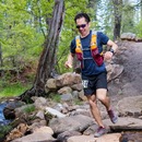
By 9 a.m. we were on the trail, and less than an hour later we got our first glimpse of Telescope Peak. It looked really close, but it was deceiving, as most things are in the desert. Of course, it wasn't a direct route, either. The trail took forever to get around Rogers, then it casually meandered around Bennett, and then it just went on and on along a never-ending ridge.
"I see the summit! We just have 63 miles to go!":
Even though Craig and I were both recovering from colds and Jen wasn't feeling too well, the three of us hiked at a pretty good clip. But just as we reached the steep and final slog to the top, Jen had to stop to make a few deposits. At first, I thought the altitude might be making her sick, but it was actually the buckwheat pancakes she ate for breakfast. She's one tough cookie, though, and she said she felt much better after the fourth puke, so we pushed on. Knowing that dehydration could become a real concern, I kept hounding her to drink water and Gatorade, and she did fine the rest of the day.
Jen on the ridge near the summit:
At about noon we gained the summit and enjoyed it with four other people.
Jen and I may appear to be short in the following photo, but it's only because Craig is actually 8'9" tall:
The 360-degree views were rich and expansive.
Directly below and to our east, we could see Badwater Basin (-282 feet), the lowest point in North America:
To the west, we could see the high Sierras, including Langley, Whitney and Russell:
To the south, more Panamint Mountains:
To the southeast, the southern end of Death Valley:
After spending a half hour or so on top, we pushed on to our next objectives: Bennett Peak and Rogers Peak (shown in the following photo).
Here's a close-up of Rogers Peak; you can see the trail cutting across its southeast side:
The 500-foot bushwhack up Bennett's south side was a slog through scrubby willows and cacti. The thin air had finally caught up to me by this point, and it slowed my pace.
On the summit of Bennett Peak:
Telescope from Bennett:
Mummy Mountain and Charleston Peak, way off to our east:
Rogers Peak also required some bushwhacking, though we took the road for the last stretch to the military-equipment-covered summit:
Telescope and Bennett from Rogers:
We backtracked back down to the trail, rather than taking the long and winding road down Rogers' north side.
Of note: The entire trail up and down Telescope Peak is pleasant class 1, but it does traverse many steep slopes, so I can see how some technical gear might be needed when it's snow covered.
It took us less than an hour to get back to the trailhead from Rogers Peak.
Telescope was a worthy objective on its own, but having attained all three peaks, the accomplishment felt even richer.
Here's a pan I took on the drive out; the view is to the south; lower-left is Badwater Basin and upper-right is Telescope Peak:
Here's a topo of our route; the orange line is our route up; the red lines are our detours up Bennett and Rogers:
After parting ways with Craig, Jen and I had our own Good Samaritan experience. While blasting through the barren desert, we saw some guy waving at us from the side of the road. He had a flat tire and his rental car was missing a tire iron. Luckily, he had a Dodge and we had a Jeep, so the lug nuts were the same size. I could tell he didn't know what he was doing, so I took over and changed the tire for him. He was a German on a month-long vacation, and he was so thankful for our help that he bought us some beers in Stovepipe Wells.
The following morning, Jen and I planned to climb Thimble Peak from Red Pass, but the desert and Telescope had drained the life out of us. That, and by 9 a.m. it was already 80 degrees, so I wasn't really into that plan. So we decided to just drive the Titus Canyon road and do some short explorations along the way.
I was just in Las Vegas last week and considered driving out to Death Valley, now I wish I had. Instead I ended up hiking around Red Rock Canyon, which actually had some good trails and peaks to hit up. Thanks for the report and the reminder of how much there is to do outside of CO.
I did telescope last fall - couldn't believe how hard it was to get an accurate sense of scale there. With so few things for reference, Telescope Peak and Badwater looked so closer than they actually are.
Also, wish I'd know about that beer selection. Thanks for the report.
Great TR! I used to fly low levels out of China Lake in the Panamint Valley just to the west of that ridgeline. Really cool to see all those landmarks from a different perspective. Thanks for another great report.
Nice report. Brings back some good memories of the area.
Caution: The information contained in this report may not be accurate and should not be the only resource used in preparation for your climb. Failure to have the necessary experience, physical conditioning, supplies or equipment can result in injury or death. 14ers.com and the author(s) of this report provide no warranties, either express or implied, that the information provided is accurate or reliable. By using the information provided, you agree to indemnify and hold harmless 14ers.com and the report author(s) with respect to any claims and demands against them, including any attorney fees and expenses. Please read the 14ers.com Safety and Disclaimer pages for more information.
Please respect private property: 14ers.com supports the rights of private landowners to determine how and by whom their land will be used. In Colorado, it is your responsibility to determine if land is private and to obtain the appropriate permission before entering the property.


")
")
")
")
")
")
")
")
")
")
")
")
")
")
")
")
")
")
")
")
")
")
")
")
")
")
")
")
")
")