| Peak(s): |
Mt. Hood - 11249 Half Dome - 8839 |
| Date Posted: | 06/13/2014 |
| Modified: | 06/14/2014 |
| Date Climbed: | 05/11/2014 |
| Author: | jchapell |
| Peak(s): |
Mt. Hood - 11249 Half Dome - 8839 |
| Date Posted: | 06/13/2014 |
| Modified: | 06/14/2014 |
| Date Climbed: | 05/11/2014 |
| Author: | jchapell |
| Mt. Hood, Half Dome, Yosemite - A Perfect Babymoon |
|---|
|
Creeeaaaak! The condition of the cables, poles, and old wood slabs didn't give a ton of confidence as we made our way up the smooth 45+ degree slope of Half Dome's NE slope. We were beginning our third day in the backcountry of Yosemite, the last full day of our trip that began with an attempt on Oregon's Mt. Hood. Finishing the trip with a summit of Half Dome - celebrating our anniversary, one of us pregnant, with the sun rising on us with no one else in sight - was an incredible highlight of the trip. I realize this is far from CO 14er's report, but hopefully it includes some entertaining or useful info for future OR and CA trips. We originally planned to do several climbs in the Cascades in May/June for our anniversary, but then amazingly found out that my wife was pregnant! After some council from a variety of sources (including the doctor!), we decided to stick with Mt. Hood with Timberline Mountain Guides, then head directly to Yosemite for the rest of the trip - now retitled our "Babymoon". Mt Hood, Southside Route, May 10 After arriving with duffels filled with snow gear for Hood and backpacking gear for Yosemite, we spent a short night in Portland and drove to Timberline Lodge for snow school.The days prior to our arrival had absolutely dumped snow on the mountain. Driving up to Timberline (~6000 feet), the historic lodge and ski resort where the TMG office is located, it was an incredible scene of huge evergreens totally covered in white (different from St. Louis's 80+ degree heat). We arrived for our gear check, and our guides told us right off that bat that the large amount of snow and expected warmer temperatures could lead to a high avalanche threat and may keep us from summiting. Despite this knowledge, the 6 of us (plus 2 guides) voted to continue and see what happened. After a quick gear check, we headed out onto the lower slopes for snow school. Our guides, Max and Bryan, were excellent, and gave us great instruction throughout the day in some crappy weather and deep snow.  We met up at the lodge around 2am and took a short snowcat ride partway up the hill. The silhouette of the mountain looked super impressive in the full moon! The driver was only able to make it part way of his normal route because of the deep snow, so we hopped out, geared up (it was around 20F at that point), and started heading up. The snow was deep and soft, but there were plenty of boot tracks to step in. After about 45 minutes we took a break to put on crampons for harder snow. With the sun beginning to brighten the horizon, the views got better and better as we went along. We passed the Silcox Hut, and slowly the slope steepened a bit as we moved towards the Devil's Kitchen and its sulfur stank. The sight of the at the snow encrusted Pearly Gates was gorgeous as the sun continued to rise.   Once we reached the Devil's Kitchen ~10,000ft, the guides cut snow pits, and determined that there was, in fact, a rotten layer of snow under the recent heavy snowfall - not good for our chances to summit. We appreciated that they had another column cut to show us all that even nudging it caused the top layer to collapse, and it seemed like the right decision to turn back.  ")     We hung around and took pictures for a bit, and around 6am headed back down. The descent was uneventful, enjoying the company, talking to our guides and other group members, and drinking in the view. After returning we packed up, drove back to Portland, and napped HARD for a couple hours. We decided to drive to the Columbia River Gorge to see Multnomah Falls, which was crowded, but beautiful. Then we returned to the hotel, went to bed, and got ready for the trip to Yosemite...   We flew to Sacramento and drove the winding 4 hr road to Yosemite, arriving late in the evening. Despite being pretty exhausted and hungry, the first view of the valley was indescribable. We have seen a lot of mountains and landscapes, but Yosemite Valley has to be one of the crowning features of creation. We took it easy on our first day - we woke up early to get sunrise photos from a few places in the Valley (I highly recommend the book "Photographing Yosemite") and then took a tour around the Valley's waterfalls and Granite cliffs and went to Mariposa Grove to see the giant redwoods. Given that this is a hiking trip report, I won't spend more time on here, but these pieces of nature are truly beyond words - I'll put some photos at the bottom of the report.  Glacier Point to Little Yosemite Valley: 6.4 miles The first day in the backcountry began with a bus ride to the Glacier Point trailhead. The weather was hot for May (~80F), and given the late bus ride ( arriving at 10am) we were feeling the heat as the trail is unsheltered for at least half the route. The first quarter mile descending from Glacier Point included incredible views of Half Dome, Liberty Cap, and Vernal and Nevada Falls.  The trail continued to descend through intermittent woods to a stunning viewpoint for 370 ft Illilouette Falls, and further to Illilouette Creek. It then began the climb that would eventually take us to Nevada Falls. Along the way, we had read there was an un-marked turn off for Panorama Point, which we spent WAY too long looking for (though did find it, around .6 miles after Illilouette Creek), and found a small group of people hanging out there who had also found it! We reached the powerful Nevada Falls and enjoyed the mist and the view, but after a few minutes decided to power on towards our destination, Little Yosemite Valley Campground. After ascending a few hundred feet from Nevada Falls, the last mile to LYV follows the Merced River and is mostly peaceful and flat. Given that it was now mid afternoon, we were feeling the heat and our heavy packs, so we were pumped to finally see the log cabin bathroom (described by a fellow hiker as "The Jewel of the Sierras") marking the border of the campground. We found a good spot among the towering trees, set up the tent, and settled in. A near miss with a rattlesnake was a highlight (lowlight?) of the afternoon.  When we originally planned the trip, Yosemite had posted that the Half Dome Cables would not yet be up for the summer. We had therefore planned to prusik up the unraised cables Thursday. However, once we arrived in Yosemite, we found out that the Rangers would be putting the cables up during the day Thursday! We quickly decided to change plans and go for Half Dome on Friday, but therefore didn't have a plan for Thursday. After arriving at LYV campground, we walked over to the Ranger Station and asked for some advice. The ranger we spoke to was energetic and super helpful, and we decided to follow his advice and hike towards Merced Lake. We knew we probably wouldn't make it the whole way, but figured we would see how far we got. LYV to Bunnell Bunnell Cascade (towards Merced Lake): 8.5mi RT This trail, following the Merced River from LYV campground through the actual Little Yosemite Valley, is fantastic. There is little elevation gain, but alternates between giant Sugar/Geoffrey Pines, open valley meadows, cascading streams, and decent sized waterfalls. We spent most of the day enjoying the walk, hanging out by the waterfalls, and taking pictures. Along the way we only saw 4 other people (and 3 pack horses). We passed the 2000ft sheer Cascade Cliffs, Morraine Dome, Sugarloaf Dome, and eventually passed into Lost Valley and saw Bunnell Cascade, a thundering waterfall. We returned to our tent to lounge for the afternoon, have an early dinner, and get an early bedtime.  LYV to Half Dome, return to Yosemite Valley via Mist Trail 10.5mi We set our alarms for 3:30am, hoping to beat the heat and the crowds. The temp was in the upper 30's, so after getting organized, downing a quick bowl of oatmeal and stashing some gear in the bear locker we were on our way by 4:15am. The early hike up the John Muir Trail, by headlamp and full moon, was fantastic, and we were totally alone. The cool temps were a welcome change, and the scenery along the trail was unbeatable. Before long we turned off our headlamps and opted for the full moon light and slowly brightening sky. After turning left onto the Half Dome Trail after a mile or so, we could get occasional glimpses of Half Dome lit by the moon.   The trail steepens near treeline, then reaches a flat shoulder at the base of Sub Dome, a large hump NE of Half Dome. The half mile from here to the top of Sub Dome is a steep ~500ft over about a half mile with alternating smooth granite and hewn rock stairs. We were energized by the quickly brightening and expanding views to the horizon. We could see more and more of the Valley and the high Sierras stretching out on either side, with Clouds Rest behind us and Half Dome in front of us. There is a bit of exposure here, but the trail is well maintained and no problem.     We neared the top of sub dome and focused in on the cable route ahead - the face of the slope looked really massive, but attainable. Somehow, we had forgotten to bring proper gloves, so we were planning to duct tape the palms of our liner gloves. Thankfully, even though it was the first day of the season, there were two left-hand garden gloves (one for each of us) lying under a rock. There was one guy descending the cables as we got closer, and a small group at the top. It turned out that these would be the only four people we saw until we were all the way back down near below subdome, a rare blessing on this super heavily travelled trail.  The cables route seemed within a reasonable risk level, though crossing with the one other group of three guys with big packs wasn't fun - I wouldn't want to be there on a crowded afternoon. The cracks in the rock alternately provide a place to rest, or a giant step up. The worn, cracking wood slabs and shaky stanchions are a bit unnerving, but after 16 minutes on the cables we were standing on the top, about 2.5 hours after setting out from camp. I'm not sure how many pregnant ladies have made the HD hike, but I'm super proud and impressed of my wife's effort throughout the trip, especially getting to this special moment on top.     The summit has spectacular views from 5000 feet above the valley floor, and as the sun fully came up we had a wonderful 60F windless morning. We took a bunch of pictures, enjoyed the solitude, and after about a half hour decided to head back down before any crowds joined us. Descending the cables is a bit more interesting, with a decision to be made whether to face in or out. Suzanne opted to face in, and I faced in or sideways most of the time, trying to get some good photos along the way.   After such a massive highlight to the trip, everything was, well, downhill. We passed dozens of people on our way back to camp, which made us glad we made the decision for an early start (and highly recommend it!) We made it back to camp about an hour and a half later, packed up, and headed on back to the Valley. From LYV, you have a decision to make whether to take the Mist Trail, which is shorter and steeper, or the gentler John Muir Trail, which is about a mile longer. We opted for the Mist Trail. It does have some modestly harrowing moments when carrying a backpack on a soaking wet packed trail with sheer drop-offs, but we finally made it back to the bus stop and back to our car, and eventually to Curry Village for Pizza. After some relaxation time, we said goodbye to the valley and began our long trip home. Below are some additional photos from the trip from the hikes or day in the valley.     ")        Thumbnails for uploaded photos (click to open slideshow):  Deep snow for snow school")
 4am Crampon Stop")
 Devil's Kitchen in the foreground, Pearly Gates in the Background (see the climbers top left)")
")
 Assessing the avy risk. Note the top of the column that just toppled off the rotten layer, next to his knee.")
 See the rainbow?")
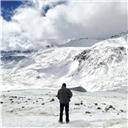
 Suzanne contemplating Mt Jefferson, Three Sisters, and Broken Top on the way down")
")
")
 View from Glacier Point. The top of Half Dome to the valley floor is ~5000 feet.")
")
")
 Little Yosemite Valley Campsite")
 Bunnell Point")
 Full moon over half dome. Unbelievably, I somehow took the next few photos with an extremely small aperture, so the photos qu")
")
 Clouds Rest to the North East.")
")
 Points if you can make out the climbers on El Cap (zoomed in below)")
 Climber descending cables route.")
")
 Our group descending to Timberline")
 Lower Multnomah Falls")
")
")
")
")
 Angle of ascent from the cables")
")
")
")
")
")
")
")
")
")
 Looking back down the cables from halfway")
")
")
|
| Comments or Questions | ||||||||||||
|---|---|---|---|---|---|---|---|---|---|---|---|---|
|
Caution: The information contained in this report may not be accurate and should not be the only resource used in preparation for your climb. Failure to have the necessary experience, physical conditioning, supplies or equipment can result in injury or death. 14ers.com and the author(s) of this report provide no warranties, either express or implied, that the information provided is accurate or reliable. By using the information provided, you agree to indemnify and hold harmless 14ers.com and the report author(s) with respect to any claims and demands against them, including any attorney fees and expenses. Please read the 14ers.com Safety and Disclaimer pages for more information.