Download Agreement, Release, and Acknowledgement of Risk:
You (the person requesting this file download) fully understand mountain climbing ("Activity") involves risks and dangers of serious bodily injury, including permanent disability, paralysis, and death ("Risks") and you fully accept and assume all such risks and all responsibility for losses, costs, and damages you incur as a result of your participation in this Activity.
You acknowledge that information in the file you have chosen to download may not be accurate and may contain errors. You agree to assume all risks when using this information and agree to release and discharge 14ers.com, 14ers Inc. and the author(s) of such information (collectively, the "Released Parties").
You hereby discharge the Released Parties from all damages, actions, claims and liabilities of any nature, specifically including, but not limited to, damages, actions, claims and liabilities arising from or related to the negligence of the Released Parties. You further agree to indemnify, hold harmless and defend 14ers.com, 14ers Inc. and each of the other Released Parties from and against any loss, damage, liability and expense, including costs and attorney fees, incurred by 14ers.com, 14ers Inc. or any of the other Released Parties as a result of you using information provided on the 14ers.com or 14ers Inc. websites.
You have read this agreement, fully understand its terms and intend it to be a complete and unconditional release of all liability to the greatest extent allowed by law and agree that if any portion of this agreement is held to be invalid the balance, notwithstanding, shall continue in full force and effect.
By clicking "OK" you agree to these terms. If you DO NOT agree, click "Cancel"...
DATES: July 3-5, 2014 RT DISTANCE: ~15 miles RT GAIN: ~9,500' CLIMBERS: Sam (Steve Climber), Keegan (AlpineDude), Jeff (SurfNTurf) RACK: 6 ice screws (1x 19cm, 4x 16cm, 1x 13cm), 3 pickets, crevasse rescue gear, 60-meter 8.5mm rope, 2 ice tools
Rough sketch of the line. Red = ascent, orange = descent.
Mt. Rainier's Kautz Route is a logical "next step" for mountaineers looking to evolve their game from hill-walking to climbing. Named for Lt. August Valentine Kautz, it follows the line Kautz took on July 16, 1857, during the first serious attempt on the mountain. Some say he even got as far as the crater rim, which qualifies as an ascent according to modern-day guiding services. Either way, Kautz never touched the true summit at Columbia Crest, and the first ascent of Rainier fell to Hazard Stevens and P.B. Van Trump in 1870 via the Gibralter Ledges.
The Kautz Glacier is rated Grade III, with two distinct chutes allowing passage through the massive Kautz Ice Cliff. It seemed like a good pairing with the Adams Glacier for a week-long trip suited to our experience level. After success on Mt. Adams, Sam and I spent a couple days recovering before heading over to Sea-Tac to pick up Keegan at 5:30 p.m. Wednesday, July 2.
Now a full three-man team, we headed straight for our awaiting room at Whittaker's Bunkhouse in Ashford, Wash., the nearest town to the Nisqually Entrance at Mount Rainier National Park. We did stop briefly at a WalMart to buy food and totally rad $10 technical T-shirts (more on this later). Whittaker's Bunkhouse - basically an upscale climber's hostel - is worth the experience, and the bagels in the morning are top-notch. We sorted gear, walked over to the Highlander pub for burgers and beer, and hit the sack for a gentleman's start the following morning.
The weather had deteriorated rapidly in the days leading up to our trip. When we were on Adams, the long-term forecast for Rainier was sunny, clear and calm. By the morning of our approach, the National Weather Service was calling for 40-50mph wind every day and snow moving in Saturday. As we were checking in at Paradise and starting up the Skyline Trail sometime around 10 or 10:30 a.m. Thursday, I gave us a 50/50 shot at reaching the top. But I kept that to myself.
A marine cloud layer made the approach humid, muggy and depressing. We were sweating as if we were hiking in Miami. As promised by the climbing ranger at check-in, we began emerging from the fog at about 6,500 feet, where we left the main Skyline Trail at Glacier Vista to drop down to the Nisqually Glacier.
The lower Nisqually looks benign, but it has a few hidden crevasses. Most parties rope up, and we chose to play it smart. Once on the glacier, a horizontal traverse leads toward The Fan, a prominent and obvious gully that grants access to the Wapowety Cleaver. A couple 40ish-degree snow sections saw us to the more moderate ridge crest. Finally, the traversing was over. We took a right and made a bee-line for the Kautz Ice Cliff.
Starting up the Skyline Trail in the soup.
Eerie.
Roping up to traverse the Nisqually Glacier.
The Fan (lower left) and most of the route to the Kautz Ice Cliff.
We never planned on reaching Camp Hazard at 11,300', as it's fairly exposed to falling rock and ice. Many safer campsites exist along the left-hand edge of the Turtle Snowfield, and our goal was to park at about 11,000'. With the day getting late, the wind increasing and clouds rolling in, we instead pitched our tents at one of the first sites we saw, somewhere between 9,500' and 10,000'. A two-man team arrived a few minutes after us and crashed the party. They were nice enough guys, they just talked A LOT, and mostly about themselves. We were slightly puzzled as to why they pitched right next to us when there were several other options within a 15-minute walk, but hey, what can you do?
The late afternoon and early evening were amazing. We melted water, made food and just generally lounged while taking in the stellar views. The sun disappeared behind a ridge around 7:30 p.m., and we retired to our tents to escape the cold. Alarms were set for 2 a.m., with the hope of being walking an hour later.
Camp on the upper Wilson Glacier, with the remaining route above.
Taking in our route on Mt. Adams from a few days prior.
Sunset at "high" camp.
The party of two got an hour jump on us and we didn't see them again. It also took us longer than expected to get packed up and ready to go, so we weren't moving until 3:45 a.m. Our headlamps were only needed for about a half-hour. A strong bootpack made the early morning routefinding a breeze, and we mostly just zoned out and trudged upward until the sunrise took our breath away.
I knew from my prior Pacific Northwest excursions what to expect, but sunrise high on a volcano will never cease to impress. The morning was wonderfully clear, with the faithful marine cloud layer below and only light winds. My camera was in rapid-fire mode at every rest break.
Alpine start.
Sunrise is a-comin'.
Goat Rocks and Mt. Adams over a sea of clouds.
Rainier's mountain shadow.
We reached Camp Hazard and the base of the Kautz Ice Cliff after about two hours of zig-zagging up the Turtle Snowfield. There's allegedly a fixed line down some Class 4 rock that allows easy passage on to the Kautz Glacier. We wasted an hour trying to find it before giving up and blazing our own way down, right up against the ice cliff itself. This line required exposure to a garbage chute of large debris directly beneath a wall of teetering seracs. We hugged the rocks to avoid the direct fall-line and made our way down and out as fast as we could manage.
On the relative safety of the Kautz Glacier, we were now staring up at the beginning of the technical difficulties: the first ice pitch. The beta we'd received said it was short (20-30 feet) and mostly snow, a simple warm-up before the more serious second pitch. We started simul-climbing without much thought. Before long, Sam, in the lead, started hitting bonafide water ice. It never got very steep (45 to 55 degrees), but it was dinner-plating like crazy. Gains were slow and laborious. My calves, still not fully recovered from the Adams Glacier and bearing the weight of a full overnight pack, were on fire. We sank a couple screws, clipped an established V-thread and topped out after a long 150-foot effort. So much for a cruiser 30-foot snow pitch.
The garbage chute we had to scamper down and across, with the looming ice cliff.
Gasping for air and massaging our calves, we stopped for a long break on the mellow snowfield between the first and second ice pitches. The second chute was reported to be much longer and more difficult, so we planned to pitch it out. Keegan and I tied onto the end of the rope, giving Sam most of the full 60 meters for his lead.
As fate would have it, the second pitch was much easier than the first. We should have pitched out the first and simul-climbed the second, instead of doing the exact damn opposite. Sam led the length of the rope high-daggering on mostly snow, built an anchor at an existing V-thread and brought us up in a few short minutes. The second half of the chute had a bit of legit alpine ice, but the dinner plates had given way to hero sticks. When the pitch began laying back and Sam ran out of rope again, he built another anchor using a picket and a 19cm screw. Keegan and I easily climbed up, wondering how in the hell our intel was so bad.
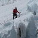
The second ice pitch.
Belaying Sam on his long lead.
Sam leading again, nearing the second anchor point.
Keegan and I celebrating success.
Either way, we were above the difficulties and only faced a 2,500' snow slog to Columbia Crest. We stopped for a while to enjoy the views and return the rope to glacier-travel mode. The wind, forecast for almost hurricane-force, still only lapped lightly at our backs. It was welcome in the increasing heat of the day.
The upper Kautz Route involves a long traverse around 14,158-foot subpeak Point Success, above the Gibralter Ledges, and eventually toward the left side of the summit crater. A few crevasses kept our attention focused. For the most part, we were able to follow an intermittent boot pack and wands installed by Alpine Ascents International. Nothing really exciting happened, just a few hours of uphill snow-walking on exhausted legs with 35-pound overnight packs. The final 500 feet was pretty brutal, as we had to detour around a giant half-mile long crevasse blocking direct access to Columbia Crest. Finally, sometime around 2:30 p.m., we staggered onto the summit.
Awesome! A long, featureless snow slog.
This has to end at some point, right?
At least the views didn't suck.
Finally nearing the summit crater and Columbia Crest.
Summit shot.
Here the wind forecast proved true. Gusts exceeding 50 mph knocked us around pretty good, and I was the only one who grabbed a quick summit shot. We'd planned for a group picture in our amazing new technical tees, but alas, it was not to be. At least the wind abated to 20ish miles per hour down in the summit crater.
Our plan all along was a carry-over of the Kautz route with a descent of the easier Disappointment Cleaver. If conditions allowed, we had been entertaining the idea of sleeping on the summit. All three of us were pretty wiped, an afternoon descent on soft snow sounded terrible, the wind in the crater wasn't too bad and we could see the wanded highway of the DC starting 50 yards away. It wasn't a drawn-out decision process. We were going to spend our Fourth of July bivying on top of Mt. Rainier. AMERICA!
The best part would be a 360-degree view of fireworks from all the surrounding cities and towns, right? Wrong. The storm forecast for Saturday rolled in early, and by 6 p.m. we were ensconced in a full-blown whiteout. We retreated into the tents to pass a very long, very uncomfortable 13 hours.
I love my Black Diamond Firstlight tent. The huge knock on it, however, is that it's prone to condensation. Even with the vents as open as we could stand with the howling storm, the inside soon became coated in ice particles. Whenever a gust would snap the tent wall, it would shoot crystals at lightning speeds into our bewildered, half-asleep faces. Sam and I basically crawled into the fetal position, back to back, to stay as far away from the walls as possible. Neither of us slept much. Keegan had his own tent and I can only assume slept like a baby. Jerk.
Camp in the summit crater.
Warm and bluebird, for now...
What a gorgeous night! I can't wait to see the fireworks!
Syyyykeeeeee.
First light came sometime around 5 a.m. We were startled to hear voices. Not just some voices, but lots of voices. We couldn't see more than 20-30 feet from our tent most of the time and we never made visual contact, but knowing people were successfully coming up the DC route obliterated any fear we had of the whiteout descent. A torturous hour of clearing rime ice off EVERYTHING, packing soggy gear and sorting the rope with mittened hands had us ready to walk down around 8:30 a.m.
The voices we'd heard - probably about three parties total - turned out to be only the vanguard of the DC army. The second we hopped on the wanded trail, we started passing group after group coming up. Even one guided team was still ascending despite the wind, snow and limited visibility. We offered encouragement and enjoyed the lighthearted descent, all worries vanished.
Sam, after a loooong night.
Selfies make everything better, even when you have to wear a hard shell inside your tent.
Morning views.
Trying to remember how our hands work.
"Wand."
Whiteouts are fun.
Oh, hey. A jump-across.
We emerged from the soup right at the top of the Disappointment Cleaver. Familiar views from my 2012 trip opened up: Camp Muir, Little Tahoma, the Ingraham Flats, Cathedral Gap. The storm up high turned out to be a lenticular cap, and the lower snow slopes had been baking in the sun all morning. Even at 10 a.m., it was like walking on 35-degree mashed potatoes. We took our time descending to the fixed ropes that traverse across the nose of the cleaver.
Once back on the Ingraham Glacier, a small uphill trudge under a minor serac band represents the end of any serious danger. We took long breaks at the Flats and Camp Muir to strip off layers, eat, drink and bask in the accomplishment. The best part? It was finally warm enough for us to show off our new baselayers.
Emerging from the cloud. (Photo by Keegan.)
Little Tahoma.
Bustling Camp Muir.
On the fixed lines across the nose of the DC.
Looking back up toward the summit.
Ingraham Flats and the Disappointment Cleaver.
AMERICA!
The Muir Snowfield should be the descent off every mountain. Long glissades led to easy plunge-stepping terrain, which led to more long glissades. We were back at Paradise early in the afternoon. After quick showers in our room at the Nisqually Lodge, we walked a weary half-mile back to the Highlander tavern, where we ran up a $110 tab on cheap beer and burgers. We realized it was time to go sometime around 8 p.m., when Keegan played "My Humps" 10 straight times on the jukebox and I lost the ability to make contact with a pool ball.
Happy Fourth of July! Good luck to the teams heading for Rainier in the coming days and weeks, it's a fine mountain in fine condition.
Thumbnails for uploaded photos (click to open slideshow):
...scenery only granted to those who dare to venture into the Pacific Northwest. Congrats on a successful two-bagger and thanks for the vicarious joys!
Heading up to Rainier right now, Kautz attempt #2. We attempted it June 27th, 2014. Any chance those vee thread anchors on the ice wall were orange/yellow accessory cord? If so, those were ours! Good job making the top in those conditions!
Caution: The information contained in this report may not be accurate and should not be the only resource used in preparation for your climb. Failure to have the necessary experience, physical conditioning, supplies or equipment can result in injury or death. 14ers.com and the author(s) of this report provide no warranties, either express or implied, that the information provided is accurate or reliable. By using the information provided, you agree to indemnify and hold harmless 14ers.com and the report author(s) with respect to any claims and demands against them, including any attorney fees and expenses. Please read the 14ers.com Safety and Disclaimer pages for more information.
Please respect private property: 14ers.com supports the rights of private landowners to determine how and by whom their land will be used. In Colorado, it is your responsibility to determine if land is private and to obtain the appropriate permission before entering the property.


 and most of the route to the Kautz Ice Cliff.")


")


 Starting up the Skyline Trail in the soup.")
 Eerie.")
 Roping up to traverse the Nisqually Glacier.")
 The Fan (lower left) and most of the route to the Kautz Ice Cliff.")
 Camp on the upper Wilson Glacier, with the remaining route above.")
 Taking in our route on Mt. Adams from a few days prior.")
 Sunset at \"high\" camp.")
 Alpine start.")
 Sunrise is a-comin'.")
 Goat Rocks and Mt. Adams over a sea of clouds.")
 Rainier's mountain shadow.")
 The garbage chute we had to scamper down and across, with the looming ice cliff.")
 The second ice pitch.")
 Belaying Sam on his long lead.")
 Sam leading again, nearing the second anchor point.")
 Keegan and I celebrating success.")
 Awesome! A long, featureless snow slog.")
 This has to end at some point, right?")
 At least the views didn't suck.")
 Finally nearing the summit crater and Columbia Crest.")
 Summit shot.")
 Camp in the summit crater.")
 Warm and bluebird, for now...")
 What a gorgeous night! I can't wait to see the fireworks!")
 Syyyykeeeeee.")
 Sam, after a loooong night.")
 Selfies make everything better, even when you have to wear a hard shell inside your tent.")
 Morning views.")
 Trying to remember how our hands work.")
 \"Wand.\"")
 Whiteouts are fun.")
 Oh, hey. A jump-across.")
 Emerging from the cloud. (Photo by Keegan.)")
 Little Tahoma.")
 Bustling Camp Muir.")
 On the fixed lines across the nose of the DC.")
 Looking back up toward the summit.")
 Ingraham Flats and the Disappointment Cleaver.")
 AMERICA!")
 Rough sketch of the line. Red = ascent, orange = descent.")