| Peak(s): |
Gannett Peak - 13809 |
| Date Posted: | 07/21/2016 |
| Modified: | 08/07/2016 |
| Date Climbed: | 07/02/2016 |
| Author: | Hoot |
| Additional Members: | Crestoner |
| Peak(s): |
Gannett Peak - 13809 |
| Date Posted: | 07/21/2016 |
| Modified: | 08/07/2016 |
| Date Climbed: | 07/02/2016 |
| Author: | Hoot |
| Additional Members: | Crestoner |
| Gannett Peak via Titcomb Basin |
|---|
|
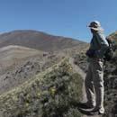
Gannett Peak (13,809') 1-3 July 2016 Partners: Nathan and Dave with Kiefer Trailhead: Elkhart Park (western approach) Camp: Titcomb Basin Distance: 43 miles Cumulative elevation gain: 13,144' (Nathan's GPS) Wyoming's Gannett Peak is generally regarded as the second or third most difficult U.S. state high point to climb after Denali due to a very long approach and technical snow climbing. The peak is well-hidden deep in Wyoming's Wind River Range and is surrounded by glaciers. I had planned to climb Gannett three years ago with Nathan and Dave, but I sprained my ankle badly two weeks before the climb and had to pull out of the trip. I did not have any partners lined up for this year's trip until both Nathan and Dave decided to join me just a couple of weeks before the long Independence Day weekend. I am so glad they joined me on this trip. Nathan and I drove from Colorado Springs to the Elkhart Park trailhead on Thursday afternoon, stopping briefly in Rock Springs and Pinedale along the way. The drive took a little over eight hours. When we arrived around 7:30 pm, there were plenty of camping sites available at the campground next to the trailhead parking area. The notorious Wind River mosquitos were out in full force at the trailhead, so we donned our head nets. But that was the only time I wore my head net during the trip. After talking with some other hikers, Nathan set up his tent and I went to sleep in the back of my 4Runner. Dave and Kiefer arrived later that evening. Our ambitious plan was to hike all the way up to Titcomb Basin on Friday, summit on Saturday, and hike out on Sunday. Since we were in no rush Friday morning, I slept in longer than usual and the three of us had a leisurely breakfast with relatively few mosquitoes buzzing around. We moved our cars to the large trailhead parking lot joining many other hikers. Before starting out, I weighed my pack with water at 39.6 lbs. Nathan's was also right around 40 lbs. Although I did not think we'd need them, we carried a 30m/8mm rope, alpine harnesses, and a little gear. We also carried food for four days in case we got weathered out one day. But the forecast looked very promising and Friday morning was beautiful and sunny. The three of us and Kiefer started hiking up the Pole Creek Trail from Elkhart Park at 7:11 am Friday morning. The Pole Creek trail starts at 9,360 feet at Elkhart Park. Titcomb Basin is only about 1,300 feet higher so the net elevation gain for our 17-mile approach was pretty modest. We gradually gained almost 1,000 feet in the first five miles of the trail up to Photographer's Point. But the excellent dirt trail never seemed steep as it traveled through mostly wooded terrain and a few beautiful open meadows filled with wild flowers. As long as we were moving on the trial, the mosquitos did not bother us. However, when we stopped to take pictures or for other purposes, it did not take long for the mosquitos to surround us. I had treated my shirt, pants, socks, and pack with Permethrin before the trip and that seemed to work well. In fact, I didn't get a single mosquito bite the whole trip. Only camping above tree line was the other key to our success in minimizing mosquito annoyance. A little beyond Photographer's Point we continued on the Seneca Lake Trail. We had one interesting creek crossing before reaching Seneca Lake. Nathan crossed on logs and rocks near the trail while Dave and I made a big jump on rocks above the trail. On our return I found a much easier crossing a little further up the creek. Nine miles up the trail after four hours of hiking we reached an overlook above beautiful Seneca Lake. We stopped there for a quick bite to eat while enjoying the views. Just beyond Seneca Lake we stepped across some well-placed rocks in the western side of Little Seneca Lake before continuing on the Indian Pass Trail. Around the many lakes along the way, the trail climbed and descended with a notable high point between Little Seneca Lake and Island Lake. Along this section we crossed a couple of small snow fields, but for the most part the trail was dry up through Titcomb Basin. We reached Island Lake a little before 1 pm after 12 miles and almost 6 hours of hiking. Island Lake is one of the most beautiful areas I have ever visited! From Island Lake we got our first view of snowy Bonney Pass where we'd be standing at dawn the next morning. We stopped briefly to refill our water before hiking around the east end of Island Lake and up to the junction of the Indian Pass and Titcomb Basin trails. As soon as we left the Indian Pass Trail, we crossed a wide fast-running creek by stepping from boulder to boulder. The skies had been growing darker and as we were hiking along the lower Titcomb Lake, it started to rain hard enough for us to put on our rain gear. Fortunately the rain only lasted about 30 minutes. The sun was out again before we reached our campsite above the north end of the upper Titcomb Lake. We dropped our packs at 3:21 pm after hiking 16.94 miles in 8 hours and 10 minutes from the trailhead. While there was a lot of water in the area, we found dry spots for our three tents in the same area where Dave and Nathan had camped three years earlier. We enjoyed the gorgeous scenery of Titcomb Basin while cooking our dinners and preparing our lighter packs for the next day's climbing. Around 7 pm it started raining again and it rained pretty steadily until sometime after sunset. I fell asleep to the sound of the rain on my tent. Saturday morning I was awake and excited to get going before my alarm went off at 2:15 am. I managed to make some coffee and woof down some cereal before we left camp. My headlamp was having issues but Dave loaned me his backup headlamp which worked much better than mine at full strength. The three of us and Kiefer started the day's climb at 3:10 am with headlamps lighting our way. It took longer than I expected for us to reach the snow-filled couloir up to Bonney Pass. In the two miles from camp to the base of the couloir, we worked our way through and around lots of water coming down the drainage. We eventually got on continuous snow which made the going easier. Nathan had a GPS track I had traced and that helped ensure we were headed in the right direction. But the general route was fairly obvious even in the dark. After 70 minutes of hiking we stopped to put on our crampons and helmets and do other things. Then we began the climb up a moderate snow slope to Bonney Pass. The couloir's slope angle probably averages around 35 degrees with the steepest section near the top. The conditions were great for crampons and ice axes, but not so good for Kiefer's paws. Kiefer has climbed many snow slopes steeper than this one so we were surprised to see Kiefer having trouble climbing. We think the previous night's rain made the surface smooth and slick. Dave had him on a long leash near the top and Kiefer slid down pulling the leash tight several times. It took us about 75 minutes to climb the couloir. We reached the top of Bonney Pass on the Continental Divide as the skies were lightening at 5:35 am, 2.5 hours after leaving camp. On the pass, I was treated to my first view of the massive Gannett Peak and the glaciers surrounding it. Gannett looked beautiful and intimidating in the early morning light. With the troubles Kiefer was having, Dave make the wise but heartbreaking decision to turn back at this point where he had done the same three years earlier. After refueling, Nathan and I wished Dave well on his return and continued on. From the top of Bonney Pass at 12,800 feet, we descended a little more than 1,200 feet onto the huge Dinwoody Glacier. The descent was quick and easy on good snow. Then we hiked across Dinwoody toward the Gooseneck Pinnacle ridge. Along the way we crossed the trench left by a huge boulder that had slid down the glacier. This may have been the same boulder Nathan and Dave witnessed sliding down three years earlier. After a break to refuel and to strip down to a single layer, Nathan and I climbed up the branch of the Dinwoody just south the Gooseneck Pinnacle ridge and below Glacier Pass. This part of the glacier contained crevasses and seracs, but we easily avoided these on our route. Along the way we met Jeff from Michigan who was climbing from the eastern approach. He was having difficulty with his crampons and I think he turned around before reaching the upper slope. Nathan and I scrambled across a short rock band to get from Dinwoody onto the "upper moat" of snow that curves across the Gooseneck Pinnacle ridge providing easy access to the Gooseneck Glacier on the north side of the ridge. At the north end of the snow moat we scrambled across a few more rocks to get onto the south edge of the Gooseneck Glacier. At this point we had the choice of climbing up the Gooseneck Glacier or climbing up a much shorter less steep snow slope to get onto the ridge. As the snow was in great shape for climbing and Nathan was game, we headed up the Gooseneck! Dave and I have quite a bit of experience climbing on snow and with the excellent conditions, I thought the Gooseneck was a relatively low-threat moderate snow climb with a slope angle averaging around 40-45 degrees. However, I would not recommend this climb as a first or second snow climb for anyone and it would be much more serious on hard snow. I led the way up on the south side of the glacier to the left of the glacial ice in its center. The slope got a bit steeper near the top as I veered to the left toward the ridge. At one point there was ice not far below the snow and near the top, the snow was a little softer than I would have liked. But overall the Gooseneck was a really fun climb. As we approached the ridge, the edge of the Gooseneck slope leveled off for an easy hike toward the "upper slope" with the bergschrund that often is the crux of the route. The upper slope was a little steeper but much shorter than what we had climbed up the Gooseneck. And the slope contained boot tracks up the center, likely from the previous day. As for the dreaded bergschrund, it was a non-issue for us. While the 'schrund was beginning to open on the right side of the slope, there was no sign of it in the center or on the left side of the upper slope. This was clearly an advantage of climbing Gannett in early July on a good snow year. We motored up the slope in good tracks and climbed onto rocks at the top which put us close to the crest of the Gooseneck Pinnacle ridge. At this point, Nathan and I let four young climbers from Jackson, Wyoming pass us on the ridge. We had passed their tents in upper Titcomb Basin early in the morning and they had made good use of our tracks up the Gooseneck. It was good to have some company up there! Above the upper slope, we climb toward Gannett's summit ridge initially on the north side of the Gooseneck Pinnacle Ridge. After a few exposed corners on snow and rock, we took off our crampons and climbed the remainder of the ridge mostly on rock along the ridge crest. From this vantage, the view of what lay ahead in getting onto Gannett's summit ridge looked pretty scary. While hiking in the day before, two climbers told us that the summit ridge snow had been uncomfortably soft for them resulting in a nail biting down climb off the ridge. They also admitted to starting out from Titcomb Basin at 6 am so we may have had 3 fewer hours of sun on the snow at this point. As I approached the summit ridge, I watched the four climbers head up without difficulty, leaving behind nice boot tracks for me! From the top of the Gooseneck Pinnacle ridge, the climb onto Gannett's summit ridge did not look quite as bad. It was only 9:30 am and the snow as still in good shape so I put my crampons back on and headed up while Nathan enjoyed the views from the ridge. The challenge of getting onto Gannett's summit ridge probably varies considerably with snow conditions. I was fortunate to have great snow which made the climb and return pretty easy for me. I encountered no difficult moves from the Gooseneck Pinnacle Ridge to the summit. But most of the way was through a "no fall" zone which required careful focused climbing. Along the summit ridge you might be able to self-arrest after a fall. But the traverse required to get on and off the ridge is above a really big drop-off and there's not much room for a self-arrest. From the Gooseneck Pinnacle ridge it took me about half an hour to reach the summit. I reached the top of Wyoming at 10:10 am after 7 hours of climbing from our camp in Titcomb Basin. The views from the summit were spectacular, especially with all the surrounding glaciers. There was a bit of haze in the distance, but I could just make out the Grand Teton to the northwest. The group of four climbers and I exchanged photos during my 10-minute stay on the summit before I started back down ahead of them. Just below the summit, I talked for a while with a solo climber from San Francisco who also had come from Titcomb Basin. He had climbed up the Gooseneck the day before but did not summit due to altitude sickness. I'm pretty sure that the six of us were the only ones to summit that day and we all did so around 10:00 am with a very early start in Titcomb Basin. Retracing my steps along the summit ridge and then back down to the top of the Gooseneck Pinnacle ridge was not a problem as the snow was still in good shape for secure steps. Nathan and I hiked back down the Gooseneck Pinnacle ridge with the other climbers. While descending the upper slope of the ridge, I checked out the bergschrund which was only open about 1-2 feet wide for about 10 feet. It looked 10-15 feet deep from what I could see. Below the upper slope, we decided to descend along the Gooseneck Pinnacle ridge which the other climbers did ahead of us. This was an easier and safer descent than going back down the Gooseneck Glacier would have been. Hiking down the short snow slope on the north side of the ridge briefly put us back on the glacier before we descended on rocks to get back on the snow moat. From there we pretty much retraced our approach route along the moat and then down onto the Dinwoody Glacier. As we re-crossed the Dinwoody shortly after noon, the skies clouded up, the wind kicked up, it started to rain and we heard thunder rumbling not far away. Fortunately, this didn't last long and the sun was back out for our climb 1,200 feet back up to Bonney Pass. We made our own switchbacks up the slope. I felt comfortable leaving my ice axe on my pack and just using my trekking poles and crampons to climb this slope. It only took us about 70 minutes to re-cross Dinwoody and climb back up to the pass. Back on Bonney Pass we briefly got snowed on before the sun returned for the rest of the afternoon. We retrieved some water which Dave had left for us on the pass in the morning. This was really nice as I had drunk all of the 100 ounces of the water I had left camp with in the morning. It was tempting to glissade down into Titcomb Basin from the top of Bonney Pass as the other climbers had done ahead of us. But Nathan and I hiked most of the way down the couloir with the now soft snow annoyingly balling up under our crampons. When I was most of the way down, I slipped and fell down and decided to just stay seated for a nice long glissade. Nathan followed glissading in my track. From the top of Bonney Pass, it took us two hours and 15 minutes to hike back to camp. We dropped our packs in camp at 3:51 pm for a 12 hour and 40 minute round trip of 9.64 miles with a cumulative elevation gain and loss of 5691 feet (according to Nathan's GPS). We briefly considered packing up and moving our camp a few miles down the trail as we had plenty of daylight remaining. However, we reasoned that doing so would require breaking camp twice and likely camping with the mosquitos. Instead, I took a nap, ate two freeze dried dinners, and got a long night's sleep which I think was definitely the best option for me. Sunday morning Nathan and I packed up in the dark and left camp before sunrise at 5:28 am. I wasn't looking forward to the 17-mile hike out, but it wasn't as bad as I expected. Nathan is a faster hiker than me so I was usually well behind him on the trail. We saw and talked to lots of hikers along the trail. Many people were camped out around the lakes. Several hikers were eager for beta on Gannett. A few of these were state high pointers with shiny new ice axes who did not seem to fully appreciate the challenge that lay ahead of them. Hopefully we convinced most of them to start very early from Titcomb Basin. The morning light made for some nice photos including a particularly good shot I got of Island Lake. As the miles went by, I got in the rhythm of adjusting my pack straps to alternate shoulder pain and hip pain, but it never got too bad. My boots (Asolo Drifter GVs) worked amazingly well for me for the full 43 miles on the trail, on snow with crampons, and through water. I hiked the last couple of miles in light rain without bothering to put on my rain jacket. After 7 hours and 43 minutes of hiking from our camp, I returned to the trailhead at 1:15 pm. On our way out, Nathan and I stopped at the Great Outdoor Shop in Pinedale to leave a conditions report for other climbers. Our conclusion was that conditions could not have been better for climbing Gannett! We stopped for a late lunch in Rock Springs and then again for dinner in Cheyenne before getting back to the Springs and home by 11:00 pm. In retrospect, Gannett was the most rewarding climb I have ever done! The approach alone makes it one of the toughest, certainly right up there with Rainier and the Grand Teton in terms of level of effort. While the actual climbing on our route was not particularly technical, only requiring an ice axe and crampons, it was challenging and fun. And the scenery on the approach, in Titcomb Basin, and on the glaciers, was about as good as it gets. Some might want to take a few more days than we did to enjoy the area, but if I were to climb Gannett again from the west, I'd do the same way! Thumbnails for uploaded photos (click to open slideshow):  Car camping near the Elkhart Park trailhead")
 Elkhart Park trailhead")
 Pole Creek Trail")
 View from Photographer's Point")
 View from the Pole Creek Trail")
 Our first creek crossing")
 Dave, me and Nathan above Island Lake")
 Sandy Beach on Island Lake - not too crowded")
 On the Titcomb Basin Trail")
 Our second creek crossing")
 Trail in Titcomb Basin")
 Camp in Titcomb Basin with Bonney Pass on the left")
 Dave and Kiefer starting up to Bonney Pass")
 First view of Gannett from Bonney Pass")
 Looking back down the Dinwoody with 4 climbers barely visible across the trench left by a sliding boulder")
 Nathan on the upper moat of snow")
 Snow slope leading up to the Gooseneck Pinnacle Ridge (we descended this way)")
 Headed up the left side of the Gooseneck Glacier")
 Climbing the Gooseneck Glacier")
 The steepest section of the Gooseneck Glacier")
 The upper slope with the bergschrund barely open on the right")
 Nathan climbing the upper slope near where the bergschrund will cross")
 Transitioning from snow to rock above the upper slope")
 The Gooseneck Pinnacle")
 Lots of air below the traverse from the Gooseneck Ridge to Gannett's summit ridge")
 Climbing onto Gannett's summit ridge")
 Standing on top of Wyoming!")
 Bonney Pass (left), Mt Woodrow Wilson (center), upper slope with bergschrund visible and the Gooseneck Pinnacle Ridge from th")
 Returning along the ridge - looking right ...")
 ... looking left ...")
 ... I'll just look staight ahead!")
 The barely open bergschrund on the upper slope")
 A crevece on next to our route on the Dinwoody Glacier")
 Headed back across the Dinwoody Glacier toward Bonney Pass")
 Titcomb Lakes from Bonney Pass")
 Looking down the couloir into Titcomb Basin from Bonney Pass")
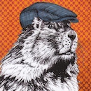
 This guy was after our food but thwarted by a plastic bag placed on top of a boulder")
 Parting shot of Titcomb Basin")
 Golden columbine???")
 Island Lake")
|
| Comments or Questions | |||||||||||||||
|---|---|---|---|---|---|---|---|---|---|---|---|---|---|---|---|
|
Caution: The information contained in this report may not be accurate and should not be the only resource used in preparation for your climb. Failure to have the necessary experience, physical conditioning, supplies or equipment can result in injury or death. 14ers.com and the author(s) of this report provide no warranties, either express or implied, that the information provided is accurate or reliable. By using the information provided, you agree to indemnify and hold harmless 14ers.com and the report author(s) with respect to any claims and demands against them, including any attorney fees and expenses. Please read the 14ers.com Safety and Disclaimer pages for more information.