Download Agreement, Release, and Acknowledgement of Risk:
You (the person requesting this file download) fully understand mountain climbing ("Activity") involves risks and dangers of serious bodily injury, including permanent disability, paralysis, and death ("Risks") and you fully accept and assume all such risks and all responsibility for losses, costs, and damages you incur as a result of your participation in this Activity.
You acknowledge that information in the file you have chosen to download may not be accurate and may contain errors. You agree to assume all risks when using this information and agree to release and discharge 14ers.com, 14ers Inc. and the author(s) of such information (collectively, the "Released Parties").
You hereby discharge the Released Parties from all damages, actions, claims and liabilities of any nature, specifically including, but not limited to, damages, actions, claims and liabilities arising from or related to the negligence of the Released Parties. You further agree to indemnify, hold harmless and defend 14ers.com, 14ers Inc. and each of the other Released Parties from and against any loss, damage, liability and expense, including costs and attorney fees, incurred by 14ers.com, 14ers Inc. or any of the other Released Parties as a result of you using information provided on the 14ers.com or 14ers Inc. websites.
You have read this agreement, fully understand its terms and intend it to be a complete and unconditional release of all liability to the greatest extent allowed by law and agree that if any portion of this agreement is held to be invalid the balance, notwithstanding, shall continue in full force and effect.
By clicking "OK" you agree to these terms. If you DO NOT agree, click "Cancel"...
2016.05.30
Stammberger Ledges/North Face ski descent
~4,800' Vertical
~7.75 Miles
Quite a bit late getting this thing written up, but I'd lost all my photos from the day and lost interest in writing one up last year. Been looking at objectives for this spring, so I scrounged up some of Jordan's pictures from the day, and with quite a bit of free time, I figured why not.
In 1971 few people knew the secret of Maroon Bells snow, but Stammberger did. On June 24 he cramponed up the north face of North Maroon Peak (the north Bell), donned his planks, and skied back down. Even by today's standards the descent wasn't easy: Stammberger fell over a 15-foot cliff, and skied a narrow section exceeding 50 degrees. Moreover, he used no ropes and had no support team. Stammberger's feat amazed the locals and was trumpeted in the Aspen newspaper. Yet as with the coverage of Bill Briggs's Grand Teton ski that same spring, the Maroon Bells ski descent was too far from North American ski reality to receive much mainstream press. - Lou Dawson
Fresh off my success on Pyramid the week prior, Jordan messaged me about North Maroon for the following weekend. We made the drive to Aspen, got a couple hours sleep in the parking lot, and started up the dry trail towards North Maroon. We were able to boot a short section of steeper terrain across the creek before finally putting skis on for the traverse and final climb into the basin.
We arrived in the basin before the sun rose, and we were confident we'd make it up with plenty of spare time before the face warmed up too much. Funny enough, since we got into the basin before first light, we didn't get to properly scout the face. We had cut left too early, and were faced with a perplexing maze of impassable cliffs. We'd looked at the beta, and while we'd read about some possibly sketchy sections, these cliffs looked way spicier than they should have been. We started to climb up what looked like the easiest ways up one of the chimneys, but skis on the pack quickly made us abort before making too much progress. Without a rope, that was probably a good thing. We waste over two hours poking around before finding the correct (and obvious) way up. At least we were treated to a nice sunrise.
I was worried that we FUBARed this trip. We should have been close to the summit by now. In addition to wasting so much time dicking around like a confused sloth on a glacier, the warming snow would further slow our progress up the face. I was ready to call it a day, but Jordan was still hopeful. So we continued on.
We wallow up softening snow, with no further routefinding snafus. It was pretty tiring climbing though, and with the sun beating down, we were racing the clock. Overripe corn isn't the most enjoyable to ski, not to mention the threat of wet slides that could sweep us over the many cliff bands on the face. We make it to the summit before having to take the Nope Train to Fuckthatville, albeit a bit later than I'd have liked. I was skeptical at first, but we made it. It's almost like Jordan knew we would!
Without wasting too much time, we head down. There was good snow higher up, but surprisingly, a slushy surface hid a section of very firm snow that I wasn't prepared for. I lose control and slide face first for maybe 50 feet before coming to a stop. Holy cow. THIS IS NO-FALL TERRAIN FOR CHRISTS SAKE. WTF WAS THAT??? Jordan got some photo evidence. I insisted he delete it immediately.
We retrace our booter back to the basin, where the snow was definitely much too slushy, just happy enough to complete the line despite a couple hiccups.
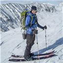
My friend Ben happened to be showing some family the area that day.
The proper route in green, and the various cliffs we poked around on
My GPS Tracks on Google Maps (made from a .GPX file upload):
Just read this and was bragging about you last night to my buddy Tony telling him about you skiing the Elks last spring. I remember you telling me about this on our drive up to the Gores last summer. Beautiful and stunning!
I happy to see those stickers are getting around!!! That's the first one I've seen seen since they were made. Thank you Darrin!
Caution: The information contained in this report may not be accurate and should not be the only resource used in preparation for your climb. Failure to have the necessary experience, physical conditioning, supplies or equipment can result in injury or death. 14ers.com and the author(s) of this report provide no warranties, either express or implied, that the information provided is accurate or reliable. By using the information provided, you agree to indemnify and hold harmless 14ers.com and the report author(s) with respect to any claims and demands against them, including any attorney fees and expenses. Please read the 14ers.com Safety and Disclaimer pages for more information.
Please respect private property: 14ers.com supports the rights of private landowners to determine how and by whom their land will be used. In Colorado, it is your responsibility to determine if land is private and to obtain the appropriate permission before entering the property.


")
")
")
")
")
")
")
")
")
")
")
")
")
")
")
")
 My friend Ben happened to be showing some family the area that day.")
 The proper route in green, and the various cliffs we poked around on")
")