| Peak(s): |
California Peak - 13,854 feet |
| Date Posted: | 04/15/2017 |
| Modified: | 04/18/2017 |
| Date Climbed: | 04/10/2017 |
| Author: | cloudkicker |
| Additional Members: | IanWright, Maverick6981 |
| Peak(s): |
California Peak - 13,854 feet |
| Date Posted: | 04/15/2017 |
| Modified: | 04/18/2017 |
| Date Climbed: | 04/10/2017 |
| Author: | cloudkicker |
| Additional Members: | IanWright, Maverick6981 |
| Sometimes the best sports drinks are 90 proof |
|---|
|
Peak: California Peak (13,849�) Distance: ~11 miles Vertical: ~4,850ft Time: 6:15AM-7:00PM at a casual pace. (Summit @ 2:45PM) Trailhead: Zapata Falls Campground, elevation 9,050ft Route: West Ridge  Strava Intro & Getting There:We've had some decent luck knocking off a few Centennial 13ers this year, beginning with a climb to the summit of Silverheels on New Years Day. Spying favorable forecasts for our staggered Sun-Mon weekend, I put together a shortlist of target peaks and started messaging potential partners. My buddies Chad and Ian agreed to come along, and our shortlist quickly narrowed to two 13ers in the Sangre de Cristo range: Marble Mountain A (great report from Tornadoman in March) and California Peak. California seemed too alluring. The West Ridge route is relatively safe this time of year, and unlike other area climbs it doesn't require an approach up a road. In fact, the Zapata Falls trailhead can be reached year round and features a nice campground with sites overlooking the San Luis Valley. This is the same trailhead that is used to access the backside of Ellingwood Point above the Zapata Lakes. We had our peak picked out, and the forecasted high on the summit was 25 with light winds. A snowstorm a week prior had dumped about 2 feet of snow on the range, but by Friday the Colorado Avalanche Information Center greenlit all ranges in the state indicating the avalanche risk had dropped back to low. Our game plan: drive up Sunday afternoon, set up camp before dark, hang out for awhile after dark, and then prepare for an early start. The drive went uneventfully. We stopped in Walsenburg for some gas and a quick bite. Chad got his first look at the Spanish Peaks, marveling at their prominence. Last time he came this way it was dark and he had no clue they were there. I gotta say La Veta Pass is really scenic and I enjoy it more than many of the other paved routes that escape the front range. When we reached the campground, only a handful of other people were around. Day use parking lot was empty and only 4 or 5 other sites were taken. I discovered campsite 13 was open, the same one I camped at last summer. This one's my favorite, the fire pit is on top of a hill that looms over the trees affording glimpses of the north. Ian pulled up shortly after. It was around this time that we decided to whip out our Bulleit Bourbon. Neither Chad nor I planned this, but we had both bought identical bottles and were double stocked for the trip.  We headed down to the trailhead and shot the shit while the sun went down.    We eventually made our way back to the campsite, where (to the chagrin of nearby campers) the more musically inclined people in our trio decided to start belting out tunes such as "Wonderwall" by Oasis. After a few such duets and bromancing moments, we all started to wind down and hit the hay. I remember having a dream that we were tramping up and around the Tenmile Range with some skier friends and I accidentally dipped my feet into an alpine lake, causing my toes to freeze. I woke up in the middle of the night with cold toes and feet despite being snug inside my 0 degree sleeping bag. At least all digits were dry though. A couple more fitful hours tossing and turning, and suddenly the alarm chirped... it was already 5am. I got dressed, had my first breakfast of clif bar and cold brew, and was ready to go. Chad and Ian enjoyed a breakfast beer and then we were off, departing the campsite around 6:15am. The Climb: ") The Zapata Lakes trail was pretty bare on our way up, aside from a few thin patches of snow lingering in the shade.   Not far in, the trail passes under some cool crags consisting of that awesome Crestone conglomerate many climbers know and love. Seeing all the knobs and potential handholds on this rock had me itching for another scrambling climb in the Sangres range. Alas, but our route today would consist solely of class 1 and class 2 hiking. Another time! A little over 2 miles in, the trail winds around a ravine and crosses a small drainage bed. This creek leads up into California Gulch and is the first sign that our turn off is near. Before we knew it, we were at the junction between the Zapata Lakes trail and N Fork South Zapata Creek. Look for an Aspen to your left in a small opening between the trees. The tree is marked "North fork trail". This is where you will leave the Zapata Lakes trail and begin the steepening ascent towards California's West Ridge. By now we had gained at most 1500ft into a 4900ft day, yet we already covered nearly half the miles from trailhead to summit. Soon enough... it gets real.  We took our first long break at this junction to replenish carbs and enjoy more "sports drink". Peering through the trees, I couldn't locate any more bare ground. I decided to put on my snowshoes while Chad and Ian opted to continue carrying theirs. At this point I'd say they made the right choice. Carrying on, we no longer had a visible trail at our feet to guide us through the forest. A little bit of route finding was necessary to keep our bearings, but with the help of topo maps we didn't have any real issues. At this point the main idea was to head "up" and follow the crest of the hill. Eventually through some openings in the brush the entrance to the base of the Gulch became apparent above and to our left. These openings also brought in more sun which meant there were more patches of bare trail to navigate. "OFF WITH HIS SNOWSHOES!", the imaginary tyrant queen commanded.  Snowshoes strapped back on to my pack and boots a-ready, we veered left and continued up some more. Soon our path reached the base of California Gulch, at approx 11,240ft. When I mapped this route, I traced two possible ascent paths for us to choose from. One would follow the previously mentioned drainage bed gently up and through the Gulch, with towering slopes at left and at right. This drainage bed had looked alluring to follow when studying the slope shading enabled Caltopo, especially considering how barren the drainage bed was. However, when we reached the base of the Gulch we knew we couldn't follow this path up any further. Less than 100 feet up the gulch, we spotted telltale signs of avalanche danger: rollerballs and pinwheels streaking the northern aspects of the West ridge all the way down to the drainage bed, continuing as far as the eye could see. Given that the temperature would reach high 30s at and below treeline today, wet slides were definitely a concern. Even if the snow held on our way up, it would certainly be problematic coming down. So, rather than hold our breaths and attempt to maneuver safely below and through the obvious terrain traps, we decided to take a sharp right and UP, in an effort to gain the ridge as early as possible. I put my snowshoes back on simply to have some teeth below my feet to keep me steady through the steepness. For about the first 100ft of vertical, the slope exceeded 35 degrees. Chad and Ian tried booting it up this slope for a little bit and eventually realized they needed their microspikes. Our ascent found us submerging back into tree cover as we reached the ridge. The base of the Gulch had teased us with the lack of trees along the drainage bed. Indeed, we still had a lot of steep climbing to tackle before reaching treeline. I'd almost say that the crux of this route is this steep stretch. To reach treeline from the base of the gulch, you have to gain 800ft in a half a mile! And of course, a healthy dose of this gain involves bushwhacking and dodging under or around fallen or leaning trees. Sometimes you just have to suck it up and slog it up the slope.  The effort required to reach treeline would have been a little disheartening if I had attempted this route solo. Luckily I had excellent company on this day, and we all toed the fine line between egging each other forward and allowing each other the quick pauses to gulp in air & water. About halfway up the 800ft of tree-suck, we found a short flat spot with a perch and took another bourbon & carbs break.   On our way again! A faint trail appeared at our feet, marked by the occasional cairn and red ribboned tree. Even without these signs, route finding wouldn't have been an issue. We knew that we were on the right track, following the ridge straight up.  FINALLY! After a laborious half mile, the trees began to thin and disappear altogether. Even better... above treeline there was hardly a breeze on the mountain! We continued about 100ft higher and found a dry section that would be perfect for another break, extended edition. I stashed the snowshoes in a visible place, switched to microspikes, ate some Lifesaver Gummies, and indulged in the vices again.   By now, we had ascended above 12,000ft. There was 1,800ft left to make summit, but it seemed so doable to us now that we'd escaped the trees. A point loomed ahead and well above us which at the time seemed like the summit. We later found out that this point was a little short of the true summit, and I have hence named it Point 13 thousand-NotSummit-and-1.    The bourbon buzz and sugar high eventually sent us moving again towards our objective. It was at this time that Chad announced he already drank all 3 liters of the water in his reservoir. Not good news considering how much "up" we had left, but we continued nonetheless. The ridge flattened out for a little bit. We knew staying on the ridge would take us to the right and add more miles than necessary, so we cut up and slightly left, approaching the uppermost hump guarding the summit from the west ridge. At approximately 4.5 miles in and 12,750ft above sea level, we were at the base of the final slope. 1,000ft or so remain with about a mile left to the summit. Our pace started to slow the higher we went, but the good news was that the "summit" started to get closer and closer. The wind had picked up by maybe 10mph from the west but was still a non-factor at our backs. I had plenty of water left so I let Chad take some from my 25oz polar squeeze.    Though I maintain that the 800ft of tree-suck was some of the hardest climbing of the day, the remaining 1,000ft was hard as well. The dehydrating effect of the bourbon finally started to kick in, and our muscles weren't as happy to cooperate as they'd been earlier in the day. I found the best way to overcome this last slope was to split it into 3. From the base I was able to locate an interesting looking rock about 1/3 of the way up, as well as some ribbons of exposed dirt 2/3 of the way up. I decided to make each 1/3 my mini objective so to not get too overwhelmed by the whole thing. I really should have split this area into 5 because once I reached what had earlier looked like the top, all I found was, you guessed it... more endless slogging to go. It was well past the 2 o'clock turnaround time and we were still far above the Hillary step. Oh wait... wrong mountain. Ian surmised that despite the summit being nowhere in sight, we weren't too far away from the top. Thank goodness. I think the three of us were starting to run out of steam and just wanted to be heading down by now so to make it back to the main trail before sunset. We kept going, of course. We discovered to our delight that after climbing 5/3 of the way up the Slope Of Endless Annoyance to Point 13-thousand-NotSummit-and-1, we reached the summit ridge! A hop, skip, and jump ahead of us was the summit. We knew that we had nary 5 minutes left of climbing and maybe 80ft more to gain, and we'd be there!    On the summit the wind still wasn't that bad, and it was warm enough to take our gloves off and enjoy our summit beers. Chad popped open a tall boy with 11.5% abv that an online hiking buddy from out East had sent him. My beer was 8.3% too... whoops. Strong beers for a strong climb.   Ian told a great story about how he once drunkenly climbed a mountain wearing a pirate costume only to have to fend off an aggressive bear with a toy cutlass. Some day they will make a biopic about this guy's doings ala Secret Life of Walter Mitty.  About 45 minutes of time on the summit, we snapped a few more pics and videos, and it was nearly 3:30pm. Time to head down. On our way down the snow wasn't holding like it had been heading up, but the plunge stepping was (for the most part) pretty pleasant. There were occasional instances of postholing into hidden rocks, but luckily none of us turned an ankle. We made it back down to treeline & my snowshoes in about an hour, just a fraction of the time that we had required going up. Another short break and I decided to strap my snowshoes on my back and just stick with the microspikes. We moved more quickly than expected back down the 800ft of tree-suck, yet it was safe going the entire way. I snapped a few pictures at the base of California Gulch intending to share them with you guys, but I discovered after the fact that large portions of my photos and GPS tracks had corrupted thanks to me butting up too closely to the limits of my measley 32GB iPhone drive. Oh well. We lost our tracks heading back down to the main junction but luckily had enough of an idea where to go that eventually we found them again and reached the junction without incident. Spikes off, another swig of bourbon, and it was time to head down a real trail again. For the most part the last 2.5 miles back to the trailhead were performed on autopilot. There were however some spots where the thin snow patches had iced over, and some of these patches were on narrow trail with steep drop offs to the side. We took care in these places but otherwise cruised on back down.  We reached the trailhead around 7pm, right as the sun began to set. I had hoped for more time to soak in these views again, but we had to take down our camp and prepare for the hours long drive back to Denver. I could barely keep my eyes open but somehow we made it back, thanks to Chad taking over the driving duties the last 45 minutes. What I learned:
|
| Comments or Questions | |||||||||
|---|---|---|---|---|---|---|---|---|---|
|
Caution: The information contained in this report may not be accurate and should not be the only resource used in preparation for your climb. Failure to have the necessary experience, physical conditioning, supplies or equipment can result in injury or death. 14ers.com and the author(s) of this report provide no warranties, either express or implied, that the information provided is accurate or reliable. By using the information provided, you agree to indemnify and hold harmless 14ers.com and the report author(s) with respect to any claims and demands against them, including any attorney fees and expenses. Please read the 14ers.com Safety and Disclaimer pages for more information.
 Sports Drink! At least one of those bottles would \"disappear\" by the end of the night.")
")
 Pretty sunset!")
 Moonrise, 24 hours before the full moon. We had intended to hike up to Zapata Falls but ran out of sunlight. It's totall")
 Moonset over campsite 13.")
 Wakey wakey bourbon and bakey! (The bacon is a lie. Sadface.)")
")
")
 The marked Aspen at the trail junction. Sorry for low res. Original photo corrupted.")
 Views of the neighboring valley through the trees.")
 800ft of tree-suck.")
 Badass krummholz and a badass climber.")
")
")
 Distant: Point 13 thousand-NotSummit-and-1")
")
 Already so high")
")
 Nothing like a good sports drink when it's prime climb time")
 At the base of Point 13 thousand-NotSummit-and-1")
 Are you tipsy yet? Am I?")
 Finally, we're high enough to see the Crestones")
 A wild summit has appeared!")
 Ian & Chad make summit ridge")
 Sand Dunes elevation at base: 7,520ft MSL. Summit ridge elevation: ~13,800ft.")
 Blanca Group from summit. Snapchat app shorted me 15ft but who cares?")
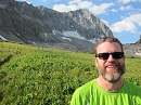
 Summit selfie.")
 I'm pretty sure this brewery took this name just so people would take summit pictures with their beers.")
 2nd pretty sunset in a row!")
")
")