Download Agreement, Release, and Acknowledgement of Risk:
You (the person requesting this file download) fully understand mountain climbing ("Activity") involves risks and dangers of serious bodily injury, including permanent disability, paralysis, and death ("Risks") and you fully accept and assume all such risks and all responsibility for losses, costs, and damages you incur as a result of your participation in this Activity.
You acknowledge that information in the file you have chosen to download may not be accurate and may contain errors. You agree to assume all risks when using this information and agree to release and discharge 14ers.com, 14ers Inc. and the author(s) of such information (collectively, the "Released Parties").
You hereby discharge the Released Parties from all damages, actions, claims and liabilities of any nature, specifically including, but not limited to, damages, actions, claims and liabilities arising from or related to the negligence of the Released Parties. You further agree to indemnify, hold harmless and defend 14ers.com, 14ers Inc. and each of the other Released Parties from and against any loss, damage, liability and expense, including costs and attorney fees, incurred by 14ers.com, 14ers Inc. or any of the other Released Parties as a result of you using information provided on the 14ers.com or 14ers Inc. websites.
You have read this agreement, fully understand its terms and intend it to be a complete and unconditional release of all liability to the greatest extent allowed by law and agree that if any portion of this agreement is held to be invalid the balance, notwithstanding, shall continue in full force and effect.
By clicking "OK" you agree to these terms. If you DO NOT agree, click "Cancel"...
Theres very few trip reports on Pennsylvania Mtn (despite it being one of the lowest and easiest 13ers), so I thought I would add one from the new Pika Trail TH that the Mountain Area Land Trust built recently. To get there, here are the directions from their website. Note, even though the google maps address lists it as Leadville (when its on the Alma side of the range), google maps puts you perfectly on the TH.
Directions to the Pika Trail
From Fairplay:
Head northwest on Highway 9 and continue 1,8 miles.
Left on Sacramento Creek Road and continue 4.9 miles.
Right on County Road 14A and continue 1.3 miles
Right on Purnes Place, use 2nd entrance to Prunes Place and continue 0.6 miles.
First Right onto Hermit Court/Prune Court and continue 0.1 miles.
Park at sharp bend in Hermit Court/Prune Court, 858 Prunes Place, Fairplay, CO 80440.
Using Google Maps?
If you are using Google Maps, please use the following address to get to the Mountain Area Land Trust's property and the Pika Trailhead,
741 Hermit Court
Leadville, CO 80461
The trailhead is a pull out and a small lot off the side of the road. Its marked with "858" as the address, and there is a small sign that designates it as the correct TH. Park county roads guy told me that they plow the roads you use to get to the trailhead all winter. When I went, the roads were plowed, but they were gravel and icy. But still very 2WD safe, just have to be careful.
Trailhead
So once I got there, I headed off onto the trail. The trail is marked by blue diamond markers on the trees, spaced about every 100 yards or so. First 50 yards of trail
The trail was well broken, however, many people had clearly went off trail. I spent a few minutes following several sets of footprints that ended up heading the wrong direction. And then I started postholing about knee deep. So I turned back, and located a blue diamond after some more postholing. I really wish I had brought my snowshoes here. After getting back on track, I stayed with the main trail for about 0.8 miles.
Good trench
In the areas without snow, the trail was clearly well built and looked to be class 1. Once I started breaking treeline, I hit three cairns. First cairn at treeline
The third cairn is the important one, its the turnoff for Pennsylvania mountain. It splits, and the right trail heads towards the summit. I THINK the left trail puts you back into the neighborhood at a different road.
3rd cairn for turnoff
Turnoff for Pennsylvania
Head for the southeast ridgeline, there was quite a bit of patchy snow but at least up here it was only a couple inches deep. There are quite a few willow patches also, but by heading towards the ridgeline you avoid most of them. I also found the trail went very faint, but there were occasional cairns and previous footprints. In any case, the route at this point is obvious, head for the first bump on the ridge (PT 12,142)
Heading for ridge
At the top of the first bump, keep heading upwards.
First bump on ridge
Looking north, you can see some active mining on the north side of pennsylvania. I did some research, and Pennsylvania has been mined for gold since the late 1800s until the present day. In 1938 they found an 11 ounce nugget, and in 1990, a 8 ounce nugget called the Turtle nugget. Active mining to north
There are also several old prospect mines scattered along the ridge. Mining dig
So after hitting the first bump, I continued upwards towards the next one False summit
Then I found about 50 small metal tags that were firmly nailed into the ground. I think they must be for environmental studies, as I found out that Pennsylvania mountain is used for that frequently. Maybe someone can tell me what they mean... marking individual plants that grew here?
Metal tags?
Onward I plodded, thankful for the nice tundra. It reminded me of Mt Helen, with its continual steady slope.
More uphill
Right as I reach the top of the slope and see a cairn, I think wow that was easy. But then I see the real summit lies about a half mile further away. I was on point 12,871.
False summit
Staying on the south side of the plateau, I followed a few cairns towards the real summit. Heading towards real summit
Near the real summit, there are some ruins of mining buildings, and another pit. Mining ruins
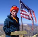
The real summit is a very broad and boring spot, but at least it had a nice windbreak built, but it was filled in with snow.
Summit
Looking north, one gets a good view of London, Buckskin and Loveland mountains. Looking north
Looking southwest, theres a good view of Gemini, Dyer, and Evans B. Looking southwest
The wind was pretty strong at the summit, so I didn't stay long. I decided to head straight across on the descent, bypassing point 12,871 and the 100 feet of regain. I contoured below the point, and regained with the southeast ridge. I also enjoyed a few glissades on the way down.
Heading back, shortcut
Next to some ruins, I found an interesting piece of metal. Marked "Navy" I assume it was a can of navy beans enjoyed by some miners. Of course, it could be a piece of a navy ship that somehow ended up in colorado Bean can?
I headed back down, enjoying the beautiful weather for Colorado mid December. Heres an approximate map of the trail, I took off the parts where I bumbled around in the woods. Total distance was 5.8 miles and 1,600 feet of gain. I would highly recommend this hike as a good place to take friends/family who can't hike more strenuous 13ers or 14ers, or just as a nice easy hike. The trail (when it was not under snow) looks very class 1. And once off the trail, its very nice class 1 tundra hiking with a few short stretches of class 2 talus.
map
Thumbnails for uploaded photos (click to open slideshow):
Many thanks for sharing your illustrative report with me! That certainly encourages me to try a winter ascent to the mountain sometime in February when the daylight hours increase.
The details about this climb and the pictures are great. Did this hike on Memorial Day and only saw 4 other people and they all came from the other direction as we were the only car parked at the beginning of this way up. We couldn€„˘t find the trail after the picture €œheading for ridge€ above but saw a guy coming towards us so followed his footsteps. Lots of willows and some snow to deal with but once we got out of the willows we just went straight up following some cairns. I€„˘m guessing this is a relatively new trail as there is the framework of a big new sign at the beginning and that it€„˘ll be better marked through the willows later this year.
Caution: The information contained in this report may not be accurate and should not be the only resource used in preparation for your climb. Failure to have the necessary experience, physical conditioning, supplies or equipment can result in injury or death. 14ers.com and the author(s) of this report provide no warranties, either express or implied, that the information provided is accurate or reliable. By using the information provided, you agree to indemnify and hold harmless 14ers.com and the report author(s) with respect to any claims and demands against them, including any attorney fees and expenses. Please read the 14ers.com Safety and Disclaimer pages for more information.
Please respect private property: 14ers.com supports the rights of private landowners to determine how and by whom their land will be used. In Colorado, it is your responsibility to determine if land is private and to obtain the appropriate permission before entering the property.


 Trailhead")
 First 50 yards of trail")
 Good trench")
 First cairn at treeline")
 3rd cairn for turnoff")
 Turnoff for Pennsylvania")
 Heading for ridge")
 First bump on ridge")
 Active mining to north")
 Mining dig")
 False summit")
 Metal tags?")
 More uphill")
 False summit")
 Heading towards real summit")
 Mining ruins")
 Summit")
 Looking north")
 Looking southwest")
 Heading back, shortcut")
 Bean can?")
 map")