| Peak(s): |
Mt. Sneffels - 14,155 feet |
| Date Posted: | 08/19/2018 |
| Date Climbed: | 08/15/2018 |
| Author: | cnlevan |
| Peak(s): |
Mt. Sneffels - 14,155 feet |
| Date Posted: | 08/19/2018 |
| Date Climbed: | 08/15/2018 |
| Author: | cnlevan |
| Sneffels Standard Route - Solo |
|---|
|
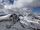
My friend and I drove down to Ouray from Grand Junction on Tuesday afternoon 08/14 intending to camp at Amphitheater Campground, but despite the fact that it was a Tuesday, the campground was full, so we headed up the Yankee Boy Basin Road (Camp Bird Road / CR 361) hoping to find a spot in one of the further up campgrounds or find somewhere on the side of the road not on private land (good luck). Angel Creek Campground is closed due to some hazard trees (or something like that) with no pending re-opening. So we continued up just a little more to Thistledown Campground. All of the drive in sites were full, but Thistledown has 3 "walk-in" campsites. You just walk all your stuff up to the site about 100-200 yards and park in a designated separate spot. This is actually much nicer, because it feels more secluded, almost like primitive camping.  I woke up on Wednesday morning at 3:45 am and hit the road at about 4:15 am, I was driving my Dad's Jeep Rubicon so I headed up to the 4wd TH. I definitely agree that this road is high-clearance/4wd/short wheelbase vehicle dependent, but the Jeep did all the challenging parts like a charm and I was at the upper TH (called Blue Lake's Trailhead) just before 5:00 am. I had not decided which route I was going to take yet, my choice was going to be made based on how many other people were on the trail when I got there. I wanted to take the SW class 3 route because everyone says it is more enjoyable, and I had just done Wetterhorn the week before and had fun, but since I was hiking alone, I wasn't comfortable doing that route if there was nobody else on that trail. And alas, I was the first person at the TH. I even sat in the Jeep for a half hour waiting to see if anyone would show up, but no one did. So at 5:30 am I hit the trail. I hiked in the dark along the flat-ish rock trail for 30-40 minutes before the trail started to ascend and veer right. (This shouldn't take anyone else this long, I was just kind-of taking my sweet time along this portion because it was still so dark. As the sun started to come up a bit, I took off the headlamp and continued on.  I loved the fact that I could start up so high with the upper trail head and shave off some miles and time, but starting up so high does not give a person a chance to slowly acclimate to the elevation. So despite the fact that the trail was very mellow here, I was super out of breath! It didn't take long for my body to get with the picture though. As the trail steepens, it also veers right and you start up the base of Lavender Col. As you start ascending the col, the trail is pretty easy to follow and it isn't too loose yet. But as you continue to ascend, the ground gets looser and looser.  When you are ascending the col, I suggest you stay to the left of the light dirt streaks where the ground is the loosest. If you stay on the larger rocks, the ground below you is more stable.   During this climb up, I took lots of pauses to take pictures of the adjacent peaks, because as the sun was rising they seemed to become more and more stunning.  The col is pretty straightforward, you just head up towards the ridgeline and try to stay away from the loose stuff. If you have done your research (hopefully) you know that you need to veer left to head up the gully towards the top of the col. Make sure you don't turn left too early and try heading up the first gully on the left... because that is incorrect.   As you keep climbing up and up the seemingly never ending col, you begin to actually get closer to the ridge!  I knew where I had to turn left to go up the gully, but with the top of the ridge line so close, I had to get to the top of it, just to see what was on the other side. When I got to the top of the col and stood on the ridge line taking in the vista, I actually cried! The view was honestly the most beautiful thing I had ever seen (and I have lived and adventured all over Colorado my entire life!) Unfortunately my iphone camera did not do the view justice.  After taking it in and taking a small vista video (which turned out much better and can be seen on the 14ers.com facebook page in my post) I turned left and headed up the gully.  This part of the climb was much more enjoyable! I deliberately climbed over the biggest boulders trying to find the most difficult line I could scramble up to get as much as of a "class 3 scramble" feel as I could. You can choose easier boulders to climb up, but I suggest just taking this gully straight up the middle, the rocks are pretty solid, but still check to make sure you are not stepping on anything loose!   After you get to the top of the boulder gully the infamous v-notch is on your left. (In my haste and excitement to get to the summit, I forgot to take a picture!) The V-notch has a pretty steep drop off directly below it on your left, so it intensifies the challenge a bit. I looked at this obstacle and was honestly shocked. I am 5'5" and was standing before this rock notch that was about as high as my chest, I honestly paused because I couldn't think of a way to get up it without help. There was a climber not too far below me, and I pondered waiting for him just for my own piece of mind (because there isn't much room for error here) but my competitive self rejected this idea. I put confidence in the foot and hand holds and was able to get my knees up and lodged right in the bottom of the "v" which gave me enough stability to pull myself through with my arms. If I had just a bit longer legs, I don't think I would have had as much of an interesting time. -- Turns out, there used to be some big rocks to step up onto to get into the notch, and those rocks are no longer there. After pushing through the notch, I went around the little corner and at last, the final summit pitch was in view (I was surprised how much was still left though! By the way people talked about it, I thought there was only like 50 feet left, which is not the case.) The final summit pitch is some fun hand over fist stuff similar to the boulders you just climbed up in the gully. I wanted to challenge myself and I was so happy that I tried the more exposed steeper route up this part, and it was similar to the class 3 stuff on Wetterhorn, I thought it was a total blast. After this, I was finally at the summit!   For the first time in my life I was the VERY FIRST person to summit!!!!! I know that may not be an extraordinary thing to some of you, but for me, it is a big deal! It is not uncommon for me to be the first person on the trail in the morning, but I am always passed up by faster hikers.... well not today!!!! I summited at 8:00 am and was only alone up there for 5 minutes before the climber who was not far behind me earlier (his name is Matt) came up too, followed not long after by another. We all took turns taking photos for each other and then proceeded back down off the summit. I stuck with them through the notch, and I can tell you, it is much nicer to have someone standing below you at the notch for peace of mind. Heads up... don't try to do this down climb facing outward. Matt tried it and had to flip around, and I wasn't even going to risk it. After the notch, I finally broke out my trekking poles and put on my helmet and navigated down through the gully. I kept more to the right side of the gully on the downclimb, and with my poles it wasn't too bad. Downclimbing the col wasn't fun. I mean, I expected it, and it wasn't as bad as some people like to make it seem, but it is loose dirt and scree, and finding a route which isn't too loose or wont go sending rocks down on anyone below you is tricky. I was happy to see that the majority of the other climbers now ascending were also wearing helmets. Fortunately Matt and I kind-of stuck together for the downclimb and we bounced route ideas off each other which was nice. We were back at the upper TH at 10:00 am! 4.5 hours is my fastest climb yet... amazing how a sub 3 mile route can go so fast! haha Tips: Bring your trekking poles, if you don't have some, get some, or borrow a friends! Same goes for a helmet. Thumbnails for uploaded photos (click to open slideshow): 


|
| Comments or Questions | |||||||||
|---|---|---|---|---|---|---|---|---|---|
|
Caution: The information contained in this report may not be accurate and should not be the only resource used in preparation for your climb. Failure to have the necessary experience, physical conditioning, supplies or equipment can result in injury or death. 14ers.com and the author(s) of this report provide no warranties, either express or implied, that the information provided is accurate or reliable. By using the information provided, you agree to indemnify and hold harmless 14ers.com and the report author(s) with respect to any claims and demands against them, including any attorney fees and expenses. Please read the 14ers.com Safety and Disclaimer pages for more information.