| Peak(s): |
Mt. Temple (11,627 feet) Mt. Bourgeau (9,616 feet) Mt. Rundle West End (9,672 feet) |
| Date Posted: | 09/08/2019 |
| Date Climbed: | 08/14/2019 |
| Author: | jfm3 |
| Peak(s): |
Mt. Temple (11,627 feet) Mt. Bourgeau (9,616 feet) Mt. Rundle West End (9,672 feet) |
| Date Posted: | 09/08/2019 |
| Date Climbed: | 08/14/2019 |
| Author: | jfm3 |
| Hiking in Banff National Park |
|---|
|
For this year's summer mountain trip I went on a 2-week tour through Glacier National Park in Montana and Banff National Park in Alberta, Canada. I stayed just down the road in Canmore. While planning for this trip, I looked on this website for trip reports & information about bear safety, mountains to climb/run, etc. I didn't find any trip reports on this site for the 3 mountains I hiked in Banff, so I hope this report will be of use for anyone interested in hiking some of the bigger mountains in Banff. The first day in Canmore I hiked up the west summit of Mt. Rundle. Mt. Rundle is the long massif of peaks that extends from the town of Banff down to the south side of Canmore. There are 2 summits that are easily accessible- the west end and the east end (often called East End of Rundle). The high points in the middle of the ridge often necessitate climbing gear and tedious, lengthly scrambling. The west end summit climb starts in the town of Banff, near the Fairmont Springs hotel and golf course. The link below, provided by Parks Canada (Canadian equivalent of the US National Park Service) gives a good route description and overview of Mt. Rundle. 
http://parkscanadahistory.com/brochures/banff/scramblers-rundle-e-2012.pdf The write-up below is lifted from my training logs. Sometimes I write short notes or thoughts, so it isn't the best prose on this site. But, I think it provides a good summary of the hike. The first 4 miles and 2300' were very unremarkable. Clouds were still overhead and I could see very little through the dense trees. No bears or people. I took a break at the big gully and looked up the slope. The summit wasn't visible but things were clearly about to get steep. I made it 1600' up before I needed another break. A trail wound up through the trees. Very steep. As the trees thinned out the trail gave way to rock slabs and the occasional gravel patch. Assinniboine were visible to the west and far above the many Rundle summits loomed. The terrain wasn't very taxing but it was hard to measure upward progress on such a steep slope. Things got more interesting above the Dragon's Back. The slope transitioned from slabs to hideously loose scree and small rock. 
No step was solid and sometimes it was 2 forward, 1 back. I tried to stay on the rock but every step moved rock down the mountain. No danger of falling off or raining rocks on people below, just terrible footing. I carried my rock helmet but never felt the need to put it on. It took 40 minutes to slowly inch up toward the ridge. I finally got to the top of the slope and did the short traverse to the high point. Really nice to be on solid rock again. 


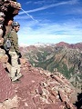
The exposure off the left of the ridge was enormous. I spent 37 minutes on the summit. No clouds, no wind, warm temps and incredible views in all directions. I could see Assiniboine, Bourgeau, Sulphur, Temple, all the ranges deep in the park, Cascade, Banff and Canmore. I spent a long time looking everywhere through the binoculars. Really spectacular to be 6000' above the valley. Eventually it was time to head down. It took 80 minutes to bomb 3000' back down to the gully. The traverse was quick. The upper slope was a perfect descent of scree surfing and plunge-stepping. The rock was deep enough I didn't slip at all. More like controlled falling than anything. I passed many people still on their way up. I slowed down on the slabs. More careful footing was needed because of the loose gravel on the bedrock. Then it was the final quad-pounding drop through the trees on the trail. It went fast but descending something this steep is almost as hard as going up. The final chunk of descent went quickly. Didn't see any bears. Banff was a zoo when I got back to the car. People circling the lot for spots, hordes taking selfies in front of the river, masses of tourists ambling downtown. 
This mountain was steeper than anything I've hiked in Colorado, and the rock on the upper slope was pretty miserable. My only 'loose rock' 14ers so far have been Castle and Conundrum, and I did those in a few inches of snow that helped to hold things together. The rock on Rundle wasn't really dangerous, just loose and annoying. The slabs in the middle of the slope could be treacherous with water or ice, so a dry weather forecast is essential. I hiked Mt. Rundle on a Thursday. The next day I did a huge mountain run at Lake Louise, then spent 2 days in Canmore training at the cross-country ski center. To keep the focus of this report on hiking, I won't go into detail about these outings. If anyone is interested or wants to see photos, the activities are public on my Strava profile and you can PM me. My next hike was Mt. Bourgeau. This is a large mountain accessible directly off the Trans-Canada highway. There are many existing trip reports and trail descriptions- a search for "harvey pass", "bourgeau lake" or "mt. bourgeau" will give lots of good results. Unfortunately for me, I did the entire hike in the rain and mist. I suppose every trip has to have a bad weather day, and this was it. The scenery the first 2 hours was nonexistent. Dense fog, light rain, no people and wet trees. That was it. I wore my rain pants the whole day- first time I've used them- and they were great. Good to know the gear works. The sky opened up a bit as I reached Bourgeau Lake. I could see the whole amphitheater and part of the climb up to Harvey Pass. A duck/tern something was on the lake. The rain continued. I knocked out the hill to the small lake above the basin. I stopped here to put on my gloves, hat and another jacket. Had a brief conversation with a woman on the way down. A quick jaunt around another 2 lakes brought me to Harvey Pass. No views at all. The summit bulk of Bourgeau was lost in the mist above. 


It took 1:10 to go 1500' up from the pass to the summit. I could only see maybe 200' above so it was impossible to gauge the remaining climb. Another tier of rock always appeared out of the fog. Occasionally I could see down some cliffs to the left. At one point I thought the altimeter was too low. Nope. Just took a long time to get to the top. Eventually I reached the summit. I sat on a rock next to a cornice on the east side of the summit. All I could see was the small radio antenna building. 
I spent only 10 minutes on top- just enough to rest, eat, drink and get cold. It rained harder as I started down. I made it to the Bourgeau Lake headwall in 1 hour. Passed 2 groups of 2 at got progressively more drenched as I descended. Took a break to eat and take the wet insoles out of my shoes. I stopped below Bourgeau Lake to watch/listen to a rock slide on the east side of the amphitheater. Looked like part of a cliff got washed out. A huge pile of dirt and gravel poured down a chute as larger rocks bounced down the slope. The sound was enormous- it echoed off the walls and made the slide sound much bigger than it actually was. I marched the rest of the way to the car in one shot. The rain finally quit the last hour and the fog lifted a bit. Everything was absolutely soaked as I de-geared at the car. 2 days after Mt. Bourgeau I did the biggest hike of the trip up Mt. Temple. This is the highest mountain in the Lake Louise/Moraine Lake area, towering 5500' directly above Moraine Lake. Viewed from the Trans-Canada highway, the mountain is a true alpine setting- steep rock faces, enormous cliffs and a large glacier capping the top 1000 feet. However, there is a difficult but non-technical scramble route on the south side of the mountain. The link below, again provided by Parks Canada, gives a good description of the route and the typical conditions of the mountain. I'll add a few more details about Temple that weren't obvious to me at first. The Moraine Lake parking lot fills up VERY early- I arrived at 5 AM and the lot was 2/3 full. It's about the same size as the Mt. Evans parking lot. Once the lot is full, the road to Moraine Lake closes at Lake Louise village, 11 KM away. You will have to park in the village or down at the park-and-ride on the Trans-Canada highway and take a shuttle to Moraine Lake. There are limited spots and the shuttles operate at times that might not be conducive for an alpine start on Temple. Get there early- the 3 AM wake-up is worth it. The link below is what I used to figure out the shuttles for Moraine Lake and Lake Louise. Second, Moraine Lake is in grizzly bear country. While there are only ~60 grizzlies in Banff National Park, there are more black bears and bear safety is hammered into every visitor by Parks Canada. In the past, the trails above Moraine Lake (to Wenkchemna Pass and Sentinel Pass) had a mandatory group size restriction- only groups of 4 or more were permitted to head out into the forest. It seems that restriction has been relaxed in recent years, since the group size was only 'recommended' and not 'required' by Parks Canada. The link below gives all bear/wildlife warnings, restrictions and closures as mandated by Parks Canada. I talked to several park wardens to be sure that I could go solo and not get kicked out of the park or fined. From the reports I read, Mt. Temple is a harder, taller version of Longs Peak. It's 5500' in 5.5 miles to the summit, and the majority of that is on very steep scree. There are a few cliff bands to negotiate that require class 3/4 climbing moves and the very top of the summit ridge runs to the glacier. I took a climbing helmet, microspikes, ice axe and gaiters and made good use of all of these. Be sure to bring bear spray too. Really disappointing to not get this one. I got up at 3:15 and left at 3:45. Deserted highway the whole way. More vehicles appeared on the road as I got to the Lake Louise village. The Moraine Lake lot was about 2/3 full when I arrived. It was quite dark so I slept for 40 minutes while activity raged around me. I geared up and set out as soon as it was light enough to see without a headlamp. I went from the parking lot to Sentinel Pass in 92 minutes. The pack felt heavy but I moved quickly and my legs felt great. I saw only a few people so I talked to myself and banged my ice axe on some rocks to ward off the bears. The switchbacks were moderately steep and the trail was wide, groomed dirt. The sun rose as I went through the basin below Sentinel Pass. 

Clouds blew over the top of Deltaform and the top of Temple was obscured. The slope looked incredibly steep. I passed several people on the headwall to the pass. I took a break on top to take photos and add some layers. I wore ski socks, long underwear and a pair of ski tights on my legs and a longsleeve ski shirt on top. At the pass I put on my lightweight ski jacket, medium-weight ski gloves and climbing helmet. I also put the bear spray in my pack. The first 700 feet up the dark scree went quickly. It wasn't nearly as steep as it looked from afar and a path was mostly discernible. The wind stayed calm and my legs felt great. I blazed past a solo guy and reached the first cliff band only 30 minutes after Sentinel Pass. The climb through this was very simple and more steep rock/scree brought me to the second cliff band. Here I caught a group of 3 middle-age guys and a group of 4 young guys. 
The 3 went up the crux in a deep gully with snow while the 4 went up the marked route. I followed them. Not much exposure but the rock was steep and a few moves were tricky. I passed the 4 and quickly wound up and over the third cliff band. I stopped for a break at 10,500 feet. The views below me were incredible. Dense clouds covered Lefroy and Hungabee to the right above Paradise Valley. Most of the Valley of 10 Peaks was visible. Clouds were blowing around above me. 

I put on my gaiters, spikes, facemask, ski hat and windbreaker. As I resumed snow and ice started to stick to the rocks. The footing was good in the gravel & scree. I bashed out another 500 feet in 20 minutes. The snow was falling steadily but I had complete confidence in my gear, speed and safety. I passed a group of 2 people from New Jersey and talked to them for a minute. I continued upward and 2 minutes later a strong gust of wind hit me from behind. 

I heard a strange sound- maybe the wind whipping the hood of the windbreaker, or the hose of my Camel rubbing on the pack straps. I paused, then heard it again. It was high-pitched and had a 'dense' sound. This time I could tell it was coming from the tip of my ice axe and the spikes. Static electricity. Fuck. I immediately dropped my axe and got in the lightning crouch. I waited for 2 minutes as the New Jersey group caught up to me. They got buzzed too. I thought about continuing. I was only 15 minutes from the top. But, I couldn't see anything and the snow was not about to quit. And the higher I went the morning lightning-exposed I would be. I realized I needed to head down. Really frustrating and disappointing but I couldn't beat the weather. The New Jersey group decided to continue up to tag the top. Neither of them had spikes or an axe. I ran down the upper slopes. The groups of 4 and 3 from the second cliff band merged and I stopped to tell them what happened. They were all just about ready to bail too. I moved quickly down the third cliff band. The snow continued down to the second cliff band and all the rock was wet. I went down the snow gully rather than downclimb the tricky wet rock at the crux. I made a bit of a mess in the gully- lots of junk sliding down- but it wasn't exposed at all and the snow held the axe firmly. I slowed down at the first cliff band. I could see the sun in and out of the clouds. 

I went through the cliffs and down most of the scree slope before stopping at a small flat spot. I took pictures, looked through the binoculars and stewed about turning around. 9 more minutes and I was at Sentinel Pass. I stopped again to take of the winter layers & climbing gear, eat and re-arm with the bear spray. The remaining descent was slow and easy. I just strolled along gazing up at the Valley of 10 Peaks. Many people were on the trail, most not carrying any bear spray. 

The weather stayed cool down to the lake. I went up the rock pile with the tourists and sat on a perch overlooking Moraine Lake. I sat here for 17 minutes, taking photos, looking through the binoculars and looking at the lake. Quite a spectacular place. Hard to feel completely satisfied with the day despite nailing the gear & clothing and moving so quickly up the hill. Some day I'll be back to make it all the way to the summit. 


Overall the trip was an enormous success- I did 52 hours of mountain running, rollerskiing and hiking, didn't get eaten by a bear and felt comfortable in world-class mountain terrain. I will definitely return to make it to the top of Mt. Temple and hopefully go farther north to explore Yoho and Jasper National Parks. Thanks for reading- again please PM me if you want to know more about my experiences in Glacier and Banff. Thumbnails for uploaded photos (click to open slideshow): 


 Mt. Perren, Mt. Allen, Mt. Tuzo and a cloud-covered Deltaform Mountain")


|
| Comments or Questions | ||||||
|---|---|---|---|---|---|---|
|
Caution: The information contained in this report may not be accurate and should not be the only resource used in preparation for your climb. Failure to have the necessary experience, physical conditioning, supplies or equipment can result in injury or death. 14ers.com and the author(s) of this report provide no warranties, either express or implied, that the information provided is accurate or reliable. By using the information provided, you agree to indemnify and hold harmless 14ers.com and the report author(s) with respect to any claims and demands against them, including any attorney fees and expenses. Please read the 14ers.com Safety and Disclaimer pages for more information.