| Peak(s): |
Huron Peak - 14,006 feet |
| Date Posted: | 06/08/2020 |
| Date Climbed: | 06/07/2020 |
| Author: | Verticality |
| Peak(s): |
Huron Peak - 14,006 feet |
| Date Posted: | 06/08/2020 |
| Date Climbed: | 06/07/2020 |
| Author: | Verticality |
| Windy Huron Tour |
|---|
|
Hike Details:
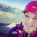
https://www.strava.com/activities/3580898950 Huron Peak via Lulu Gulch with the switchbacks up to Middle Mountain.  We parked at the lower trailhead and spent the night camping in the main clearing. We started our hike with the sun out and rising over the Sawatch range. The weather forecast was calling for powerful winds 20-30mph with 50mph gusts.  As we progressed up the 4wd road we encountered one long flooded section, likely seasonal runoff. It is currently spilling over the trail and into Clear Creek.  We hiked the first mile up to the intersection for Lulu Gulch basin access, which is slightly easy to miss if you aren't looking for it. We took this left fork as it pushed upwards higher than the service road.  The dirt road to Lulu Gulch was much rockier than the initial 4wd road. In spite of that a lifted 4wd vehicle with low gearing could definitely make it up a majority of it. A snowfield blocks the way further up. As we continued hiking a fallen pine marks the exact spot of 11,000 feet.  We continued to push towards the basin by following this rocky but vibrant road through the forest.  Further up we reached a private property sign indicating we were well off-route. Turns out we missed the major turnoff up to Lulu Gulch basin. Instead we reached this dead-end to an old mining area marked out by a solitary aspen grove.  We retraced our steps about 5 minutes back and found the major turnoff, covered in solid morning snow.  We proceeded up the low-angle snowfield, avoiding some of it on the left side where there is some dirt. This quickly led us up into Lulu Gulch basin where the views opened up.  As we hiked through the remaining dirt road in this basin we encountered a short flooded section of trail. The sunbeams poked over Middle Mountain and gave us a warm morning glow.  Immediately past this stretch the road goes through the last patch of forest before reaching treeline. We quickly hiked through the woods and pushed up to the slopes underneath Middle Mountain.  As the main dirt road ends we reached a junction. The path forks off in two directions. We decided to go left and follow the switchbacks up the face to the ridge. An alternate (more direct) route exists going up the tundra and right into the upper basin / slopes under Browns Peak.  The rocks are slightly less forgiving here but the trail is wide enough to keep it low class 2 at most. In some sections the switchbacks narrow to just a few inches wide, giving a slightly uncomfortable feeling over hundreds of feet of steep talus. Most of the path is wide enough for a leisure walk up the face.  Note the only distinguishing difference in this next picture is the patchy tundra poking through the rocks, as well as being slightly higher up the mountain.  Near the top the switchbacks widen and the angle eases. We approached the upper slopes knowing the fierce winds would be waiting for us.  We quickly reached the upper slopes and took a moment to rest and have a snack. We could see the trail in front of us as it winds around and underneath Middle Mountain.  We started to follow the main trail as it led us along the ridge and slightly blocked the wind.  The peaceful landscape on this ridge is only punctuated by the small talus chunks that litter the slopes right underneath Middle Mountain. A quick pace can be sustained on this initial walk over the upper slopes.  Eventually the path disappeared, leaving us confused and staring ahead at another couple thousand feet of steep tundra and large, loose rocks. It may have been smarter here to ascend up to the top of the slopes, but instead we continued at this same elevation. We remained about at the midpoint of the slopes as we traversed.  We eventually reached the end of this slop and hit the saddle before Browns Peak. We had an outstanding view of the backside of Huron Peak.  Looking back here, Gus was finishing up the traverse of the slopes and on to the saddle.  This was our view looking ahead on the slopes going up to Browns Peak. Having not studied the route much ahead of time, we were surprised to be going directly over this large mountain as well.  I snagged a quick picture looking over into this isolated basin behind me.  Going up the steep slopes to Browns Peak was uneventful. The views are great in all directions and the slope is consistent. Snow can mostly be avoided except for this one final 20-foot stretch near the top.  When we reached the top of Browns Peak, we again collected ourselves and enjoyed the view of the remaining hike. The north ridge route is impressive and fun, although never becomes anything more than Class 2.  We dropped down off the top of Browns Peak and started to move over and on to the north ridge. Staying closer to the ridge direct makes it easier to avoid steep talus. The beginning of the ridge starts off wide with ample space to move.  While sticking to the ridge, the views up to Huron Peak were still there.  We kept pushing over the ridge and enjoying views on all sides.  Without too much distress we joined up with the standard route. The final ascent to the summit was definitely steep, but easy-going and still with great views all around.  At the summit I celebrated reaching this spot for the first time. A year ago I tried Huron Peak via the southwest slopes (not a good idea) and did not make it to the top. This was a moment worth remembering!  Gus eloquently helped frame the Apostle Peaks behind us.  The views up here are really incredible. This is definitely a classic 14er and easy access for everybody.  We snapped a few more pictures of the surrounding peaks while trying to hide from the ballistic winds all around us. 50mph gusts were hitting us with undue frequency.  We left the summit and quickly started dropping elevation. It took about 10 minutes to reach the saddle again. From here we followed the standard route down the northwest slopes.  As the elevation dropped the terrain changed into slushy tundra, if there is even such a thing. Small sections of trail were flooded out but nothing disruptive. The trail was much easier than everything up to this point.  As we approached the main basin we encountered the main snowfields everyone is talking about in peak condition reports. Multiple lines can be seen cutting across the basin, none particularly better than the others.  Once we arrived at the snowfields, we bit the bullet and pushed right across. We postholed badly (as expected) sinking down into full puddles underneath the snow. We were grateful to only be doing this on the way down.  We continued down the northwest slopes as the terrain leveled out and became more dry. The first awesome views of Granite Mountain emerged in front of us.  As we descended the welcoming sight of treeline was very much appreciated.  The runoff from Huron could be seen in all its glory feeding the Clear Creek and ultimately the Arkansas River valley.  As we got lower on the slopes a more lush view of Granite Mountain continued to rise in front of us.  Near the bottom we encountered a small section of flooded trail which can carefully be crossed without issue.  Finally we reached the main trailhead of the standard route for Huron Peak.  We walked back towards our cars, on the easy dirt road with the beautiful environment all around us.  Took a chance to relax by the water and end the day on a good note.  Thumbnails for uploaded photos (click to open slideshow): 


|
| Comments or Questions | ||||||
|---|---|---|---|---|---|---|
|
Caution: The information contained in this report may not be accurate and should not be the only resource used in preparation for your climb. Failure to have the necessary experience, physical conditioning, supplies or equipment can result in injury or death. 14ers.com and the author(s) of this report provide no warranties, either express or implied, that the information provided is accurate or reliable. By using the information provided, you agree to indemnify and hold harmless 14ers.com and the report author(s) with respect to any claims and demands against them, including any attorney fees and expenses. Please read the 14ers.com Safety and Disclaimer pages for more information.