Download Agreement, Release, and Acknowledgement of Risk:
You (the person requesting this file download) fully understand mountain climbing ("Activity") involves risks and dangers of serious bodily injury, including permanent disability, paralysis, and death ("Risks") and you fully accept and assume all such risks and all responsibility for losses, costs, and damages you incur as a result of your participation in this Activity.
You acknowledge that information in the file you have chosen to download may not be accurate and may contain errors. You agree to assume all risks when using this information and agree to release and discharge 14ers.com, 14ers Inc. and the author(s) of such information (collectively, the "Released Parties").
You hereby discharge the Released Parties from all damages, actions, claims and liabilities of any nature, specifically including, but not limited to, damages, actions, claims and liabilities arising from or related to the negligence of the Released Parties. You further agree to indemnify, hold harmless and defend 14ers.com, 14ers Inc. and each of the other Released Parties from and against any loss, damage, liability and expense, including costs and attorney fees, incurred by 14ers.com, 14ers Inc. or any of the other Released Parties as a result of you using information provided on the 14ers.com or 14ers Inc. websites.
You have read this agreement, fully understand its terms and intend it to be a complete and unconditional release of all liability to the greatest extent allowed by law and agree that if any portion of this agreement is held to be invalid the balance, notwithstanding, shall continue in full force and effect.
By clicking "OK" you agree to these terms. If you DO NOT agree, click "Cancel"...
I’ve been living vicariously through everyone’s trip reports over the past few months, many of them filled with beautiful photos of the mountain landscapes, crisp images of blue skies and snow capped peaks and have been really itching to get out.
I was going to call this report “Escape from New York” but remembered an ‘80s era movie with the same name so didn’t want to risk any intellectual property infringement. Escaping New York City though was what this trip was all about, driven first by the density of coronavirus cases then the violent protests and riots which left blocks of broken windows and looted stores under my apartment and firebombed NYPD vehicles down the street, really making us need a break from all this.
2020 has been a stressful period for a lot of people probably including many people reading this. New York was hit hard and early by the COVID-19 and as such took harsher preventative measures, which together caused a lot of people to flee the city and all non-essential places to close, many of which remain closed today all causing a strain on the economy and increasing stress levels in the city. Several people from my office and in my apartment building perished so clearly things could be worse and we are fortunate to be healthy.
*And importantly, Thank you to all the front line and essential workers out there*
I hadn’t taken a day off since December so was due for a few vacation days and sorely needed some quality time in the mountains. Once rental vehicle places were reopened again, we were able to rent a car and head up to the North Country to the Adirondacks. We planned to hit it hard and climb whatever we could weather and bodies permitting.
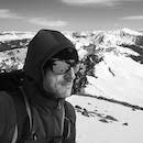
The above shot is a view from the summit of Iroquois Peak and I think captures the “feel” of the mountains up here well.
I was a bit concerned about my fitness not having been inside a gym in four months given the COVID closures (gyms are still closed as of this writing) so I’d be relying on the miles I’ve been putting on my 1990s era stationary bike since March which are probably enough to have ridden to Denver by now.
While their elevations are low compared to Rocky Mountain peaks, Adirondack peaks are rough and unforgiving when you don’t respect them but figured we’d take it slow and see how we feel, and at least we wouldn’t be contending with altitude as well on this one. When viewed from a distance, many of the summits in these parts are rounded giving an impression they’re an easy walk up, which often isn’t the case. Peaks like Mount Marcy, Cascade, Porter are easier walkups but many others are quite a bit more challenging.
Our targets would be within the “High Peaks” area, i.e. the 46ers and some other notable hikes. Some of these climbs would be repeats (Algonquin, Colvin), the rest would be new.
We had a loose Itinerary subject to the weather and our energy. Massive thunderstorms blocked out any ideas we had for two of those days, work interrupted another then after Redfield/Cliff a shorter day was in order, but despite the setbacks we ended up with a decent amount of time in the mountains. Keep in mind that while the mountains seem low in overall height especially given the fact that they are lower than many western mountain cities (!), the local trailhead elevations range from under a 1,000ft to 1,700-1,900ft in elevation resulting in some good gain for any climb.
Itinerary:
Algonquin Peak, 8.6 mi, +3,000ft gain
Algonquin Peak, Boundary Peak, Iroquois Peak 10.8 mi, +4,003ft gain
Mount Redfield, Cliff Mountain, 19.5 mi, +4,750ft gain
Goodnow Firetower, 4 mi, +1,102ft gain
Blake Peak, Mount Colvin, 17+mi, +4,320ft gain
Seward Mountain, 14mi, +3,310ft
Week’s tally: ~74 miles, +20,485ft vertical gain
Iroquois Peak, 10.8 mi, +4,003ft gain (with an additional trip up Algonquin Summit day before, 8.6mi, +3,000ft gain thrown in for fun)
Our first objective was Iroquois Peak (4,840ft). You need to climb up and over Algonquin Peak (5,115ft) first then over Boundary Peak (~4,829ft) in order to reach Iroquois then reverse that to return. I first climbed Algonquin Peak 13 yrs ago so this was like visiting an old friend.
These peaks are reached from the popular ADK Loj Trailhead, which luckily was now open after being closed for a while but wasn’t too crowded. As Montreal is only a two hour drive, French Canadian hikers are frequent visitors here. Given that the northern New York border to Canada was still closed, this contingent of the hiking population was not here, not to mention the normal summer visitor traffic was down so there were plenty of available parking spots at the trailhead, which is rare for a summer day. I don’t usually climb up here in the summer in part due to the crowds (and bugs), but this week’s hiker volume was pretty light relatively speaking compared to normal years. What was missing in hikers was made up for in bugs.
We got started at sunrise. The weather started out cloudy and stayed overcast and chilly in the 30s, chance of precipitation was 15% growing to 20% by afternoon, we felt the risk of being rained out was not huge. This route is a marked route for a change, characterized by steep slabs sprinkled amongst the glacial erratics and root-filled trail so not the best route to be on in the rain, but we gave it a go as it was pretty short as summit objectives go up here.
As most routes up here, there is a nice open trail to start out from the parking lot which passes through the nice forest filled with maple, beech and birch. After a mile and then after breaking off from the main trail towards state high point Mount Marcy (while this is a main route up, there are several ways up Marcy), the route starts to become more heavily strewn with boulders and rocks, which increase in size and complexity as you get higher and an increasing mix of spruce and fir mixed in as you get higher.
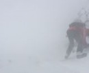
As luck would have it, as we hiked higher and about halfway up the 8.6mi roundtrip route to Algonquin’s summit it started to snow. In the above pic, Nicole clinging to a steep slippery slab (pic taken on the descent).
Most routes in these parts use what I like to call “Class T” for “Tree assist”; these are key to the climbs on many of these slabs! It had been warm enough in prior days so egg-shelled ice was luckily not much of an issue as it would have been a month earlier. The snow stuck to us though and made the ascent a bit taxing as the wind blew it in our faces.
Above treeline in the alpine zone:
Above tree line the wind kicked up and made the snow and sleet become horizontal and generally pretty miserable. The extended forecast called for improving weather and since there was a marked trail to follow, kept on towards the summit. We made it to the top to see if would the weather would improve over that time period then we’d assess whether we go further to Iroquois. However, given the now whiteout conditions, the continued storm and the fact that Iroquois was one of those peaks with a mile+ of unmarked route to reach the top and we couldn’t see the mountain, we made the decision to turn around. This was the second time I’d be turned around by weather on this same summit. It continued to snow and then lower down, rain most of the day.
Fast forward to attempt number two: After the storm cleared, the weather was dry and forecast was looking solid so we went out again. With a sense of deja vu we repeated the climb up Algonquin with partly cloudy skies and a great day, 20 degrees warmer, no precipitation though pretty strong winds, but nonetheless which made for a great climb. We summited about 40min quicker today compared with the prior climb..
On the taller peaks in the more popular areas, the Adirondack Mountain Club sometimes has “Summit Stewards” on the mountain tops which are volunteers which spend time on the summits, educating hikers and climbers about the geology and biology of alpine life and are usually in radio communication with rangers in case of any emergency higher up. It’s a pretty cool program and they usually have good information to share. There was one working today and they were in good spirits despite dealing with 20+ mph winds all day.
Very interestingly on the approach to the summit, I saw this newly planted sign: warning anyone approaching the summit to wear a mask. I thought I could escape this but even up here, the long reach of COVID is evident:
I found this surprising that nearly five miles from the end of nearest dirt road on a summit which is fairly involved to get to that we needed a mask in what were probably 25-30mph winds. We left our masks in the car, so a buff wrapped around our face would have to do and so we walked on top.
Colden's aggressive slides shown below taken from Algonquin's bald summit. Mount Marcy in the distance left center
There are a couple of cairns near and on the summit of Algonquin marking the route, aiding mountaineers navigate in the oft-present whiteouts.
Without further ado, now finally in good conditions we identified Iroquois and the direction of route and marched over there.
The backside of the upper reaches of Algonquin in the Distance From Iroquois
The hike over to Iroquois requires you to drop down roughly 500ft, first to the col between Boundary Peak and then the col between Boundary and Iroquois and then backtrack re-ascending Boundary then Algonquin from the south side, the first time I’d been on this side of the mountain, which was a nice alternative and much easier way to climb up (had one started from this side) than the north side from which we came.
As is typical here, what looks easy from far away actually has some challenges as you get closer in the weeds. The route involves some decent scrambling and some rock sections that deserve attention. Most trickier spots have more than one way up to choose you option and go. I’d imagine many sections would be considered 3rd or 4th class depending on your line. It was great the rock was dry today. One nice thing about climbing on these sections is that the rock is effectively part of the mountain and doesn't pull out and is pretty bomber.
On the way to Iroquois, while there are no markings indicating the trail or peak names, there is one crucial turn you need to make which is there the “trail” reaches a fork where to the left is the way down towards Lake Colden. At this point you need to go right towards the unmarked herdpath which is the direction of Iroquois. Miss this turn and you’ll find yourself a few thousand feet down the other side of the mountain so pay attention.
You then continue the descent into a stand of stunted fir for a while which provide a brief reprieve from the wind. Once out of the trees, all along the hike back to and from Iroquois, you have great views of the surrounding mountains, forest and lakes below. The cloud patterns today made the view even better.
In the panoramic pic above, the higher reaches of Algonquin is the peak to the left, Mount Colden and its impressive “slides” is to the right and Mount Marcy off in the distance to the center right above Colden.
On top Of Iroquois we sat in silence enjoying the peace and vantage point from which to savor the surrounding wilderness. The air was as fresh as it comes.
It was SO NICE to be up here in what felt like a million miles away from any virus. After relaxing on the summit taking it all in, we packed up and hiked back over what would be my fourth summit of Algonquin and went back down. Very few people were on this route today.
Mount Redfield, Cliff Mountain, 19.5 mi, +4,750ft gain
Mount Redfield (4,606ft) and Cliff Mountain (3,960ft) together make for a long ~20 mile day with a decent elevation gain of over 4,700ft over unmarked, tough terrain once you leave the approach trail.
While there is another route starting from the southwest side of these two peaks, the routes we chose for both start at the same Loj trailhead as Algonquin and Iroqius. Rather than turning to hiker’s right this time (as you do climbing Algonquin/Iroquois), we’d turn towards Marcy Dam, then stitch together a few routes to get to the start of the climbing. One thing to note is there are no formal (or informal) signs for Redfield or Cliff pointing the way at the trailhead or any of the trail junctions. Only at a point roughly 8 miles in will you see a small cairn where you’d know to turn off, more on that later.
Many of the longer and more difficult ascents up here have you arriving at treed-over summits with little or no fanfare and no view, such is the case with Redfield and Cliff. These are peaks where while on most of the “route” you’re crossing your fingers that you are in fact climbing the right mountain. Luckily, while summit registers have been removed (as a nod to LNT) there are signs now on the summits, or actually nailed to trees on the summits affirming that you did indeed climb the mountain you set out to climb. I’ve ran into more than one climber that was on the wrong peak or wrong route.
Earlier on in the route you’ll pass a sign for the first Leanto (if you don’t see this you’re on the wrong track and you’ll need to backtrack to find the correct path).
Not too many folks were using these this week
The “Leanto” is a popular backcountry shelter used around these parts for camping. There are two-three of these you’ll pass along the way. They’re not located on the trails but about 200ft off trails reached by a short spur/path.
To get to these two peaks you need to closely follow a map and string together a few different trails and pay attention to turn offs to make sure you get yourself in the right place before you go off on the remaining unmarked route to the top. We opted to take the route towards Arnold Lake and then head southwest from there towards Feldspar.
Root ascent
One thing to note with these two peaks at least coming from this direction was the elevation you lose on the way that needs to be made back up on the return, this was a bit demoralizing.
After Lake Arnold the trail starts to become rockier and then devolves into a marshy section where you’ll need to balance across logs, boards and planks in the water to cross. “Walking the planks” is tricky (especially when windy or icy) and many of them are semi free floating, loose or rotten and you need to be careful as the water here could be several feet deep in spots, then covered in quicksand like mud at the bottom, not a place you want to fall in. If you run into a moose in these parts, you better hope it loses interest in you else you won’t be a good spot.
Reminds of the game "Pick up Sticks"
Almost across
While it’s a bit precarious to cross, it’s a beautiful place and one of the flatter areas around surrounded by mountains. Interestingly we saw several frogs here today.
The route starts to get a bit more complicated from here though still sticks a rockier trail of sorts and not yet the steep slabs you’ll need to climb later.
Soon you’ll reach a junction, that is marked by a single cairn which then branches off into two faint “trails” or herd paths, one leading hikers left to Redfield and one leading hikers right to Cliff.
If you look closely you’ll see at the arrows carved into the dead tree trunk, you see a “C” to the left and an “R” to the Right, indicating the directions to Cliff and Redfield.
This is the crucial junction you need to find. Miss these signs and you’ll be on your own finding the peaks on a massive bushwhacking adventure.
After this point the route becomes harder and less defined
Hard to capture in a photo, the route up Redfield starts off fairly well trammeled then sort of disappears across a running streams and water covered lower angle slabs.
These soon turn to steeper slabs mixed in with boulders where the fun continues. At least there were no false summits here, its all UP.
The route parallels a creek for about a few hundred yards then veers off up into the woods and moves alongside another branch of the boulder covered creek and then continues right through the middle of the creek for another few hundred feet. Chances are if you didn’t get wet with the planks, you’ll probably get wet here.
Once you exit the creek, you’ll turn into and stay in the forest the rest of the way, which will take roughly 30-45min to the top from here and you’ll actually find some well appreciated trail segments in here. The route from here consists of a meandering herdpath over the typical roots, ravines and boulders.
There are many of these 10-15ft rock sections that need to be surmounted. After a steady push “up” and a solid 6+ hours of effort, the summit suddenly and unspectacularly appears and is marked with a simple wooden sign nailed to a tree with little view surrounded by trees.
Without resting to eat we turned around and headed down not wanting to spend too much time since we had Cliff Mountain left and from what we understood was filled with tougher terrain higher up than Redfield. It took about 40min to get back to the junction and then the fun started. At the junction we then made a turn hikers right towards Cliff.
The beginning of the route up Cliff was a muddy mess. There was a solid quarter mile of mud to contend with loosely covered by weathered logs that seem to have been put there in the 1800s most of which rolled upon being stepped on.
The “route” then consisted of abruptly steeper terrain, slippery slopes, slabs, boulders and more downed trees than up Redfield.
There were some legitimate Class 4 moves on some of the rock to get up to Cliff which caused a few folks pause we met on the way and people were trying to do a direct “through the forest” approach to avoid them but the brush was too thick to allow that. The best way is really just up the rock. The exposure on some of the rock here was more than anything on Redfield or many other 46’ers
After passing and surmounting twice sections that I figured were the crux of the route, yet another significant wall appeared we’d need to get up and over. Right around this spot we finally ran into a few people struggling to move past this and this section seemed to act as a bottleneck on this mountain.
Getting up this took some creativity. At least when we got to this last tough section, there was a nice view of the surrounding peaks, then back into the woods again.
Moving through the woods, we felt we were finally on top, we looked around for the summit sign (again this one has no marked trail so we were trying to confirm we were in fact (i) on the top and (ii) on top of the correct peak and kept walking around, only to find another path indicating this was a false summit. Ugh. We walked and dropped down maybe 200 hard earned vertical feet, then started ascending again and finally made the actual summit. Again without much fanfare, the summit appears out of nowhere and after all that effort, some 7+hrs after we started there was no view.
This is what you are greeted with on each summit. In reality, these are coveted signs to reach.
Cliff Mountain was aptly named. Descending this peak was a bit tricky particularly doing down those 4-5 crux type sections and took about the same time as climbing up. It made me think of those tattered ropes that accumulates on Little Bear and some of these spots would made good rappel stations, with a clean rope.
Making it back to the junction was welcome relief as we knew the hard part was behind us and was just a flattish hike back and with the exception of the floating boards, an uneventful walk out, albeit a 7+ mile one. Not sure if we had more bug bites or bruises and scrapes from the day’s adventure, but by the time we got back to the car we were pretty worn out. We saw maybe four people the whole day from sunrise past sunset. Great social distancing.
Goodnow Firetower, 4mi, +1,100ft gain
It started raining that night and the next day we awoke to torrential rains and thunderstorms which lasted all morning. When it showed signs of letting up, I still wanted to get out figured I’d do something shorter. Nicole stayed back so I drove to a trailhead about 90min south and planned a firetower climb. I needed an easier day after being beat up by Redfield and Cliff so opted for Goodnow Mountain which is about 4mi roundtrip and +1,100ft gain.
In the Adirondacks there are roughly 30 mountains with firetowers placed on top, all of which have good views from their respective summits and make great summit hikes some more challenging than others. Due to COVID, all firetowers upstate New York were closed to hikers (meaning the ascent to the cage of the firetower itself) but the hikes to the summit were open and allowable.
Skies were clearing on the drive down to the trailhead which was in a remote farming town to the southwest and it was a beautiful day with some clouds. I was the only car in the parking lot.
Of course as soon I started the hike up the sky opened up and it poured rain the entire hike up until the summit. Since I was soaking wet anyway and it wasn't cold I took a break on top for a snack and it cleared for a few minutes enough to snap a photo or two then rained for the remainder of the hike down but it was a nice little climb to the top. Nobody was on the peak. I understand the top of the tower was struck by lightning recently - You can see the distorted roof if you look closely at the top of the tower.
It continued to rain and thunderstorm for two solid days. Given the obvious risk of lightning especially up high coupled with the wet slabs and rock and inevitable mud pools we’d encounter on any climb, we opted to not hike anything for these two days and frustratingly decided to stand down from any peaks.
Mount Colvin and Blake Peak, 17mi, +4,300ft gain
Years ago I climbed Mount Colvin (4,057ft) but never made it further to Blake Peak (3,960ft), so I had some unfinished business to take care of. This is another mountain where you need to climb up and over another (in this case Mount Colvin) to reach Blake at least from this side of the mountain. There is another route from the west though that trailhead is 90+min away and I think this route is more scenic.
We started at the popular St. Huberts Trailhead, which was packed before sunrise so we had to park a mile away. Taking advantage of the super long summer day at higher latitude bringing more daylight, we started a bit later today. After walking a mile, +/- more, the route passes through the nice historical Adirondack Mountain Reserve Gate. Similar to the Loj trailhead, from this trailhead there are literally dozens of mountains accessible through a variety of trails along the way.
After 3-4+ miles of required walking on a dirt road (the amount varies depending on which trail you take to get into the woods as you have a few options), once you break off, you start to ascend slowly through the woods. This route doesn’t gain much until closer to the end and then becomes quite steep in sections. Most of the first five miles parallels Gill Brook and other tributaries which makes for a nice walk in.
Lots of waterfalls on this route, especially after a couple days of rain
The terrain soon becomes the classic slabs and boulders and passes through many cascading waterfalls. Be warned if you stop to admire the view too long bugs will start to devour you.
Steep moss covered rock defines this route
Along the way we saw some nice life along the stream.Saw a newt also but didn't get a photo of it though many frogs and toads in the underbrush.
There were definitely some rock challenges where we needed to stop for a moment and think about the best ways to climb up, most of these involved the use of trees and roots.
The last time (and only time) I had done this route was in early Spring snow which covers most of the boulders. While it entails steep iced-over flows, cascades and rocks, it does smooth out most of the route since the snow and ice fills in the crevices between boulders so seeing this terrain dry was like climbing a new mountain today.
I was surprised at the rough terrain once you start the meaningful ascent up in the woods after the waterfalls. There is not much of a view from the summit of Colvin but it’s a steep undertaking to get to the top. You’ll need to go over 3-4 steep rock sections before seeing the summit block shrouded in part by trees, which is maybe 40 feet tall with a couple of options to get up.
In the below left photo you can see a person standing on the summit block of Colvin to give you some scale. The summit marker is the round metal plate in the pic. Bottom right pic is the summit of Blake Peak. hidden in the trees.
A handful of fellow 46'ers are viewable from Colvin's summit
Descending from Colvin towards Blake was pretty brutal in the wet mud and slabs and near vertical drop-offs. You'll soon reach a section of maybe 200ft sloping down which is solid mud with few spots of terra firma on which to find purchase, so this will take some time to move through.
This section rivals Cliff Mountain for difficulty and is just plain treacherous terrain.
In a clearing we briefly get a glimpse of our goal, Blake Peak as we descended into the abyss of tightly packed fir and spruce along steep slippery slopes
From afar, it looks like such a nice easy peak to ascend; it’s quite deceiving for underneath that gentle looking profile and seemingly pleasant blanket of coniferous forest lies heavily eroded ravines, twisted roots and huge slabs of near vertical rock surrounded by cabin-sized boulders covered in wet moss and slick lichen.
Blake Peak is situated 1.4 miles from the summit of Colvin and it makes for a tough down and up, and back down and back up to Colvin to exit back out. It’s a 500ft drop into the Colvin-Blake col (which needs to be reclimbed on the way back), but given the difficulty of the terrain feels like more.
There are some ladders strategically placed in the taller vertical sections to help. There are some rungs loose on these ladders so be careful. Bugs abound in the valley here and continue in the col and the climb up to Blake.
The terrain between Colvin and Blake is unrelentingly steep.
This slide like area had been eroded away and left with bare rock from one of the recent winter/spring storms
More "UP"....a few options exist here, we went basically straight up the middle
Slabs...I think these types of sections are actually easier to climb with crampons when iced over
Over the river and through the woods...parts of the route travel along or through the creek
Good place to soak the feet
After several back to back steep slab climbs, we finally made it to the summit of Blake which as the earlier picture shows is treed over with no view again.
We took a nice breather on top of Blake to hydrate and then headed back down into the steep gulleys and rockslabs in what seemed like a training ground for American Ninja Warrior tryouts.
We did see several quieter pools with nice trout populations, making a mental note for next time maybe bring my rod with me…Any water around here was ice cold and incredibly refreshing to put your bare feet in.
Seward Mountain, 14mi, +3,300ft
We knew this one wasn’t going to be easy but at least it was a bit shorter than the other two longer days we had this week.
Seward Mountain (4,361ft) is part of the Seward Range, located in the central-western part of the Adirondacks and is one of the more remote peaks in one of the more remote ranges up here and is also reached by an unmarked route.
After a 45min drive, we got to the Seward Chain trailhead. The start out from the parking lot is easy on a nice flat path which lasts a while with some ups and downs.
You have roughly a 4.7 mile one way approach hike to get to the turn off which marks the start of the remainder of the route up to Seward which is not marked. You’ll leave the trailhead, and be heading east in the direction of Blueberry Leanto (4.5mi away). First you’ll come across the leanto popular with campers near a truck trail, then about a 1/4mile past this you’ll see a cairn.
Anyone camping is encouraged to use the Leanto, there are three-four of them spaced over about a mile.
I found this scene funny so I took a pic- Not my tent but guess people can’t read.
In the pic below you’ll find a cairn after the wood bridge after which you’ll turn right (south) and continue up the mountain. This is a crucial (and only) marker for the direction up to Seward so don’t miss it.
From here it’s a little over two miles to the summit and about 2,400ft vertical gain remaining, but after the initial flat section, its slow going. You’ll pass a few pools and scenic rock dammed streams and a lot of mud especially if had recently rained. There is a lot of water in this area, seemingly draining out of every seep in the mountain.
The route becomes a little confusing here and there, especially as it meanders through the woods and is harder to identify when covered with leaves or snow. The route cross the creek a few times but mostly follows the running water up the northern flank of the mountain. There is plenty of water on this route, literally almost to the summit, so no need to carry more than a liter at any time assuming you have some sort of filtration.
There is a nice flat spot or two before the terrain gets steep and unruly. Nice spot to take a break, though the bugs like this scenic spot too.
The route then becomes progressively steeper and follows large boulders over the running creek-this shot is characteristic of the terrain for at least a mile worth of trail.
It’s a tiring and slow ascent up through the broken boulder field and up through muddy ravines.
After a couple of hours of navigating a route up, finally nearing the end of the stream/cascade that you’ve been following you’ll come to the Seward summit block, which is about two city blocks long.
When you reach it, turn and immediately walk due east (hikers left) on a refreshingly flat section of exposed soil and you’ll eventually come to what appears to be slightly easier access to the top. You’ll still have to do some vertical climbing, but it’s easier to the left as you won’t top out in dense brush like you would if you try climbing anywhere near the right side or where you topped out to meet the summit block massif.
The summit block. Follow the wall east.
A shot of the last slab before the summit block, the summit block and then the summit! Again, sadly there was no view from the summit proper, but there were some nice views at some spots before topping out.
The wind had died once we got to the top, which meant the bugs came out in force. A bug net would have been fantastic to have but alas, neither of us had one. So we just turned around and head back down.
The trip back out took about the same time as the climb up given the complicated terrain coming off the higher reaches of Seward. There is also some elevation to make back up on the approach hike once you get back to more stable ground for that last 4.7 miles back to the trailhead.
This was a tiring trip, but totally worth it and was such a nice break from a stress filled civilization where we spent the last four months. There truly is freedom in the hills...
The one thing I regret doing was wearing shoes with slightly worn soles which didn’t grip well on all the rock, especially when wet. Approach shoes work well on some of the rocks.
If anyone is around the area, there are some great hikes up here and crowds are expectedly light. Just bring rain gear and an (operational) water filter- one of my filters froze up and didn’t work.
And enjoy forever wild in the Adirondacks
Thumbnails for uploaded photos (click to open slideshow):
I often wonder how many people have never reached the true summit of Cliff and agree that it has one of the trickier scrambles of the 46ers. It also has some of the worst mud. I see you took the same path I did from the Loj past Lake Arnold and Feldspar. The planks weren't linked and I sank about two feet in crossing that trail so I think it's always best to go around Lake Colden and follow the Opalescent up.
Blake is another of the 46ers that I have no desire to repeat. I did that in a fun day with Dial, Nippletop, Colvin, and Blake. The descent off Nippletop via Elk Pass is one of the steeper trails I've been on and was a little icy.
I've always wanted to continue over Iroquois to Marshall as there are a few cliffs that pose an interesting down-climb/rappel.
Caution: The information contained in this report may not be accurate and should not be the only resource used in preparation for your climb. Failure to have the necessary experience, physical conditioning, supplies or equipment can result in injury or death. 14ers.com and the author(s) of this report provide no warranties, either express or implied, that the information provided is accurate or reliable. By using the information provided, you agree to indemnify and hold harmless 14ers.com and the report author(s) with respect to any claims and demands against them, including any attorney fees and expenses. Please read the 14ers.com Safety and Disclaimer pages for more information.
Please respect private property: 14ers.com supports the rights of private landowners to determine how and by whom their land will be used. In Colorado, it is your responsibility to determine if land is private and to obtain the appropriate permission before entering the property.