Download Agreement, Release, and Acknowledgement of Risk:
You (the person requesting this file download) fully understand mountain climbing ("Activity") involves risks and dangers of serious bodily injury, including permanent disability, paralysis, and death ("Risks") and you fully accept and assume all such risks and all responsibility for losses, costs, and damages you incur as a result of your participation in this Activity.
You acknowledge that information in the file you have chosen to download may not be accurate and may contain errors. You agree to assume all risks when using this information and agree to release and discharge 14ers.com, 14ers Inc. and the author(s) of such information (collectively, the "Released Parties").
You hereby discharge the Released Parties from all damages, actions, claims and liabilities of any nature, specifically including, but not limited to, damages, actions, claims and liabilities arising from or related to the negligence of the Released Parties. You further agree to indemnify, hold harmless and defend 14ers.com, 14ers Inc. and each of the other Released Parties from and against any loss, damage, liability and expense, including costs and attorney fees, incurred by 14ers.com, 14ers Inc. or any of the other Released Parties as a result of you using information provided on the 14ers.com or 14ers Inc. websites.
You have read this agreement, fully understand its terms and intend it to be a complete and unconditional release of all liability to the greatest extent allowed by law and agree that if any portion of this agreement is held to be invalid the balance, notwithstanding, shall continue in full force and effect.
By clicking "OK" you agree to these terms. If you DO NOT agree, click "Cancel"...
Thursday, Sept. 3, 2020. Randy and I attempted Mt. Powell on Aug. 29, 2020, despite the lousy weather forecast (40% chance of morning showers and 80% chance of afternoon thunderstorms). We thought we could stay ahead of the rain with an early start, but the rain began about 6:30 AM and never let up. We were about 200' below Kneeknocker Pass when we decided to bail out. After all, Randy's bicentennial finisher should be fun, not a miserable slog in the cold and rain.
The Labor Day weekend weather forecast (no chance of rain) was too good to pass up, so we made the long drive to Vail and up Red Sandstone Road toward Piney River Ranch and found a campsite not too far from the trailhead.
Looking north from our campsite located a short distance below Piney River Ranch and the trailhead
Friday, Sept. 4, 2020. We made the short drive to the trailhead and started hiking at 4:40 AM. The moon was quite helpful in lighting the way. Our plan was to reach the intersection with the informal trail to Kneeknocker Pass at first daylight, but it was still dark when we got there. Happily, on Aug. 29 we'd waypointed the intersection for our (and your) convenience:
13S 0383402 and 4399249 (Lat.: 39.737054 and Long:. -106.360700). The elevation is about 9770' at the trail intersection.
There is a cairn on each side of the Kneeknocker Pass turnoff and another cairn on the large rock just past the turnoff. A previous trip report mentioned the turnoff as being near a leaning pine tree, but that tree has since fallen over. (The next four photos were taken on the descent.)
The Kneeknocker Pass turnoff (left) is marked with a cairn on each side of the trail. A third cairn is by the fallen tree
A closer look at the no-longer-leaning pine tree and cairn just past (east of) the intersection with the Kneeknocker Pass trail
Some of the lower sections of the Kneeknocker Pass trail are somewhat faint but are marked with cairns.
Follow that cairn!
Look closely and you'll see two cairns marking the trail
Kneeknocker Pass (right of cemter) from just above timberline
Looking back down the trail from the same location as the previous photo
The trail becomes rather steep as it approaches Kneeknocker Pass but isn't too bad, especially considering it's not a constructed trail. We took a food break at the pass to recharge for the final 1200' climb to the summit.
Looking back (southwest) at Piney Lake (upper center) from Kneeknocker Pass
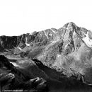
From Kneeknocker Pass, the summit of Mt. Powell is the high point just right of center. The easiest route is up the grassy slope (center)
The east side of Kneeknocker Pass is well-known for holding lots of snow until late in the year. Snow was not an issue today, however. We descended about 150' on the east side of the pass and then contoured north toward an obvious steep grassy slope.
"Peak C" (13,220') from our route between Kneeknocker Pass and Mt. Powell
Looking up at Mt. Powell (right) from the same location as the previous photo
Eventually, the grass ends, and a scramble up the rocky slope takes you to the summit of Mt. Powell
Looking back (south) at Kneeknocker Pass (just left of center) from the same location as the previous photo; you can see why we didn't ascend the ridge
We climbed onto the summit of Mt. Powell together and were glad to be here on a day with great weather. Postponing Randy's bicentennial finisher by six days definitely made for a much more enjoyable experience.
Randy stands triumphantly on Mt. Powell's summit, with "Peak C" (13,220') in the background
Randy's bicentennial finisher celebration wouldn't be complete without our Packers flag
Looking southeast from Mt. Powell's summit
Mt. Powell's summit cairn, with Piney Lake visible to its left
Looking NNW at Eagles Nest (13,420') from Mt. Powell's summit
Looking ENE toward Duck Lake from Mt. Powell's summit
The view northeast from Mt. Powell's summit; Dora Lake is right of center on the plateau
We refueled with Girl Scout cookies (thanks, Laura!) while spending 45 or 50 minutes enjoying the views from the summit. The descent went quickly, and we returned to the trailhead just before 2 PM.
The Piney River trail is a nice one
Once Piney Lake came into view, we knew it wouldn't take long to reach the trailhead
Looking back toward Mt. Powell and Peak C from the same location as the previous photo
We got home in time to have a proper celebration dinner with pizza and root beer. Now Randy gets to decide what future mountain goals he wants to pursue. My favorite comment on Randy's finisher thread was when Mike (Chicago Transplant) said "way to make your dad repeat a bunch of them too."
Thumbnails for uploaded photos (click to open slideshow):
Gotta say I���ve enjoyed reading your reports for many years. Congrats to your entire family. Three Cent finishers and two Bicents in the same climbing posse is something else. Oh, and GO PACKERS.
Bill, Jay, Barnold, Glen, and Jason: Thanks for the kind comments.
Caution: The information contained in this report may not be accurate and should not be the only resource used in preparation for your climb. Failure to have the necessary experience, physical conditioning, supplies or equipment can result in injury or death. 14ers.com and the author(s) of this report provide no warranties, either express or implied, that the information provided is accurate or reliable. By using the information provided, you agree to indemnify and hold harmless 14ers.com and the report author(s) with respect to any claims and demands against them, including any attorney fees and expenses. Please read the 14ers.com Safety and Disclaimer pages for more information.
Please respect private property: 14ers.com supports the rights of private landowners to determine how and by whom their land will be used. In Colorado, it is your responsibility to determine if land is private and to obtain the appropriate permission before entering the property.


 is marked with a cairn on each side of the trail. A third cairn is by the fallen tree")
 the intersection with the Kneeknocker Pass trail")
 from just above timberline")

")
 at Piney Lake (upper center) from Kneeknocker Pass")

 from the same location as the previous photo")

 at Kneeknocker Pass (just left of center) from the same location as the previous photo; you can see why we didn't ascend the ridge")


 from Mt. Powell's summit")