| Peak(s): |
Atlantic Peak - 13,856 feet |
| Date Posted: | 01/08/2021 |
| Modified: | 01/09/2021 |
| Date Climbed: | 12/14/2020 |
| Author: | CaptainSuburbia |
| Peak(s): |
Atlantic Peak - 13,856 feet |
| Date Posted: | 01/08/2021 |
| Modified: | 01/09/2021 |
| Date Climbed: | 12/14/2020 |
| Author: | CaptainSuburbia |
| Almost winter Atlantic |
|---|
|
Atlantic Peak was not on my radar and I'd only heard of it in passing. A buddy of mine suggested it and was familiar with it, so I agreed to give it a go. The Colorado snowpack had been a bit unstable during this week, and his experience on this peak made me more comfortable with the current avy conditions. A couple other friends joined making us a group of 4. Day of Climb: December 14th, 2020 Trailhead: Mayflower Gulch Peak: Atlantic Peak Route: West Ridge Mileage/Elevation Gain: 6.6 miles and 2804 feet of gain. We all met in the Mayflower Gulch 2WD parking lot and started our climb around 4:45 in the morning.The road to the 4WD parking was gated and snow covered. We quickly went the 1.4 miles up this road to just before the Boston Mine ruins in snowshoes. The road was well traveled and boots probably would have been good enough. Here, we passed through another gate and turned left angling down into Mayflower creek where we encountered thick willows and deep snow. We put in a fresh trench, and made our way across the willows heading north into the trees. Before reaching Pacific Creek, we turned east and went up a small ridge (following a grove of trees to avoid some avy slopes to our right). This led us to the base of a steep talus/snow covered headwall which would give us access to the west ridge of Atlantic Peak. 
I kept my snowshoes on here and went straight up the wall reaching a large, flat area before a second steeper headwall. I continued going up through the snow/talus mix to reach a crest and the upper ridge at around 12,700 feet. From here, most of the rest of the route to the summit can be seen. 


The upper ridge narrows and is a bit less steep than the headwalls. To my surprise, the snow remained relatively deep. I had assumed this section of the ridge would be much more windblown and I didn't expect to need snowshoes once to this point. I can't recall too many times I've kept snowshoes on going up a narrow ridgeline. Anyhow, I continued at a good pace up the increasingly narrow ridge breaking trail as I went. 


The ridge continued to be snowy as I got higher and higher, so I remained in snowshoes and trenched a path. Occasionally, there would be a rocky section that I would either carefully go across or skirt. To this point, the climbing was never more than class 2 and exposure was minimal. 


The climbing remained easy and I was able to move fairly quickly. At about 13,100 feet the ridge widened a bit and leveled out a little. The break was nice on my legs, but it didn't last long. At about 13,300 the ridge abruptly narrows again as I reached the crux of the route. There was a large rock pile blocking the way with seemingly no way around it. I'm sure, without snow, one could easily skirt to the right or left of this obstacle and keep it at class 2. Today, it looked like a class 3 move would be required to proceed. I waited here for my group to catch up and I removed my snowshoes. We went over it one at a time with little difficulty as it looked much harder than it was. A slip would not have been pretty though. Unfortunately, I didn't take a pic here. 


After going over the crux rock I put my crampons on as there was less snow and more rock the rest of the way. The crampons might have been overkill, but there were a few narrow, snowy sections ahead where the extra traction was reassuring to have. We had 500 or so feet to go and were happy to see the skies clear a bit. The weather had been touch and go all morning and for a time I thought a summit might not be possible. I was more optimistic now. We could see that the storm brewing to the west was holding off til the afternoon as predicted. 


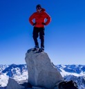
The remaining climb to the summit was a bit rockier and steeper, but still easy class 2 climbing. The final section was a short gully which made for a fun snow climb, and our crampons were perfect here. The gully led directly to the summit which was caked in snow. Surprisingly, the summit was practically windless which was a welcomed relief. We had been getting hammered all the way up by strong winds. 


We had hit the summit during a nice weather window, and stayed for a bit enjoying the views. We had initially thought we'd go for the traverse to Pacific. However, an approaching storm could be see on the horizon, so we bailed on that idea and began our descent down the ridge. We took the same route and made it back to our vehicles in record time. Thumbnails for uploaded photos (click to open slideshow): 


|
| Comments or Questions | |||||||||
|---|---|---|---|---|---|---|---|---|---|
|
Caution: The information contained in this report may not be accurate and should not be the only resource used in preparation for your climb. Failure to have the necessary experience, physical conditioning, supplies or equipment can result in injury or death. 14ers.com and the author(s) of this report provide no warranties, either express or implied, that the information provided is accurate or reliable. By using the information provided, you agree to indemnify and hold harmless 14ers.com and the report author(s) with respect to any claims and demands against them, including any attorney fees and expenses. Please read the 14ers.com Safety and Disclaimer pages for more information.