| Peak(s): |
San Luis Peak - 14,023 feet Handies Peak - 14,058 feet Redcloud Peak - 14,037 feet Sunshine Peak - 14,004 feet "Sundog" - 13,437 feet |
| Date Posted: | 08/12/2008 |
| Modified: | 07/27/2017 |
| Date Climbed: | 08/09/2008 |
| Author: | CarpeDM |
| Peak(s): |
San Luis Peak - 14,023 feet Handies Peak - 14,058 feet Redcloud Peak - 14,037 feet Sunshine Peak - 14,004 feet "Sundog" - 13,437 feet |
| Date Posted: | 08/12/2008 |
| Modified: | 07/27/2017 |
| Date Climbed: | 08/09/2008 |
| Author: | CarpeDM |
| San Juan 5: So very tired |
|---|
|
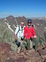
Since I cut my hand badly a couple of weeks ago - requiring 5 stitches - I had to postpone a trip to the Crestones scheduled for the first weekend of August. But that shouldn't stop me from getting some of the easy walk-ups - where I shouldn't need my hands for climbing. So I went down to the San Juans to try for 4 peaks in 3 days. I actually managed a bonus peak, too! August 9, 2008 San Luis Peak from Stewart Creek Roundtrip Length: 13 miles Elevation Gain: 3,600 ft Trailhead: 6:20am Summit: 9:25am Trailhead: 12:20pm This mountain was quite tricky, so let me help you out a bit: Step 1: Make your way to the trailhead Step 2: Hike the well-maintained trail to the summit Step 3: When you get to the summit - here's the tricky part - hike the well-maintained trail back to the trailhead But seriously, make sure you allow plenty of time to get to the trailhead. There are a lot of miles on (good) dirt/gravel roads through open range. It so happened that on the day that I chose to do the most remote 14er in the state, a 14er finisher from Vail brought more than a dozen of his friends to help him celebrate. Adding in the party of 5 from Texas, there were about 20 people on the summit at the same time. C'est la vie. I had heard so much about the wildlife on this hike. Except for a couple of ground squirrels and a few birds, I saw zero wildlife - not even the ever-present marmot. To top it off, it was cold and windy on the summit and clouds were starting to gather. But it was still a beautiful hike and a good warm-up for the next couple of days (WOW! I can't believe I called 13 miles on a 14er a warm-up! That's crazy-talk!) Gnarly bristlecones line the trail shortly before the last creek crossing  A beaver pond along the trail  August 10, 2008 Handies Peak from Grizzly Gulch Roundtrip Length: 8 miles Elevation Gain: 3,650 ft Trailhead: 7:05am Summit: 10:05am Trailhead: 12:50pm Even colder and cloudier than San Luis. Of course, it was sunny and warm all afternoon. Rrrrrrr. Another beautiful hike, though. Probably the most beautiful hike I have ever done. Didn't start until 7:05. The dog got me up in the middle of the night with his shivering. After I let him out to move around a bit and conduct a little business, he was okay, but I had trouble getting back to sleep. Sleeping at altitude probably had a lot to do with that. Also, although San Luis was the easiest 13 miles I've ever done, I felt every one of those miles while climbing Handies. Uncompahgre is in the clouds to the left of Whitecross Mtn  Still no Uncompahgre sighting  Finally! The Unmistakable Incomparable Uncompahgre  Wildflowers and streams in the basin     August 11, 2008 Sunshine via Redcloud - with descent via Sundog Roundtrip Length: ~10 miles Elevation Gain: ~5,200 ft Trailhead: 6:30am Redcloud summit: 9:30am Sunshine summit: 10:30am Sundog summit: I lost track Trailhead: 2:20pm So on Sunday evening - after it seemed everyone had gone back to their weekday lives - a Forester pulled up to the Silver Creek parking area as the sun was going down. I got to talking with the couple - Roger and Brenda. They too were planning to do Redcloud and Sunshine on Monday, but she was going to return the standard route with their two dogs while he came down via Sundog (he's really into climbing 13ers) - and he was looking for some company. I had always liked the idea of doing Sundog while I was there, but my research on it consisted mainly of looking over the map in Roach many moons ago. So here was a chance to tag along with an experienced and prepared climber and get a bonus peak. They had planned to start at 4am and go slowly, and I had planned to start at about 5am. Of course, 5am for me turned out to be about 6:30am for everyone else in the Mountain time zone. So I thought there was no way I'd be able to catch up to them in time to have a partner for Sundog. After coming off my first back-to-back 14er days, the trip up Redcloud went more quickly than I could have dreamed. Where the trail closely parallels Silver Creek, there was some awe-inspiring avalanche debris. Otherwise, the hike up was enjoyable, chilly, but uneventful. Once on Redcloud again, I finally actually got to see some other peaks around me. You see, I had climbed Redcloud last year. And with the two preceding days, this was my fourth day ever climbing in the San Juans, and first day that wasn't really overcast. (Okay, so I did finally see Uncompahgre on the Handies descent.) Who knew Wetterhorn and Uncompahgre were right over there?!  There were other peaks (and pictures of peaks), but Redcloud was even colder and windier than San Luis and Handies, so I hastened down to the saddle - where, lo and behold, I came across Roger and Brenda! I was able to catch them only because they had actually started at 5:45am, and Brenda had just returned from Sunshine while Roger had waited on the saddle with their two dogs. So it turned out to be really good timing. I followed Roger up to Sunshine's summit, where we took a short breather (for my benefit) before starting off for Sundog. Sundog was easily the most interesting part of this trip from a climbing perspective. We first descended down Sunshine's west ridge on a faint trail - at some points doing some mild "scree skiing." Next, we traversed northwest over the flat, open plateau. On this plateau, it looked like someone had cleared the rocks out in several places; there were very discernible rockless rectangles. It looked like it would have been a lot of work since there were many small rocks to remove. Maybe they are the San Juan's version of crop circles. After this plateau, we came to the connecting ridge. We hiked basically northwest along this ridge - climbing on or around a gendarme or two. At times there was some dramatic exposure. Well, it looked crap-inducing in places, but I never really felt exposure. I would definitely say the ridge was not quite class 3 since I used my hands only occasionally - and that was really just for balance. And the rock was pretty solid in the places where it really needed to be (Always check your hand and foot placements carefully!). After a bit of this, you turn more to the north and do some more ridge running. At the end of this more north facing section, Roger reached a high point where he stopped to wait for me. Having not looked at my map in a while, I was thinking that he was probably on Sundog's summit. But when I joined him, I saw Sundog hiding behind him over another bit of ridge. Sigh. Eventually, we made it to Sundog and took a long break to enjoy the nice (finally!) weather and to give Okie some rest. Oh, yeah, I too enjoyed the rest immensely. As I finished one of the more interesting parts of the ridge scramble, I thought, I should have had my camera trained on Roger for that. Here he is (dead center) on a more typical part of the ridge  Roger and the route from Sunshine to Sundog - more or less  Okie and me on Sundog with my new Uncompahgre fixation  The next task was some "gravel glissading" down Sundog's steep north face to where the slope eased up a bit before heading into a forested north ridge. This was pretty straight-forward, but by now, the whole endeavor was wearing thin. Up to the point where we got to the forest, there had been faint trail segments all the way that made route-finding pretty easy. But from treeline, we first started bushwhacking straight north down the ridge. However, we soon encountered a fair amount of tree-fall, so we adjusted our bushwhack to the steep east side of the ridge to reach the drainage below. While relatively steep, it was short and on soft pine-needle ground. We had seen a trail alongside this drainage - both on topo maps and from up above. It turns out this is the trail used in the Northwest Face route to Sunshine (see the route page). So the trick was to find the best way to run into it and hope that the stream crossing(s) didn't leave us waterlogged. Once we got to the drainage, we had to parallel it a short way before finding the trail. But it was a good trail - easily spotted once you come onto it - that led right back to Silver Creek and the standard route. I don't remember seeing the 4 or 5 foot cairn that marked where this trail cuts off from the standard route - either on the trip up that morning or on the trip up Redcloud last year. Hmmm. It seems so hard to miss now. But I can see how it would be difficult to spot the actual trail. While the cairn is easy to spot, the stream crossing to get to the trail was not at all obvious. If you're going up this way, getting across the stream here and finding that trail is key. Once back at the trailhead, I tried to take a nap, but the biting flies were just unbearable!! I'm pretty sure I heard them laughing at me as I reached for the Deep Woods Off. I tried piling myself and the dog into the tent, but even after removing the rainfly it was too hot inside. So I loaded the dog into the car and got the AC going for a good 20 minutes. Finally, I broke down the tent in a heap and a hurry all the while flailing wildly at the 5 billion flies around me. A modified topo with our approximate Sundog route in red.  It may sound like all I did was a lot of bitching about this trip - the weather, the lack of solitude on San Luis, the lack of wildlife, the flies - but overall it was a great trip: 1. The San Juans are beautiful! 2. The hiking is on well-maintained, easy trails. 3. Sundog made the hiking interesting. I'm really glad I had the chance encounter with Roger and Brenda and the opportunity to follow a great hiking partner down via Sundog - something I probably would not have tried solo. 4. The dog getting me out of bed in the middle of the night allowed me to enjoy the amazing night sky! 5. I had never hiked 14ers on back-to-back days, let alone on back-to-back-to-back days. So I learned that my hiking limits aren't where I thought they were. Dad always says, "Know your limits." Well, I hope to recognize them shortly before I reach them. 6. Also, I think that hiking on consecutive days helped with my pacing. I finally found the low gear that allowed me to hike continuously at a sustainable pace. 7. I finally found out what it takes to wear out the dog (for more than a few hours). 8. And I got to be an uninvited observer at a 14er finisher's celebration. Congratulations again to the guy from Vail! PS: I think in my haste to escape the flies, I left my maroon & white cooler in the Silver Creek parking lot. If you find it, please give it a good home. Thumbnails for uploaded photos (click to open slideshow): ")
")
")
")
")
")
")
")
")
")
")
")
")
")
|
| Comments or Questions | ||||||||||||||||||
|---|---|---|---|---|---|---|---|---|---|---|---|---|---|---|---|---|---|---|
|
Caution: The information contained in this report may not be accurate and should not be the only resource used in preparation for your climb. Failure to have the necessary experience, physical conditioning, supplies or equipment can result in injury or death. 14ers.com and the author(s) of this report provide no warranties, either express or implied, that the information provided is accurate or reliable. By using the information provided, you agree to indemnify and hold harmless 14ers.com and the report author(s) with respect to any claims and demands against them, including any attorney fees and expenses. Please read the 14ers.com Safety and Disclaimer pages for more information.