Download Agreement, Release, and Acknowledgement of Risk:
You (the person requesting this file download) fully understand mountain climbing ("Activity") involves risks and dangers of serious bodily injury, including permanent disability, paralysis, and death ("Risks") and you fully accept and assume all such risks and all responsibility for losses, costs, and damages you incur as a result of your participation in this Activity.
You acknowledge that information in the file you have chosen to download may not be accurate and may contain errors. You agree to assume all risks when using this information and agree to release and discharge 14ers.com, 14ers Inc. and the author(s) of such information (collectively, the "Released Parties").
You hereby discharge the Released Parties from all damages, actions, claims and liabilities of any nature, specifically including, but not limited to, damages, actions, claims and liabilities arising from or related to the negligence of the Released Parties. You further agree to indemnify, hold harmless and defend 14ers.com, 14ers Inc. and each of the other Released Parties from and against any loss, damage, liability and expense, including costs and attorney fees, incurred by 14ers.com, 14ers Inc. or any of the other Released Parties as a result of you using information provided on the 14ers.com or 14ers Inc. websites.
You have read this agreement, fully understand its terms and intend it to be a complete and unconditional release of all liability to the greatest extent allowed by law and agree that if any portion of this agreement is held to be invalid the balance, notwithstanding, shall continue in full force and effect.
By clicking "OK" you agree to these terms. If you DO NOT agree, click "Cancel"...
Peak: Snowmass Mountain
Route: S Ridge, Descent of West Face
RT Distance: 8.8 Miles
Gain: 4,400 Feet
Participants: stevevets689, Dominic, Nathan, Nick
Google Earth image of Snowmass Mountain. The green line is our ascent route, red our descent.
I can thank my Gunnison Basin Public Lands map for bringing me and my friends to this route, far from my favorite. I was looking at it and noticed that it was possible to drive to the Lead King Basin area from Gunnison without having to go around the West Elk Wilderness (a VERY long drive). My friend Dom and I had been planning on hiking something that Sunday and when I figured out that Snowmass Mountain was closer than I thought, I suggested that we go for it. Dom was in. Later, my roommate Nathan found out we were going and decided to join in. Finally, on Saturday, all three of us were at an ascending and rappelling training for SAR and were talking about it when our friend Nick overheard. He had plans but wasn't sure if they were going to work out so he decided to go as well.
Saturday afternoon at around 4:00 we left Gunnison in Dom's Jeep and headed north, arriving at the trailhead going on 8:00. We got camp set up, Nathan built a fire, and we lounged around eating rice and baked potatoes until after 9:00 when I crawled into my zero-degree bag and read some of Touching the Void. I slept well.
The night before
5:00 AM came with a brisk morning. I got out of my tent and woke everyone else up, then proceeded to get ready for the climb. I was ready before anyone else but I didn't mind waiting while they cooked oatmeal and finished off their packs. We were walking along the trail by six. There was enough light from the stars and pre-dawn light for us to turn our lights off and put them away.
We hiked up the valley, switchbacking our way into the basin below Snowmass Mountain. Dom was a little behind the rest of us and periodically we would stop and wait for him. We attributed this to the length of our legs compared to his. Eventually, however, Dom started to slow down considerably. I hung back to hike with him as he hypothesized that he still wasn't fully acclimated to living in Gunnison. We made slow progress. I don't remember exactly what time it was when we arrived at Little Gem Lake but I was already worried about the time. Everyone was still go for S Ridge so we cut off the trail and headed east.
Dom hiking near Geneva Lake, Snowmass Mountain above
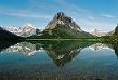
Looking back over Geneva Lake
The route to gain the ridge had looked dubious from a distance but looked much more doable once we were closer. There are two deeply inset gullies that run up to the ridge and they look to be the same in pitch and difficulty. Nick and Nathan chose the left one, Dom and I the right. Scrambling up the talus and boulders to the gullies was already a bit loose and tedious but it was only a taste of the difficulties further on. We carefully picked our way up the gullies, Dom still lagging behind a ways, and eventually met up again on the ridge. I asked Dom if he was still good for the summit, since this was the last good place to turn back, and he said yes so we continued.
Little Gem Lake
Snowmass Mountain from near Little Gem Lake
Approaching the chutes
Looking up the right chute from about halfway up
Looking back down the chute
Hagerman Peak from S Ridge
The climbing on the ridge was mostly class 3 and maybe a little class 4 in places, and loose rock perched in very inconvenient places. We did our best to skirt any looseness and tried to make the climb as easy as possible, but at times I really felt like I was climbing an alpine ridge on some famously difficult route. Dom's progress continued to slow and I really started to worry as the sun rose high in the sky and cumulus clouds began to form seemingly out of nowhere. We couldn't just turn back; our best way down was over the summit and down the West Face. The ridge felt longer than it really is just because of our speed. Nathan, Nick and I arrived at the summit at last, but it was 12:30. Our slow progress and the burning sun put us nearly out of food and water already. The situation was really starting to look sketchy.
Looking up the ridge at a tower on the ridge
Some of the easier climbing, Nick is on the horizon left of center
Dom in front of the rest of the way to the top
Pyramid Peak and the Maroon Bells from near the summit
Dom arrived on top after 1:00. We made quick business of summit rituals and started descending. Amazingly we were the first of the day to summit and passed several people on their way up the face. I had felt relieved to arrive on top since we could finally work on getting down, but the descent was far longer and more tedious than I had thought it would be. Everything was loose and it was all I could do to not send giant rocks tumbling down the gully. Nick descended quickly and Nathan behind him. Tired, hungry and thirsty I started to weaken and slow down. I focused 100% on what I was doing.
A long ways down
Time passed and I caught up to Nathan, taking a breather and trying to summon some energy from some corner of his being. He hadn't packed enough food and I had been sharing with him. We ate the last of what I thought I had and he asked me where Dom was. I had seen him a while ago, not far behind me, but now he was nowhere in sight. We waited for a little while but it started to cool off and the clouds were building. That gully is no place to be in a storm, lightening or no. Dom had earlier insisted on us going at our own pace and allowing him to catch up so we started down again.
Somewhere around 3:00 we noticed cairns leading off to the right to avoid a drop-off in the gully. In case Dom was close behind we stayed there for a little while to make sure he noticed the turn. Nick was already far below, waiting for us on a boulder. Once again we decided it would be better for us to just get off the face before a storm came in, so we got going. We traversed across rocks and descended to the grassy spot that Bill marks in his route description. Carefully we got down some slick slabs and walked down talus to join Nick. Nick quickly expressed his desire to get out of there as soon as possible and we discussed the situation. Dom was still nowhere to be seen, and all we had to go off was another hiker's message from him saying, "He says he's alright and slowly coming down." Scenes from Touching the Void were going through my head and I tried to keep positive. We moved a little further down the slope to try to get a better perspective on the gully and finally we saw Dom in his red shirt. He had just gotten to the turnoff in the gully. We loudly gestured for him to turn and he did, but he was moving very slowly. Nick and Nathan headed for the safety of the trees while I waited. It was around 4:00.
Storm's coming in
Looking back up at the face
I waited. Dom moved across to climbers' right. A storm started dropping a snow-hail kind of precipitation down and I put my coat on. Dom made his way down the grass. Tripped up. Got up and kept going. I got tired of sitting and doing nothing, put my pack on, and started hiking up to meet him. It was close to 5:00 when we met up, and I asked how he was doing. He muttered, "Alright. I passed out on the way down, don't know how long I was out." I couldn't believe it. He said he was extremely dehydrated, and when he came to he was next to a stream so he filtered three liters of water. It was already gone, meaning he had drunk 6 liters through the course of the day. I couldn't fathom passing out after drinking that much water especially since I was running off less than two liters and still doing alright. I hiked with him as he talked about what he could remember, and we got to a stream and filtered more water for both of us. He was still somewhat disoriented and kept stumbling. We estimated that he had been out for around an hour, and decided that someone "up there" must really like him since he woke up with a stream of water in front of his face. He could have just as easily dropped off a big enough edge to kill him.
The trail out went slowly as Dom struggled to keep his balance. He kept drinking water and I started to wonder if maybe he had drunk too much. On one break I found a power bar in my pack that I had forgotten about and had him eat it. I think that helped him and he regained some of his balance. We were able to hike faster after that. I stopped encouraging him to drink water as I formulated a new idea: he didn't have enough electrolytes in his system. The further we hiked the better he seemed to be, and he wasn't drinking water anymore. With his situation improved, other thoughts started pouring through my mind, chiefly feelings of guilt for not staying with Dom on the descent. I wondered what we could have done better. In all reality we probably should've turned around at the top of the chutes gaining the ridge, but once we started climbing the ridge and made it past some of the climbing problems, there weren't any good escapes. The face has cliffs at the bottom and there was no way to know a good way past them except on the most traveled route. Even if I had stayed with Dom on the descent, what could I have done? It seemed harsh but perhaps we had done the best. At least I had stayed where I could see him and waited for him to come down.
Dom and I caught up with Nick and Nathan on the switchbacks leading back to the Jeep and we all walked the rest of the way together. Dom seemed to be mostly back to his normal self by the time we got back to camp at 7:00 and we loaded up the Jeep. Dom drove the rough road out to Marble where I could call my parents and make sure they weren't sending Search and Rescue after us. Dom drove us back over McClure Pass and I took the wheel for the rest of the way back to Gunnison where we arrived at not quite 11:00. I remember dropping my stuff in a massive heap next to my bed and getting into it, then nothing else.
Cascades near the trail on the way out
This climb left me with new rules for climbing with people I haven't climbed with before. It doesn't matter about what they say their experience level is (Dom has climbed Mt. Shasta is a great rock climber) if I don't know them then we start with something where turning around is always an option. I still haven't thought through everything that happened on this trip and don't know if we made all the right decisions; in fact I think there were several things we overlooked. All I can come away with is the experience for what it is, and some ideas of how to do things differently in the future. I don't plan on returning to Lead King Basin for quite some time... Hagerman Peak isn't happening anytime soon anyway.
For more pictures from this climb, please visit my online photo album at:
Thumbnails for uploaded photos (click to open slideshow):
A story of your own. You were one of the SAR volunteers who got my friend ”the professor” out from Kit Carson. I learned much from that trip and two subsequent trips with new climbing partners. It is so hard to guage everyone‘s ability and know when to say when. Good job for staying close enough to your friend and helping him get out.
quite the epic day! Glad you friend is ok. Congrats on getting Snowmass via that route despite all the extraneous adventures of the day. I can relate to your feelings about the Lead King Basin..I feel the same way about the Apostle/Ice mtn area. Hopefully we can make it down your way sometime soon.
glad to see you were constantly evaluating the situation as it progressed and i‘m sure you will put this knowledge to good work on future climbs. constant evaluation is invaluable in the mountains.
nice job on getting snowmass! that‘s no small feat.
Snowmass is one tough mountain; congrats on making it. And kudos to you for hanging in there with your buddy; it sounds like maybe he shouldn‘t have even been there! BTW, don‘t give up on Lead King Basin: It‘s a gorgeous place, and Hagerman is still on my to-do list as well.
We climbed up and down the route that you came down. It's a heck of a trail. Good job. We heard the "S" route might have been the better way. We had good weather up and back however, when we got to Geneva we ran into a small group that was having a memorial for a climber that had died coming down that several years ago. Those things always make you think. Thanks a lot on the info regarding over-hydrating. I had not heard of that. So glad that everything worked out for you and your group!
is an electrolyte imbalance in which sodium levels in the blood become too low. The symptoms appear similar to dehydration (loss of coordination, slurred speech) but treating it like dehydration (drinking more water) can be fatal. Long distance runners usually are the ones who get it and misdiagnosis can have dire consequences. Taking electrolyte pills or drinking sports drinks are the easiest ways to avoid it. Good on you Steve for noticing it and having him stop drinking more water.
Caution: The information contained in this report may not be accurate and should not be the only resource used in preparation for your climb. Failure to have the necessary experience, physical conditioning, supplies or equipment can result in injury or death. 14ers.com and the author(s) of this report provide no warranties, either express or implied, that the information provided is accurate or reliable. By using the information provided, you agree to indemnify and hold harmless 14ers.com and the report author(s) with respect to any claims and demands against them, including any attorney fees and expenses. Please read the 14ers.com Safety and Disclaimer pages for more information.
Please respect private property: 14ers.com supports the rights of private landowners to determine how and by whom their land will be used. In Colorado, it is your responsibility to determine if land is private and to obtain the appropriate permission before entering the property.


")
")
")
")
")
")
")
")
")
")
")
")
")
")
")
")
")
")