Download Agreement, Release, and Acknowledgement of Risk:
You (the person requesting this file download) fully understand mountain climbing ("Activity") involves risks and dangers of serious bodily injury, including permanent disability, paralysis, and death ("Risks") and you fully accept and assume all such risks and all responsibility for losses, costs, and damages you incur as a result of your participation in this Activity.
You acknowledge that information in the file you have chosen to download may not be accurate and may contain errors. You agree to assume all risks when using this information and agree to release and discharge 14ers.com, 14ers Inc. and the author(s) of such information (collectively, the "Released Parties").
You hereby discharge the Released Parties from all damages, actions, claims and liabilities of any nature, specifically including, but not limited to, damages, actions, claims and liabilities arising from or related to the negligence of the Released Parties. You further agree to indemnify, hold harmless and defend 14ers.com, 14ers Inc. and each of the other Released Parties from and against any loss, damage, liability and expense, including costs and attorney fees, incurred by 14ers.com, 14ers Inc. or any of the other Released Parties as a result of you using information provided on the 14ers.com or 14ers Inc. websites.
You have read this agreement, fully understand its terms and intend it to be a complete and unconditional release of all liability to the greatest extent allowed by law and agree that if any portion of this agreement is held to be invalid the balance, notwithstanding, shall continue in full force and effect.
By clicking "OK" you agree to these terms. If you DO NOT agree, click "Cancel"...
July 12th, 2010 French Mountain - 13,940'
Frasco Benchmark - 13,876'
Casco Peak - 13,908'
TH: Halfmoon Creek (Intersection of FS 1103A)
Partner: SOLO
Distance : 12 miles
Elevation : 4600'
Total Time : 6 hours, 15 min
I knew in advance that my weekend was going to be "mountain-less" due to plans we had around home. Looking to head off this unfortunate circumstance, I decided to take off Monday so I could still get to the mountains. I had played around with a couple options, but still hadn't made up my mind where I wanted to head. The previous weekend I was able to collect Holy Cross Ridge and Holy Cross (Sat) and Grizzly Pk A (Mon) so I kind of wanted to keep with the centennial theme, but where...?
On Sunday as I sat in my recliner skimming through Roach's book looking for ideas, I got a text from Greenhouseguy saying he was on "Lackawanna". (See Greenhouseguy's "Lackawanna Peak" report ) That got me thinking about the French group. Last time I was in that area it was packed with snow, seemed like I was due for a return.
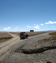
Since I couldn't drive there the night before, I got up quite early and headed for Halfmoon road. I was much more sleepy than normal for an early morning drive, so I decided to pull into the Elbert TH to catch a quick nap and wait for the sunrise. I felt much better after a 30 minute snooze and head up the final 2 miles to the turnoff where I would park. (Intersection where FS 1103A breaks from CO 11.) With 4 wheel drive, one is able to ford the stream and continue another mile to a second stream crossing. Yes, I had 4WD, however I chose not to continue past the lower trailhead. I'm a wimp when it comes to driving rough roads...I'd much rather hike it.
Photo from later in the day showing the first creek crossing that I parked at.
I parked and started up the road right at 6:00 AM. Wading through the stream was not fun, and it took a good mile for the feeling in my toes to come back. The first few miles follow the Halfmoon Road as it ascends up to Iron Mike Mine, located at 12,560'. The road is quite mellow despite the 2,000' it ascends, and I was able to make decent time. I reached Iron Mike Mine and slapped on some sunscreen.
Elbert's backside from the road to Iron Mike Mine. First views of French from just after treeline. Final segment of the road, just before Iron Mike Mine.
Leaving the road right by an old cabin, I dropped slightly towards a small creek before starting the ascent to the ridge. The slope used to gain the ridge of French appears quite steep from the mine, and it was. I had trouble finding solid footing in some spots, and also had to stop quite often to rest my legs. I found tracks in one spot where a mountain goat had lost its footing, so that made me feel a little better. I eventually reached the ridge between Frasco BM and French. The summit of French was only a couple hundred yards from this saddle, and I reached the summit of French around 8:45.
The slope up to French as seen from Iron Mike. I ascended straight up to the low portion just left of the summit. Casco rising over the old cabin. I left the road at this cabin. Example of the slope up to French. Frasco BM from the summit of French.
I spent a couple minutes on the summit grabbing a snack and squinting to see if I could make out anyone on top of Elbert. I then descended back to the saddle that I had ascended from and began to head up towards Frasco BM. There really were no difficulties on this portion of the ridge and I arrived at the summit in about 30 minutes from French. The summit is unranked, however it was here that I saw the only benchmark of the day. (Then again, I wasn't really looking too hard on the other summits.)
Approaching the summit of Frasco BM. Frasco Benchmark's Benchmark. :-) View of Casco from the summit of Frasco BM.
I only paused for a moment and began the descent to "Fiascol", or the saddle between Casco and Frasco BM. Even though the weather called for great conditions all day in the area, clouds seemed to be building towards the west. I was secretly hoping to summit Bull Hill later in the day, and it looked like I would have to hurry if that was going to happen. The descent towards the saddle had a few sections of fun scrambling and route finding. A couple times I would back track to find the correct way around some of the rougher towers, however most of the time I just tried to stay directly on the ridge. The difficulty stays manageable as long as time is spent to find the best way. (Roach's book states this portion of the route as class 2+, however I have found that most people consider it closer to class 3. I suppose with perfect routefinding you could keep it at 2+.) While on the ridge, some mountain goats below me set off a pretty sizeable rock slide to my right (west). Some clumbsy goats in this area!
Picking the best way around and over some scrambling sections on the descent to the saddle. More ridge. View of Casco from the saddle with Frasco BM.
Casco looked quite impressive once I reached the saddle, however a faint trail led most of the way up keeping the difficulty at class 2. The ascent went quick, and about 100 feet shy of the summit I branched to the right and followed the ridge directly for the rest of the way. Nice, solid and fun. I topped out on Casco at 10:15 and enjoyed a quick sit on the summit boulder that represented the true summit. The perch allowed for some great views of Elbert, LaPlata, and Grizzly from the previous week.
Final summit section of Casco. View of Bull Hill from the summit of Casco.
Still determined to grab at least one more summit, I left Casco and continued down towards the saddle with Bull Hill. The trail was pretty well defined leading all the way down. As I descended, I kept a close watch on the clouds. By the time I hit the saddle, I decided I didn't trust the weather enough and would rather get back below tree-line. Along with being a 4WD wimp, I am also a lightning wimp and would prefer to play it safe. I made a deal with myself that if I descended, I would stop and grab some below additional lower peaks on the drive home. (Hindsight, the weather would have held out for me. Oh well.)
Looking back up at Casco from the descent towards the Bull Hill saddle. Terrain example from where I dropped off the saddle back into the basin.
So from the saddle, I dropped back down towards the Iron Mike Mine and the Halfmoon Road. I had overshot the described route for dropping back into the basin, but the way I descended was just fine. I quickly made it to the road to complete the loop and headed down. I kept up a quick pace heading back down the road, wanting to have as much time as possible to continue hiking later in the day.
Some mining remains. Looking back up at my descent route I used from the ridge. A VERY green descent back towards the road.
On the way down, I saw some bear tracks heading down the road, leading the same way as I was going. They were relatively fresh, as they overlayed my tracks from that morning. I didn't think too much of it and continued on. After a little bit, I continued to notice that the tracks were still there, and that at every water crossing the tracks were becoming more and more wet. Turns out I was gaining on the bear, and I didn't like that. With some of the closed in portions of the road, it was hard to see very far ahead and I was afraid that I might accidentally run up on the bear and spook it. I had accidentally spooked a bear before, and didn't want it to happen again. So I took it slow, assuming that eventually the tracks would turn off the road. Eventually they did, right around the upper TH. I presume he broke left and went down to the brush by the creek.
Final view of French before dropping back below treeline. Casco on the right, my descent saddle in the middle. Photo taken just after reaching treeline. Furry friends are afoot. Scenes from the upper road. Obviously the path of least resistance, which is probably why the bear chose the same path. Almost back to the truck. Picture was taken while in the water.
I reached my truck at 12:15, and after suffering the incredibly cold wade across, headed off to some Jefferson County ranked summits, however I doubt anyone has interest in those...
Time Breakdown:
Truck- 6:00
French Summit - 8:45
Frasco BM Summit - 9:20
Casco Summit - 10:15
Back to Truck - 12:15
--Derek
My GPS Tracks on Google Maps (made from a .GPX file upload):
Very good report. I‘ll have to check this hike out next week when I come down with a 24-hour virus and can‘t make it in to work. Do you think my Saturn could make the creek crossing?
the area is prettier with green grass! 4/2/2015 7:45pm
Seeing bear tracks must've been pretty cool.
One thing that worked out better for us - low water level at the creek crossing, was very doable with boulder and log hopping.
6.15 RT - holy smoke you were booking this
Caution: The information contained in this report may not be accurate and should not be the only resource used in preparation for your climb. Failure to have the necessary experience, physical conditioning, supplies or equipment can result in injury or death. 14ers.com and the author(s) of this report provide no warranties, either express or implied, that the information provided is accurate or reliable. By using the information provided, you agree to indemnify and hold harmless 14ers.com and the report author(s) with respect to any claims and demands against them, including any attorney fees and expenses. Please read the 14ers.com Safety and Disclaimer pages for more information.
Please respect private property: 14ers.com supports the rights of private landowners to determine how and by whom their land will be used. In Colorado, it is your responsibility to determine if land is private and to obtain the appropriate permission before entering the property.


")


 Photo from later in the day showing the first creek crossing that I parked at.")
 Elbert's backside from the road to Iron Mike Mine.")
 First views of French from just after treeline.")
 Final segment of the road, just before Iron Mike Mine.")
 The slope up to French as seen from Iron Mike. I ascended straight up to the low portion just left of the summit.")
 Casco rising over the old cabin. I left the road at this cabin.")
 Example of the slope up to French.")
 Frasco BM from the summit of French.")
 Approaching the summit of Frasco BM.")
 Frasco Benchmark's Benchmark. :-)")
 View of Casco from the summit of Frasco BM.")
 Picking the best way around and over some scrambling sections on the descent to the saddle.")
 More ridge.")
 View of Casco from the saddle with Frasco BM.")
 Final summit section of Casco.")
 View of Bull Hill from the summit of Casco.")
 Looking back up at Casco from the descent towards the Bull Hill saddle.")
 Terrain example from where I dropped off the saddle back into the basin.")
 Some mining remains.")
 Looking back up at my descent route I used from the ridge.")
 A VERY green descent back towards the road.")
 Final view of French before dropping back below treeline.")
 Furry friends are afoot.")
 Casco on the right, my descent saddle in the middle. Photo taken just after reaching treeline.")
 Scenes from the upper road. Obviously the path of least resistance, which is probably why the bear chose the same path.")
 Almost back to the truck. Picture was taken while in the water.")