Download Agreement, Release, and Acknowledgement of Risk:
You (the person requesting this file download) fully understand mountain climbing ("Activity") involves risks and dangers of serious bodily injury, including permanent disability, paralysis, and death ("Risks") and you fully accept and assume all such risks and all responsibility for losses, costs, and damages you incur as a result of your participation in this Activity.
You acknowledge that information in the file you have chosen to download may not be accurate and may contain errors. You agree to assume all risks when using this information and agree to release and discharge 14ers.com, 14ers Inc. and the author(s) of such information (collectively, the "Released Parties").
You hereby discharge the Released Parties from all damages, actions, claims and liabilities of any nature, specifically including, but not limited to, damages, actions, claims and liabilities arising from or related to the negligence of the Released Parties. You further agree to indemnify, hold harmless and defend 14ers.com, 14ers Inc. and each of the other Released Parties from and against any loss, damage, liability and expense, including costs and attorney fees, incurred by 14ers.com, 14ers Inc. or any of the other Released Parties as a result of you using information provided on the 14ers.com or 14ers Inc. websites.
You have read this agreement, fully understand its terms and intend it to be a complete and unconditional release of all liability to the greatest extent allowed by law and agree that if any portion of this agreement is held to be invalid the balance, notwithstanding, shall continue in full force and effect.
By clicking "OK" you agree to these terms. If you DO NOT agree, click "Cancel"...
First of all I would like to thank Wesley for his help with route information. With out his help this would have been difficult to find.
Sean and I decided to hook back up for another trip up Longs, this time through a route neither of us had done before. Our original plan was to attempt a full traverse of Mills Cirque, starting with the Iron Gates of Mount Meeker and finishing on Mount Lady Washington all the while staying as close to the cirque as possible. We meet up about 1 mile down from the parking lot (by far the most people we had ever seen at Longs) at around 4 am. After a gear swap and stretch we were on our way by 4:20am. Our gear consisted of one 70 meter rope, a few runners and quick draws, 5 cams and a few stoppers and tri-cams. Red=Climb Blue=Rappels
When we reached Chasm Lake basin we opted to ascend the normal Loft route and continue the original route without hitting Meeker. I've most often heard this rout called "The Beaver" so I'll stick with that. We followed surprisingly few people up the Loft and continued towards the summit of Southeast Longs (Beaver).
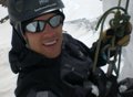
Upon reaching the summit SE Longs, Sean had already located the rappel station. This is located about 20 feet east of the summit block. It is down 6 feet from the ledge. Beaver summit behind Sean
Sean quickly set up and inspected the 5 or 6 runner already there. Wesley had placed the black runner just a week or two prior. We fed our rope through both the quick link and the rappel ring already there. Rap Station
This was the exciting part we had been aching for! Hating to go second on a rappel I asked to drop in first. A dozen deep breaths later I was hanging off the Beaver swaying in the winds.
We had both read that this Rap can be done with a 60 meter rope and would agree, but 70 provided extra comfort room. Sean followed suit and we found ourselves with a 20 foot down climb to reach the bottom of the Notch. Sean coming down
There was another rap station backed up with a piton right where we landed, but decided not to take advantage of it. second rap piton
From the Notch we moved directly north to a ledge system that swung around to climber right. (northeast)
The ledge was Very exposed and had devastating consequences if a fall was taken. Exposure below
After about 20 feet on this ledge you are presented with a rather large dihedral with ample room for a bottom belay.
The climb from here is called the "Stepladder". It rather keeps to its name. Lots of holds at relatively low angle. Upon reaching the route we quickly decide it was within our abilities to free climb the pitch, plus the rope was already in my pack. We started left and diverted right before a skinny chimney choked us out. The moves right were a little more slabby but had plenty of good holds even in trail runners. Route Up as described John with a nice look down.
The angle drops and deposits you at Longs Peaks South ridge.
From here it's a short 2nd/3rd class hike up. Sean above the Stepladder on South ridge
We took quite a long break on top, chatting with a nice couple about the history of this amazing peak. With the weather still holding we started on down the North Face for our final rappels. The route from the cables
We passed several groups heading up and observed two folks gaining the top of Mary's Ledges. Group coming up
The two who climbed Mary's Ledges decided to call it a day and meet us at the top of the Cables Route. Turns out the male in the group was none other than Gary Neptune, owner of Neptune Mountaineering! What a nice Guy! Mr. Gary Neptune belaying Mary's Ledges
The leader of a party of four ascending the dihedral was kind enough to let Sean and I rap down off of his rope, which he tied off at the top bolt. One more rap from a lower bolt and we were on our way down. Sean rapping the icy cables cables traffic jam
Just a long 5.5 mile slog down an all too familiar trail. Thanks to Sean for his words of wisdom and kind company! Amazing route indeed!
Sean Rapping down:http://www.youtube.com/watch?v=ZxjxZOoSK-k
Thumbnails for uploaded photos (click to open slideshow):
This is a super-cool way to ascend Long's Peak. Sean and yourself really put some thought into this route. The rap off 'The Beaver' and upclimbing the 'Stepladder' must have rocked! After reading this, John, you've really got me intrigued in the notch portion.
Would this be a route you'd be interested in repeating?
Nice work in getting this done! And to meet gary Neptune to boot! What a way to end the day! 8)
John/Sean: Great job and cool report/pics. Longs rarely fails to deliver, no?
-Tom
PS: IMO that second rap pin you photographed is ready to pull, not safe. I can see why you chose to forego using it. Just my opinion.
I would say this is a repeatable route and another fav to add to the growing list of routes on Longs. The Rap and stepladder made the route extremely enjoyable. Summiting and surprising people from that direction adds to the fun. If you guys go back, take another length of webbing for the rap and a new link or rap ring. Plus a knife to remove some of the old webbing. We planned on doing it, but did not have the necessary length of webbing to replace the old.
John, thanks for posting this and for the great company on a fun route.
Glad to see you made it. I was keeping an eye up there from Kiener's but I never saw you guys. We must have just missed you on the rap off the north face because that party was still there when we came down. I'm looking forward to doing this route. Longs has so many to offer!
Glad you guys enjoyed the route. Always fun to do a different route on Longs. I was climbing something between the camel and chasm view but it took a lot longer than planned so I missed you guys. Although I talked to saxmotor and I saw Neptune in the boulder field. That piton looks sketch! I wondered about that second rap station too, might be used to bail to Kiplingers.
was not worth repeating. We made our way around Chasm lake, found some 5.5 to 5.7 on the right that looked decent, climbed a few pitches (only the first was good), ended up on some really lose scree, made our way to the Camel, and on to the Boulderfield. The idea was to see some of Longs, and do a little climbing along the way. And for that purpose, it worked. If we were better climbers, Directissima would have been sweet.
after doing it I would realy like to do the notch coulior. i believe the stepladder is the finish of that route. but yes, very worth while and worth doing again!
I agree with you Tom, forgot to mention, it was backup for a couple runners and a rappel ring wraped around a rock. It was just a few moves to downclimb, dont know why somebody placed so much gear for an easy drop. Thanks Tom! lets get out soon!
We did see a few people just south of the camel on the ridge, could have been you guys. What route were you on? I know of a few lines between chasm view and the camel
Caution: The information contained in this report may not be accurate and should not be the only resource used in preparation for your climb. Failure to have the necessary experience, physical conditioning, supplies or equipment can result in injury or death. 14ers.com and the author(s) of this report provide no warranties, either express or implied, that the information provided is accurate or reliable. By using the information provided, you agree to indemnify and hold harmless 14ers.com and the report author(s) with respect to any claims and demands against them, including any attorney fees and expenses. Please read the 14ers.com Safety and Disclaimer pages for more information.
Please respect private property: 14ers.com supports the rights of private landowners to determine how and by whom their land will be used. In Colorado, it is your responsibility to determine if land is private and to obtain the appropriate permission before entering the property.


 Red=Climb Blue=Rappels")
 Beaver summit behind Sean")
 Rap Station")
 Sean coming down")
 second rap piton")
 Exposure below")
 Route Up as described")
 John with a nice look down.")
 Sean above the Stepladder on South ridge")
 The route from the cables")
 Group coming up")
 Mr. Gary Neptune belaying Mary's Ledges")
 Sean rapping the icy cables")
 cables traffic jam")
 Basic Route Up, Ledge out of view leads to the dihedral behind large flake")
 Leader ascending the Cables")
 John with Rap station marked")
 rap bolt on cables")