14er List Updated to match LOJ
Forum rules
- This is a mountaineering forum, so please keep your posts on-topic. Posts do not all have to be related to the 14ers but should at least be mountaineering-related.
- Personal attacks and confrontational behavior will result in removal from the forum at the discretion of the administrators.
- Do not use this forum to advertise, sell photos or other products or promote a commercial website.
- Troll posts will be removed.
Re: 14er List Updated to match LOJ
Thank you as always sir.
-
CheapCigarMan

- Posts: 571
- Joined: 12/10/2014
- 14ers: 58 2
- 13ers: 108 2
- Trip Reports (1)
Re: 14er List Updated to match LOJ
Thank you Bill.
Am I mistaken or did Sunlight Spire get removed?
Am I mistaken or did Sunlight Spire get removed?
I should be on a mountain

Re: 14er List Updated to match LOJ
The LiDAR study reconfirmed that the Spire is under 14K. I believe LiDAR has its elevation at 13,996.CheapCigarMan wrote: ↑Mon Jun 27, 2022 11:02 am Thank you Bill.
Am I mistaken or did Sunlight Spire get removed?
Peter Aitchison on the risks of rock climbing and mountaineering: "That's life, isn't it? We think the challenge and satisfaction you get from doing this is worth the risks."
"Respect the mountain. Train hard. Hope you can sneak up when it isn't looking."
"The mind is always worried about consequences, but the heart knows no fear. The heart just does what it wants."
"Respect the mountain. Train hard. Hope you can sneak up when it isn't looking."
"The mind is always worried about consequences, but the heart knows no fear. The heart just does what it wants."
-
CaptainSuburbia

- Posts: 1103
- Joined: 10/7/2017
- 14ers: 58 35
- 13ers: 125 9
- Trip Reports (44)
Re: 14er List Updated to match LOJ
Thanks for the update Bill!
Poor Challenger.
Poor Challenger.
Some day our kids will study Clash lyrics in school.
Nothing drives people crazy like people drive people crazy.
Save Challenger Point
Nothing drives people crazy like people drive people crazy.
Save Challenger Point
-
BillMiddlebrook

- Site Administrator
- Posts: 6919
- Joined: 7/25/2004
- 14ers: 58 46 19
- 13ers: 172 44 37
- Trip Reports (2)
- Contact:
Re: 14er List Updated to match LOJ
My pleasure.
Also, the elevations will be automatically picked up by the mobile apps.
Also, the elevations will be automatically picked up by the mobile apps.
"When I go out, I become more alive. I just love skiing. The gravitational pull. When you ski steep terrain... you can almost get a feeling of flying." -Doug Coombs

Re: 14er List Updated to match LOJ
Better not count it unless you hiked up the 50 feet from the top of the liftBillMiddlebrook wrote: ↑Mon Jun 27, 2022 9:31 amMe, too! I must have at least 125 Peak 8 summits.Fisching wrote: ↑Mon Jun 27, 2022 9:22 amI *FINALLY* will get the credit I deserve for summiting Peak 8.BillMiddlebrook wrote: ↑Mon Jun 27, 2022 7:12 am This morning I updated the 14ers.com 14er elevation numbers as well as promoted North Maroon Peak to "ranked" and demoted Challenger Point to "unranked" to match the work done by John Kirk on https://www.listsofjohn.com. I consider John to be the authoritative source for these elevation numbers and his latest work using Colorado LiDAR data has provided us with the most accurate peak elevation data to date. A huge thanks to John and those who helped him finalize these new numbers!!
I'll get the 13er list updated in the next month or so.
After climbing a great hill, one only finds that there are many more hills to climb. -Nelson Mandela
Whenever I climb I am followed by a dog called Ego. -Nietzsche
Whenever I climb I am followed by a dog called Ego. -Nietzsche
-
BillMiddlebrook
- Site Administrator
- Posts: 6919
- Joined: 7/25/2004
- 14ers: 58 46 19
- 13ers: 172 44 37
- Trip Reports (2)
- Contact:
Re: 14er List Updated to match LOJ
^Of course! And I have about about 30 winter summits before they even put the lift in!!!
"When I go out, I become more alive. I just love skiing. The gravitational pull. When you ski steep terrain... you can almost get a feeling of flying." -Doug Coombs

Re: 14er List Updated to match LOJ
Thanks for bringing this up, as I've been wondering about it myself. Might the elevation-based peak lists change again this year?
Going over Challenger is the technically easiest way to climb Kit Carson Peak, so I expect it will still play a role.
=============================================
https://listsofjohn.com/m/Candace+Skalet
https://peakbagger.com/climber/climber.aspx?cid=29263
https://listsofjohn.com/m/Candace+Skalet
https://peakbagger.com/climber/climber.aspx?cid=29263
-
bdloftin77

- Posts: 1094
- Joined: 9/23/2013
- 14ers: 58 1
- 13ers: 58
- Trip Reports (2)
Re: 14er List Updated to match LOJ
Yeah, I'm not sure exactly when they'll officially switch over to the 2022 NAPCG datum - they're finalizing calculations, etc this year. So far, the lidar point cloud tiles have been in NAVD88 (corresponding geoid is GEOID12B or GEOID18). Haven't talked with John yet about this switch, since it hasn't been relevant yet.
Looking at the NOAA website, sounds like there's a delay in the release of the new datum: https://geodesy.noaa.gov/datums/newdatu ... ease.shtml
First question in FAQ, release might not officially happen til 2024 or 2025, with airborne gravity research flights still occurring in 2023: https://geodesy.noaa.gov/datums/newdatu ... tums.shtml
For more info, you can browse the main page: https://geodesy.noaa.gov/datums/newdatums/index.shtml
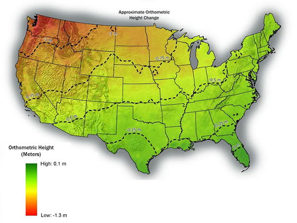
And yes, it looks like the new definition of where sea level is based on equal gravity across the globe will lead to positions in Colorado being lower than previously measured by 0.5 to 0.75 meters (~1.6 to ~2.5 ft). This will lead to the eventual demotion of some very low peaks to the lower elevation threshold. We have estimates, but won't officially know how big this elevation drop will be til they release the new datum.
Approximate elevation change map: https://geodesy.noaa.gov/datums/newdatu ... eights.jpg
Right now I'm just rolling with what we have and what's currently being released to the public - NAVD88 based on GEOID12B and GEIOD18, which are within a few cm of each other.
And thank you, Bill!!
-
DArcyS
- Posts: 947
- Joined: 5/11/2007
- 14ers: 58
- 13ers: 544
- Trip Reports (3)
Re: 14er List Updated to match LOJ
I've been harping on LiDAR not removing the inherent uncertainty involved in defining climbing lists, whether it be due to the uncertainty of the measurements or the uncertainty of how a peak is defined. Even with the 2022 NAPCG datum and whatever uncertainty that may reduce, there will always be uncertainty to the exact sea level due to increasing sea levels (at least in the near future). In my Internet search to find a quick answer to the confidence intervals associated with measuring sea levels, I found this (the point being that using LiDAR to define peak lists down to the foot or inch is subsumed by natural geologic processes over time):bdloftin77 wrote: ↑Tue Jun 28, 2022 8:37 amYeah, I'm not sure exactly when they'll officially switch over to the 2022 NAPCG datum - they're finalizing calculations, etc this year. So far, the lidar point cloud tiles have been in NAVD88 (corresponding geoid is GEOID12B or GEOID18). Haven't talked with John yet about this switch, since it hasn't been relevant yet.
Looking at the NOAA website, sounds like there's a delay in the release of the new datum: https://geodesy.noaa.gov/datums/newdatu ... ease.shtml
First question in FAQ, release might not officially happen til 2024 or 2025, with airborne gravity research flights still occurring in 2023: https://geodesy.noaa.gov/datums/newdatu ... tums.shtml
For more info, you can browse the main page: https://geodesy.noaa.gov/datums/newdatums/index.shtml
And yes, it looks like the new definition of where sea level is based on equal gravity across the globe will lead to positions in Colorado being lower than previously measured by 0.5 to 0.75 meters (~1.6 to ~2.5 ft). This will lead to the eventual demotion of some very low peaks to the lower elevation threshold. We have estimates, but won't officially know how big this elevation drop will be til they release the new datum.
Approximate elevation change map: https://geodesy.noaa.gov/datums/newdatu ... eights.jpg
Right now I'm just rolling with what we have and what's currently being released to the public - NAVD88 based on GEOID12B and GEIOD18, which are within a few cm of each other.
And thank you, Bill!!
- SeaLevelVariation.PNG (109.29 KiB) Viewed 3959 times

Re: 14er List Updated to match LOJ
You may have been harping on the wrong thing, since the "ranked" lists that you're referring to are defined by the arbitrary metric of 300 feet, not whatever means is used to arrive at the most definitive categorization of peaks by that metric.DArcyS wrote: ↑Wed Jun 29, 2022 11:31 am I've been harping on LiDAR not removing the inherent uncertainty involved in defining climbing lists, whether it be due to the uncertainty of the measurements or the uncertainty of how a peak is defined. Even with the 2022 NAPCG datum and whatever uncertainty that may reduce, there will always be uncertainty to the exact sea level due to increasing sea levels (at least in the near future). In my Internet search to find a quick answer to the confidence intervals associated with measuring sea levels, I found this (the point being that using LiDAR to define peak lists down to the foot or inch is subsumed by natural geologic processes over time):
Not to mention rising sea levels don't affect prominence.
Correction: Rising sea levels don't affect prominence, until the saddle is underwater.
-
DArcyS
- Posts: 947
- Joined: 5/11/2007
- 14ers: 58
- 13ers: 544
- Trip Reports (3)
Re: 14er List Updated to match LOJ
LiDAR P-300 Points List -- not an issue.Boggy B wrote: ↑Wed Jun 29, 2022 4:40 pmYou may have been harping on the wrong thing, since the "ranked" lists that you're referring to are defined by the arbitrary metric of 300 feet, not whatever means is used to arrive at the most definitive categorization of peaks by that metric.DArcyS wrote: ↑Wed Jun 29, 2022 11:31 am I've been harping on LiDAR not removing the inherent uncertainty involved in defining climbing lists, whether it be due to the uncertainty of the measurements or the uncertainty of how a peak is defined. Even with the 2022 NAPCG datum and whatever uncertainty that may reduce, there will always be uncertainty to the exact sea level due to increasing sea levels (at least in the near future). In my Internet search to find a quick answer to the confidence intervals associated with measuring sea levels, I found this (the point being that using LiDAR to define peak lists down to the foot or inch is subsumed by natural geologic processes over time):
Not to mention rising sea levels don't affect prominence.
Correction: Rising sea levels don't affect prominence, until the saddle is underwater.
LiDAR lists defining peaks using 300' of prominence -- issue as to what is actually a peak.

