Medano Pass Rd from the East
Forum rules
- This is a mountaineering forum, so please keep your posts on-topic. Posts do not all have to be related to the 14ers but should at least be mountaineering-related.
- Personal attacks and confrontational behavior will result in removal from the forum at the discretion of the administrators.
- Do not use this forum to advertise, sell photos or other products or promote a commercial website.
- Posts will be removed at the discretion of the site administrator or moderator(s), including: Troll posts, posts pushing political views or religious beliefs, and posts with the purpose of instigating conflict within the forum.
-
Istoodupthere

- Posts: 164
- Joined: 5/5/2022
- 14ers: 47 1
- 13ers: 42 5
- Trip Reports (0)
Re: Medano Pass Rd from the East
I came across this thread after doing a search. Can someone tell me how far a 2wd vehicle can get up the 559 rd to Medano Pass? Are there places to park near where the 4wd portion starts? Approximate round trip mileage from here to hike Mt Herard and Medano Pk? Thanks
-
9patrickmurphy

- Posts: 330
- Joined: 7/16/2018
- 14ers: 55 1 2
- 13ers: 420 35 2
- Trip Reports (2)
- Contact:
Re: Medano Pass Rd from the East
It gets decently rough (just rocky, not steep or technical) just before the national forest boundary, just past which there is some parking available. I’d hesitate to take a sedan to this point, some clearance is definitely necessary to navigate this section of road and find a place to park.Istoodupthere wrote: ↑Thu Oct 24, 2024 6:56 pm Can someone tell me how far a 2wd vehicle can get up the 559 rd to Medano Pass? Are there places to park near where the 4wd portion starts?
Re: Medano Pass Rd from the East
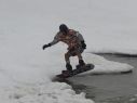
I did these two, two weeks ago. I found the road pretty rough even in my Tundra, but not anything crazy difficult. You could get to the winter TH in a sedan, but would have to go slow the last 0.25 miles, as Patrick noted. It will add 2.6mi each way and 1250ft vert total to the hike to get to and from the TH to your parking spot. Here's a screenshot with the winter TH marked by the red circle and the actual TH where my green gpx track starts/ends in the middle-left of the shot.Istoodupthere wrote: ↑Thu Oct 24, 2024 6:56 pm I came across this thread after doing a search. Can someone tell me how far a 2wd vehicle can get up the 559 rd to Medano Pass? Are there places to park near where the 4wd portion starts? Approximate round trip mileage from here to hike Mt Herard and Medano Pk? Thanks
- Boop
- MedanoPass.jpg (194.3 KiB) Viewed 12552 times
I thought, I taught, I wrought
-
Istoodupthere
- Posts: 164
- Joined: 5/5/2022
- 14ers: 47 1
- 13ers: 42 5
- Trip Reports (0)
Re: Medano Pass Rd from the East
I did these two, two weeks ago. I found the road pretty rough even in my Tundra, but not anything crazy difficult. You could get to the winter TH in a sedan, but would have to go slow the last 0.25 miles, as Patrick noted. It will add 2.6mi each way and 1250ft vert total to the hike to get to and from the TH to your parking spot. Here's a screenshot with the winter TH marked by the red circle and the actual TH where my green gpx track starts/ends in the middle-left of the shot.
MedanoPass.jpg
[/quote]
Thank you both! Very helpful
MedanoPass.jpg
[/quote]
Thank you both! Very helpful
-
greenschist
- Posts: 26
- Joined: 8/11/2020
- 14ers: 11
- 13ers: 35 1
- Trip Reports (0)
Re: Medano Pass Rd from the East
I drove this road back in August. The last few replies are correct, things get rough just before the forest boundary. A sedan could get through the rocks in this area with slow and careful driving. The biggest issue is that there is a sort of gate or cattle guard near the boundary, and a couple of inches of road was washed out on the approach. The approach is a bit steep as well. If you're in a 2WD SUV or truck, you might not have a problem unless it's gotten substantially worse since August. If you're in a sedan you're probably going to scrape. I saw a sedan parked beyond this gate when I was there, near the picnic table symbol on the FS map. They probably scraped.
-
Istoodupthere
- Posts: 164
- Joined: 5/5/2022
- 14ers: 47 1
- 13ers: 42 5
- Trip Reports (0)
Re: Medano Pass Rd from the East
Ok thanks. To be clear I’ll be driving a rental 2wd SUV. I never know what kind I’ll get. With my circumstances, is it still easier to hit these peaks from the east or would it be shorter going from the west? I’m assuming I’d need to park at Sand Dunes NP.greenschist wrote: ↑Fri Oct 25, 2024 8:31 am I drove this road back in August. The last few replies are correct, things get rough just before the forest boundary. A sedan could get through the rocks in this area with slow and careful driving. The biggest issue is that there is a sort of gate or cattle guard near the boundary, and a couple of inches of road was washed out on the approach. The approach is a bit steep as well. If you're in a 2WD SUV or truck, you might not have a problem unless it's gotten substantially worse since August. If you're in a sedan you're probably going to scrape. I saw a sedan parked beyond this gate when I was there, near the picnic table symbol on the FS map. They probably scraped.
Re: Medano Pass Rd from the East
Definitely easier from the east with a 2wd SUV than the west. Many years ago I backpacked up Medano creek from the paved Sand Dunes TH on the west side to do a 3-day trip of Herard (and camp in the dunes themselves) and it was too far for the group to manage. And too snowy, but that was mostly a separate issue. If you take the road slow, it will not be hard to get to the east side 2wd TH with ground clearance that is greater than a sedan. There were multiple BIG camper trailers parked for hunting at that area marked with the picnic table on the FS map. I wouldn't hesitate to take my Honda Civic up to that point. The road was washboarded and potholed, but nothing too difficult for a 2wd vehicle with reasonable (ie not lowered or sports car) clearanceIstoodupthere wrote: ↑Fri Oct 25, 2024 11:38 amOk thanks. To be clear I’ll be driving a rental 2wd SUV. I never know what kind I’ll get. With my circumstances, is it still easier to hit these peaks from the east or would it be shorter going from the west? I’m assuming I’d need to park at Sand Dunes NP.greenschist wrote: ↑Fri Oct 25, 2024 8:31 am I drove this road back in August. The last few replies are correct, things get rough just before the forest boundary. A sedan could get through the rocks in this area with slow and careful driving. The biggest issue is that there is a sort of gate or cattle guard near the boundary, and a couple of inches of road was washed out on the approach. The approach is a bit steep as well. If you're in a 2WD SUV or truck, you might not have a problem unless it's gotten substantially worse since August. If you're in a sedan you're probably going to scrape. I saw a sedan parked beyond this gate when I was there, near the picnic table symbol on the FS map. They probably scraped.
I thought, I taught, I wrought
-
Chicago Transplant

- Posts: 4066
- Joined: 9/7/2004
- 14ers: 58 12 24
- 13ers: 699 46 35
- Trip Reports (66)
Re: Medano Pass Rd from the East
I believe the picnic/camping area shown on the map near the east side forest boundary is roughly 2.5 miles from the trailhead while the creek crossing on the west side in the NP is more like 6, and even that may need to increase because I think the sandy lo-range section is west of the creek crossing. Long of way of saying its much shorter from the east with 2WD.
"We want the unpopular challenge. We want to test our intellect!" - Snapcase
"You are not what you own" - Fugazi
"Life's a mountain not a beach" - Fortune Cookie I got at lunch the other day
"You are not what you own" - Fugazi
"Life's a mountain not a beach" - Fortune Cookie I got at lunch the other day
-
greenschist
- Posts: 26
- Joined: 8/11/2020
- 14ers: 11
- 13ers: 35 1
- Trip Reports (0)
Re: Medano Pass Rd from the East
It's pretty much always easier to approach from the East. I wouldn't take a rental too far up the West/Dunes side unless it's a Jeep (or similar) with good tires. I've only ever driven to "Point of No Return" on that side and that's pretty early on the road, and has apparently gotten worse since I last drove it in 2021. The National Park Service maintains detailed road conditions from the Sand Dunes side on their website. The East is National Forest and lacks any such luxury, while also lacking an entrance fee. And as others have pointed out, the mileage from the Sand Dunes is much higher.Istoodupthere wrote: ↑Fri Oct 25, 2024 11:38 amOk thanks. To be clear I’ll be driving a rental 2wd SUV. I never know what kind I’ll get. With my circumstances, is it still easier to hit these peaks from the east or would it be shorter going from the west? I’m assuming I’d need to park at Sand Dunes NP.greenschist wrote: ↑Fri Oct 25, 2024 8:31 am I drove this road back in August. The last few replies are correct, things get rough just before the forest boundary. A sedan could get through the rocks in this area with slow and careful driving. The biggest issue is that there is a sort of gate or cattle guard near the boundary, and a couple of inches of road was washed out on the approach. The approach is a bit steep as well. If you're in a 2WD SUV or truck, you might not have a problem unless it's gotten substantially worse since August. If you're in a sedan you're probably going to scrape. I saw a sedan parked beyond this gate when I was there, near the picnic table symbol on the FS map. They probably scraped.

