
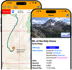


Andrew and Andrea spent around 4 hours at Medano Pass last night. This is literally the last place you'll have tree cover on the ridge until the lower northern ridgeline of Cottonwood Peak! (and then only for a second).
Getting back on the ridge from Medano is another place that seems pretty impossible with the blowdown/new growth, so you'll see their line deviates off of the ridge a little bit again, following a forest service road, then some social/deer trails, until bopping back up at a acute angle in the main ridge. This little section is what Cam and Nick scouted out which really unlocked the route. I've been meaning to see if there's a slightly more direct way, but I also need to volunteer for highway cleanup for the next few months, so what are you gunna do?
Once back on treeline, it is pretty Sound of Music up there, and a huge reprieve after the Blanca group. Miles finally start flying by. This all changes once you get to Marble Mountain, where the ridge starts tightening up again. My opinion is that Marble Mountain has the best views of the Crestones and its neighbors. Worth the trip up.
Milwaukee Peak marks when things gets serious again, but it's a bonus peak only having 297' of prominence (although someone should check that...). A little before and between Milwaukee and Marble you can pick up the Mystery Trail, which randomly starts out of nowhere and can take you towards Broken Hand Peak. I guess it drops into the basin to the south? But I've never taken all they way, opting to stay on the ridgeline, as it's just an awesome position to be in. One of those places that doesn't even feel real.
Broken Hand has some serious scrambling on it, with some towers to negotiate. Really amazing gem in the rough. Incredible relief, esp. from the north.
Andrew and Andrea have dropped pretty far down towards the Cottonwood Creek Trail -- not sure what's up with that. Maybe they're searching for water. I've been lucky I think in both of my traverses to find snow to melt nestled right in the kink of Beer Pass, north of Milwaukee Peak. The Mystery Trail does continue west, but it is much higher than where they are currently.
Andrew Hamilton & Andrea Sansone Sangres Traverse
Forum rules
- This is a mountaineering forum, so please keep your posts on-topic. Posts do not all have to be related to the 14ers but should at least be mountaineering-related.
- Personal attacks and confrontational behavior will result in removal from the forum at the discretion of the administrators.
- Do not use this forum to advertise, sell photos or other products or promote a commercial website.
- Posts will be removed at the discretion of the site administrator or moderator(s), including: Troll posts, posts pushing political views or religious beliefs, and posts with the purpose of instigating conflict within the forum.
For more details, please see the Terms of Use you agreed to when joining the forum.
-
justiner
- Posts: 4942
- Joined: 8/28/2010
- 14ers: 3 1
- Trip Reports (40)
Re: Andrew Hamilton & Andrea Sansone Sangres Traverse
Long May You Range! Purveyors of fine bespoke adventures
-
justiner
- Posts: 4942
- Joined: 8/28/2010
- 14ers: 3 1
- Trip Reports (40)
Re: Andrew Hamilton & Andrea Sansone Sangres Traverse
They've turned back to a lowpoint in the ridge. Really steep area! Hopefully they'll pick up the trail that's found just above them.
Long May You Range! Purveyors of fine bespoke adventures
-
Gulf_Coast_Hiker
- Posts: 230
- Joined: 5/29/2020
- 14ers: 25
- 13ers: 6
- Trip Reports (0)
Re: Andrew Hamilton & Andrea Sansone Sangres Traverse
So they are heading to Mt. Adams. How far along in this journey are they?
-
andreasansone

- Posts: 360
- Joined: 4/21/2014
- 14ers: 58 1 5
- 13ers: 124
- Trip Reports (1)
Re: Andrew Hamilton & Andrea Sansone Sangres Traverse
Hi you guys! We have not done any updates today and are sorry for that. This was one hell of a day! It was probably one of the craziest days Andrew and I have ever had in the mountains. Ha ha We just summited mt Adams and have about 7 1/2 miles until we get back to support so we are going through the night for now! I will have updates on Instagram tomorrow when we can recollect ourselves
“Be not afraid of going slowly, be afraid only of standing still.”
-
justiner
- Posts: 4942
- Joined: 8/28/2010
- 14ers: 3 1
- Trip Reports (40)
Re: Andrew Hamilton & Andrea Sansone Sangres Traverse
Whoo! What a push! The Obstruction to Adams part of the ridgeline is the SURPRISE! crux of the entire project. Andrew and Andrea chewed through it in four hours. It's less than 3 miles! I think that gives a good idea on the severity and quantity of the scrambling involved!
After the next peak, Fluted, the technical bits of the ridge are more or less over, and it's a long slog to the end. Fluted is also just about the halfway point as well. 27 miles to Hayden Pass that have 20 miles of travel over 12,000'.
After descending Fluted, I realized myself on my first go that I was in the throes of an asthma attack, and the rest of the trip was two steps, catch my breath, two more steps, etc. Rough!
Looks like Andrew and Andrea cruised through the night to Hermit Pass, which is accessible by 4WD, which they reached at 6:15. I see a new point at 10:15, so maybe they're on the move/on the move to make moves. LONG DAY out there! With any luck, they'll make it to Hayden Pass by the end of the day.
Camping is great at Hayden Pass. Camping after Hayden is a bivouac, which I've done a surprising number of times, now! My guess is that if they make it to Hayden today (likely), they'll have a snooze before taking on the Northern Sangres. But it's still 20+ miles from Hayden to the end -- I think they're stopping at the Rainbow TH.
After the next peak, Fluted, the technical bits of the ridge are more or less over, and it's a long slog to the end. Fluted is also just about the halfway point as well. 27 miles to Hayden Pass that have 20 miles of travel over 12,000'.
After descending Fluted, I realized myself on my first go that I was in the throes of an asthma attack, and the rest of the trip was two steps, catch my breath, two more steps, etc. Rough!
Looks like Andrew and Andrea cruised through the night to Hermit Pass, which is accessible by 4WD, which they reached at 6:15. I see a new point at 10:15, so maybe they're on the move/on the move to make moves. LONG DAY out there! With any luck, they'll make it to Hayden Pass by the end of the day.
Camping is great at Hayden Pass. Camping after Hayden is a bivouac, which I've done a surprising number of times, now! My guess is that if they make it to Hayden today (likely), they'll have a snooze before taking on the Northern Sangres. But it's still 20+ miles from Hayden to the end -- I think they're stopping at the Rainbow TH.
Long May You Range! Purveyors of fine bespoke adventures
-
justiner
- Posts: 4942
- Joined: 8/28/2010
- 14ers: 3 1
- Trip Reports (40)
Re: Andrew Hamilton & Andrea Sansone Sangres Traverse
Another late night getting through the sea of peaks after Hermit Pass. It's hard to describe seeing wave after wave of mountains in front of you knowing you have to summit all of them. With clear skies, Little Bear is still visible in back of you!
Looks like they reached Hayden Pass at 5:25 am -- yikes -- and continued about around 8:25 am to finish up the Northern Sangres.
They're currently en-route to Mt. Otto.
The Northern Sangres may be lower, but they still have teeth, with ridges of sharp talus to keep you cursing over your mis-steps. But the mountains are numbered, and soon Methodist Mountain will emerge.
Looks like they reached Hayden Pass at 5:25 am -- yikes -- and continued about around 8:25 am to finish up the Northern Sangres.
They're currently en-route to Mt. Otto.
The Northern Sangres may be lower, but they still have teeth, with ridges of sharp talus to keep you cursing over your mis-steps. But the mountains are numbered, and soon Methodist Mountain will emerge.
Last edited by justiner on Sun Jul 05, 2026 1:42 pm, edited 1 time in total.
Long May You Range! Purveyors of fine bespoke adventures
-
KentonB
- Posts: 735
- Joined: 5/13/2007
- 14ers: 58
- 13ers: 70
- Trip Reports (3)
Re: Andrew Hamilton & Andrea Sansone Sangres Traverse
Justin (or others), I'm not super-familiar with this type of endeavor. When going for the FKT, what are the criteria? I'm guessing you start/end 3,000 below the first/last summit and maybe have to tag each ranked summit along the ridge?
-
justiner
- Posts: 4942
- Joined: 8/28/2010
- 14ers: 3 1
- Trip Reports (40)
Re: Andrew Hamilton & Andrea Sansone Sangres Traverse
No, there is no 3000' rule for this -- it's more of a point to point and those points are somewhat arbitrary. I'm guessing their route is from Lake Como in the south to the Rainbow Trailhead /Methodist Mountain TH in the North, which is what Nick and Cam did. As for rules or goals of the route, I'll leave it up to Andrew and Andrea to fill in, as it's their trip.
When I've done it, my goal start/end was Lake Como Road/150 in the south to CR 107/HW50 in the north, which a bit longer. I went unsupported, as it seemed much more natural to start/end where I could get a ride to/from easily. I remember stumbling down the road from Methodist Mountain seriously, seriously dehydrated. My finish line also features a Loaf 'n Jug! and I hit the Coca Cola slushy machine HARD, which gave me the biggest brain freeze in recent human history. Going the other way, getting a hitch off of Lake Como was really difficult. Out-of-State tourists passed me and made the sign of the cross, thinking I was so hoodlum (looked the part). I was again very, very dehydrated. Finally a NPS working had pity on me, stopped, and took me to Blanca. I had 0% battery/phone/inReach/FOOD and the sun was basically set, so he was literally my last hope.
As for rules or goals, there is again no real written rules of what you're supposed to do, but my goal was every prominent peak on the ridge, and do the bonuses when it made sense. So I would offer up the list of peaks on this page that are in black:
https://justinsimoni.com/sangre-de-cris ... d-summits/
A lot of these bonus peaks are right on the ridge, and often the easiest way over is to summit them. Some are not, like Milwaukee, but it seemed fun to do it anyways. Some are juuuust off the ridge, but I thought I'd do them anyways, like Venable Peak.
I went unsupported, so all the food/gear needed from start to finish and only taking water. But I think Andrew and Andrea are going supported, meeting up with a "crew" at various points to re-up supplies and have somewhere to sleep, much like Andrew's/Andrea's 14er projects. When Nick and Cam did it, they met up with their own cache's at various points that held food/water.
When I've done it, my goal start/end was Lake Como Road/150 in the south to CR 107/HW50 in the north, which a bit longer. I went unsupported, as it seemed much more natural to start/end where I could get a ride to/from easily. I remember stumbling down the road from Methodist Mountain seriously, seriously dehydrated. My finish line also features a Loaf 'n Jug! and I hit the Coca Cola slushy machine HARD, which gave me the biggest brain freeze in recent human history. Going the other way, getting a hitch off of Lake Como was really difficult. Out-of-State tourists passed me and made the sign of the cross, thinking I was so hoodlum (looked the part). I was again very, very dehydrated. Finally a NPS working had pity on me, stopped, and took me to Blanca. I had 0% battery/phone/inReach/FOOD and the sun was basically set, so he was literally my last hope.
As for rules or goals, there is again no real written rules of what you're supposed to do, but my goal was every prominent peak on the ridge, and do the bonuses when it made sense. So I would offer up the list of peaks on this page that are in black:
https://justinsimoni.com/sangre-de-cris ... d-summits/
A lot of these bonus peaks are right on the ridge, and often the easiest way over is to summit them. Some are not, like Milwaukee, but it seemed fun to do it anyways. Some are juuuust off the ridge, but I thought I'd do them anyways, like Venable Peak.
I went unsupported, so all the food/gear needed from start to finish and only taking water. But I think Andrew and Andrea are going supported, meeting up with a "crew" at various points to re-up supplies and have somewhere to sleep, much like Andrew's/Andrea's 14er projects. When Nick and Cam did it, they met up with their own cache's at various points that held food/water.
Long May You Range! Purveyors of fine bespoke adventures
-
KentonB
- Posts: 735
- Joined: 5/13/2007
- 14ers: 58
- 13ers: 70
- Trip Reports (3)
Re: Andrew Hamilton & Andrea Sansone Sangres Traverse
Thanks! Appreciate the insight!
I remember a couple years ago or so when you did it and just couldn't even comprehend what kind of training and prep something like this must take! Truly a super-human feat!
I remember a couple years ago or so when you did it and just couldn't even comprehend what kind of training and prep something like this must take! Truly a super-human feat!
-
seannunn
- Posts: 435
- Joined: 3/6/2024
- 14ers: 54
- 13ers: 3
- Trip Reports (1)
Re: Andrew Hamilton & Andrea Sansone Sangres Traverse
I can't decide whether the drudgery of the Lake Como road would be better at the beginning of an epic adventure or at the end.
Blanca, Ellingwood, Little Bear, the lake itself; all beautiful. Hiking on that road....not so much.
Sean Nunn
Peculiar, Mo
Blanca, Ellingwood, Little Bear, the lake itself; all beautiful. Hiking on that road....not so much.
Sean Nunn
Peculiar, Mo
"Thy righteousness is like the great mountains."
--Psalm 36:6
--Psalm 36:6
-
mtnhigh358
- Posts: 137
- Joined: 7/18/2015
- 14ers: 58
- 13ers: 19
- Trip Reports (0)
Re: Andrew Hamilton & Andrea Sansone Sangres Traverse
Looks like 3 days 19 hours and 16 minutes  congrats a2! Thanks for letting us follow along! That was fun to watch. I bet you will both sleep for 24 hours straight now!
congrats a2! Thanks for letting us follow along! That was fun to watch. I bet you will both sleep for 24 hours straight now!-
14erFred
- Posts: 1100
- Joined: 7/15/2009
- 14ers: 51
- 13ers: 1
- Trip Reports (0)
Re: Andrew Hamilton & Andrea Sansone Sangres Traverse
Congratulations on completing your quest to traverse the Sangres, Andrew and Andrea! Well done! 
"Live as on a mountain." -- Marcus Aurelius