Download Agreement, Release, and Acknowledgement of Risk:
You (the person requesting this file download) fully understand mountain climbing ("Activity") involves risks and dangers of serious bodily injury, including permanent disability, paralysis, and death ("Risks") and you fully accept and assume all such risks and all responsibility for losses, costs, and damages you incur as a result of your participation in this Activity.
You acknowledge that information in the file you have chosen to download may not be accurate and may contain errors. You agree to assume all risks when using this information and agree to release and discharge 14ers.com, 14ers Inc. and the author(s) of such information (collectively, the "Released Parties").
You hereby discharge the Released Parties from all damages, actions, claims and liabilities of any nature, specifically including, but not limited to, damages, actions, claims and liabilities arising from or related to the negligence of the Released Parties. You further agree to indemnify, hold harmless and defend 14ers.com, 14ers Inc. and each of the other Released Parties from and against any loss, damage, liability and expense, including costs and attorney fees, incurred by 14ers.com, 14ers Inc. or any of the other Released Parties as a result of you using information provided on the 14ers.com or 14ers Inc. websites.
You have read this agreement, fully understand its terms and intend it to be a complete and unconditional release of all liability to the greatest extent allowed by law and agree that if any portion of this agreement is held to be invalid the balance, notwithstanding, shall continue in full force and effect.
By clicking "OK" you agree to these terms. If you DO NOT agree, click "Cancel"...
Peak: Mount Antero Route: Standard via Baldwin Gulch Distance: 15 miles Vertical: 5,200' Time: 5 hours 45 minutes round-trip including 15 mins on summit and ~10 mins of breaks / photos Ascent Party: RJansen77
I had a really tough time deciding what to do this weekend. Initial plans to make the first turns of the season at A-Basin didn't materialize, and Saturday morning I finally decided to go back and try and grab one more "dry" 14er.
On Saturday September 17th, dswink and I left the Morrison Park n Ride at 3:15am in an attempt to go get Mount Antero via Little Browns Creek. Dave had already attempted the route once, and I was fortunate to have him leading me up the seldom-traveled yet beautiful route. Unfortunately, fantastic red skies to the east at sunrise gave way to this at 13,800':
This is what Antero looked like at 13,800' on September 17th
With the talus covered by a slick layer of snow and rime, wind ripping and conditions that seemed to be worsening, we made the decision to turn around and come back when we could actually get some views. Dave wound up getting the summit soon after, but I was unable to join him in the weeks following the Fall Gathering.
After a storm dropped some big snows on the Sawatch Range, I thought that relatively dry climbs might be finished for the year, but a week of warm sunny days in Denver brought back Indian Summer, and I decided to make a one day effort via the 4wd road out of Baldwin Gulch. Having lived in Colorado for just over four months, I don't mind jeep road climbs just yet, and I was looking forward to views in the southern Sawatch.
I left Denver at 4:15 this morning, and pulled up to the start of the Baldwin Gulch 4wd road around 6:45, having dodged many a deer on the road past the Mount Princeton Hot Springs. I changed into my boots, shouldered my pack and started up a few minutes after 7am. It was a quiet, beautiful morning as I boogied up the road.
The road allows for fast hiking
Where is the elevation gain on this bad boy?
I didn't mind hiking on the road as there didn't seem to be another soul around, and the peaks above the gulch and Alpine Village looked gorgeous.
Princeton emerging...
I reached the creek crossing at 10,850' after about 45 minutes, and as the road steepened it began to feature icy patches that became more and more frequent. I had my microspikes but didn't break them out, as there were many rocks poking through making for fairly easy walking.
This was undoubtedly the crux of the climb
I continued up the road as it switchbacked above the trees, and gauged my progress by watching Cronin and trying to compare my elevation with it. The road supposedly gains 5,200' in 7.5 miles but it never felt steep.
Cronin Peak from the road - some ski possibilities?
It was pretty windy up there, I'd say gusting to 50 mph at times, but nothing that posed a problem. The snow on the road got to maybe 18 inches deep in spots but it was pretty hard packed, and you could either walk in tire tracks or on the side where dirt was showing through in order to avoid it.
Beautiful tundra with Cronin watching
Eventually I emerged above Little Browns Creek, and Shav and Tab were looking mighty fine!
Shav and Tab looking great today!
I began to recognize parts of the road Dave and I had ascended a month prior in the whiteout, and knew I must be getting close to the saddle. I was excited to get that Antero summit view that had eluded us last time!
Approaching the saddle and the top of the road
I reached the top of the road after about 2 hours and 25 minutes, and threw on a layer before hitting the ridge to the summit. The last time I was here it looked like this:
The view on September 17th...
And now it looked like this!
...and the view on October 16! Hey there summit!
I was really excited to get up there, and cruised along the ridge, arriving on the summit in just under three hours.
Classic shot of the summit ridge
The scrambling was fun after ~7 miles of jeep road.
Fun little ridge to climb along!
Summit solitude, it was beautiful up there today!
The summit
I enjoyed a Snickers bar, some water, and the phenomenal views:
The Sangres
Looking toward Pikes
Looking toward Princeton and the other Sawatch peaks
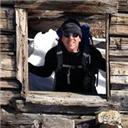
There was no one else up there to take my picture, and my camera battery didn't have enough life for a 10 second setup, so the trial and error of "awkward arm outstretched trying to take a photo of myself without looking goofy" commenced...
Possibly the worst summit self-portrait in history
After 15-20 minutes on top, I started down the ridge toward the road.
Looking down along the ridge
I began descending the road around 10:40am, and actually enjoyed it a lot. It was a long, easy stroll with gorgeous views in every direction.
The beginnings of a high alpine stroll...
It seemed as though the wind was blowing even harder on my way down, it was strong enough at points to make the whistle on my sternum strap scream. Every now and then a gust would come along that would make me lose my balance, but once the descent into Baldwin Gulch came the gusts abated substantially.
Compared with some of the other peaks I've done this summer, the routefinding here was pretty straightforward...
Not much routefinding with this one
I continuously turned around to try and get different angles of the summit:
Looking back up at the summit ridge
It was an awesome stroll back to the trees!
Cronin and company
I reached the junction about 90 minutes after leaving the summit.
Back at the junction
The walk through the trees was very pleasant, and there were still some Aspens sporting great color down low.
There are still some Aspens hanging on here.
As I reached the bottom of the road, something Boyd (fortmyers-b) once asked me came into my head. As we were finishing up KC and Challenger in August, he asked me "what do you enjoy seeing more, the summit or the car?"
What do you think? I know my answer...
Driving back toward Johnson Village, I snapped a few photos of Antero. It was a spectacular day up there.
A look back
I reached the car at 12:45pm, about 5 hours 45 minutes round trip. While the route description says this is 15 miles and 5,200' from the bottom of the road, I thought it felt more like 12 miles and 4,200'. The road never feels that steep as it switchbacks up the mountain, and I found it to be a very pleasant climb overall.
27 peaks down, 24 new ones in just over four months since moving from CT. Can't wait for the next one!
If you have any questions about this route, the condition of the road or anything else, feel free to PM me. Thanks for reading everyone!
Robert
Thumbnails for uploaded photos (click to open slideshow):
Like you I was climbing solo. It was a beautiful day despite the wind. I didn't get a dawn start as you did. No thunderstorms to worry about. I was going to ascend Roach's ”North Ridge” route, which looked great on paper. When I got a look at the ridge for real, though, I thought it had too much snow. Instead, I decided to go up a ridge just to climber's right of Roach's ”East Ridge” route. You can see the ridge clearly on your photos. It was almost bare of snow. It was really windy on the summit! On the descent, I went down the East Ridge route to its low point, then cut back to the ridge I had ascended. By the time I was back on the road, most of the ice we had encountered on the way up had melted. You might have noticed my red Jeep parked just above the stream crossing and road junction. There was another dark-colored Jeep with a Bent Gate Mountaineering sticker on the back on the other side of the road. Sorry we didn't see each other on the climb! What a great autumn day!
First, let me extend my congratulations to you on a busy and successful climbing season. I've done 15 peaks since April and I thought I was obsessed! I own a stock Subaru Forester and am wondering how high up the road you think I could get. I'm looking to park around the 11,000' level. Thanks, Mike
Thanks zdero1! It's definitely been a busy season and I'm hoping to get a few more as the snow sets in. As for the Forester, I have a 4wd '07 Honda CRV and I would not take it up there, you would likely bottom out in a Forester, and honestly you could walk faster than you could drive. Not worth it IMO as you could hike to the stream crossing (~10,850') in an hour or so without risking car damage.
Are you serious!. That's almost 3 miles an hour. I am very impressed. To date Antero was my least favorite 14er of all. Nothing worse than a hike up a long road.
Caution: The information contained in this report may not be accurate and should not be the only resource used in preparation for your climb. Failure to have the necessary experience, physical conditioning, supplies or equipment can result in injury or death. 14ers.com and the author(s) of this report provide no warranties, either express or implied, that the information provided is accurate or reliable. By using the information provided, you agree to indemnify and hold harmless 14ers.com and the report author(s) with respect to any claims and demands against them, including any attorney fees and expenses. Please read the 14ers.com Safety and Disclaimer pages for more information.
Please respect private property: 14ers.com supports the rights of private landowners to determine how and by whom their land will be used. In Colorado, it is your responsibility to determine if land is private and to obtain the appropriate permission before entering the property.


 This is what Antero looked like at 13,800' on September 17th")
 The road allows for fast hiking")
 Where is the elevation gain on this bad boy?")
 Princeton emerging...")
 This was undoubtedly the crux of the climb")
 Cronin Peak from the road - some ski possibilities?")
 Beautiful tundra with Cronin watching")
 Shav and Tab looking great today!")
 Approaching the saddle and the top of the road")
 The view on September 17th...")
 ...and the view on October 16! Hey there summit!")
 Classic shot of the summit ridge")
 Fun little ridge to climb along!")
 The summit")
 The Sangres")
 Looking toward Pikes")
 Looking toward Princeton and the other Sawatch peaks")
 Possibly the worst summit self-portrait in history")
 Looking down along the ridge")
 The beginnings of a high alpine stroll...")
 Not much routefinding with this one")
 Looking back up at the summit ridge")
 Cronin and company")
 Back at the junction")
 There are still some Aspens hanging on here.")
 What do you think? I know my answer...")
 A look back")