| Peak(s): |
Conundrum Peak - 14,037 feet |
| Date Posted: | 06/12/2013 |
| Date Climbed: | 06/09/2013 |
| Author: | Jyak |
| Peak(s): |
Conundrum Peak - 14,037 feet |
| Date Posted: | 06/12/2013 |
| Date Climbed: | 06/09/2013 |
| Author: | Jyak |
| An Alternate Line on Conundrum |
|---|
|
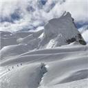
Half of the Kautz Route Rainier Team (Chris S, Chris K, and I) did an overnight trip in the basin above Montezuma Mine. We climbed an alternate set of couloirs up Conundrum, then we moved on to and traversed Castle from its northwest ridge to its northeast ridge. After a Saturday hike in and an overnight stay in Montezuma Basin, were were up at 3:30am on Sunday and out of camp at 4:30am for some good climbing on good snow; the line had some sustained angle (maybe up to 65 degrees at the top), good gain (about 1,100' vertical), and even a small section we chose to protect. If the line has a name, I don't know it. Anyone know? Finally, there was the comparatively straight forward traverse over to Castle and back down into camp.  We left on Saturday morning for the drive into Aspen, grabbed lunch, learned that Aspen posts pay-for-parking signs rather far apart (we were only "warned"), and then headed to Castle Creek Trailhead. We got across the stream crossing in Chris's Toyota Tundra, and stopped at about 10,450'. We then donned the heavy Rainier packs (just about exactly what we'll be carrying for our excursion up Kautz, for training purposes) and headed up into the basin. The hike in started around 2pm.  Late snow in May followed by the hot weather in June meant the "road" we hiked up had a good stream flowing down it in places.  At about 12,800' we stopped in the lower flats in the basin and made camp. Here is Chris S looking back at our approach route, from our camp site.  After setting camp, we began to eyeball a line up Conundrum - a rather direct one coming from our camp. The line starts just to the right of Chris K's head  Here's a look at the route from a photo taken the next day. You enter from about 12,900' and come out one small rock gendarme to climber's right of the summit.  The next photo is taken from a position at roughly the red dot in this photo just starting up the first couloir.  The entire couloir pitched to climber's right, making the left line preferable but for where thermal heating from the rock made the snow too soft. At its steepest, the bottom couloir hit about 50-55 degrees. Something about couloir climbing always makes it feel like the world just falls away from you. For the sake of Rainier training, we climbed roped up.  The next three photos are taken from the bottom of the bisecting snowfield... at the red dot.  We took a rest after exiting the first couloir and then marched across the comparatively easy climbing to the throat of the second couloir.  About that time, we got our first sun hit.  A view of Castle and a demonstration of the angle of the snowfield.  We then entered the second couloir.  The position of the red dot in this photo proved to be the crux of the route. Very passable, but we decided to protect it.  Taken from another angle (as we descended the northeast ridge of Castle, later in the day), the crux is caused by the need to traverse another cross-cutting couloir... again, at the red dot.  Being roped up came in handy as we placed two pickets on a running belay to avoid any nasty pendulum falls.  Like getting over any cornice, it got fairly steep at the end, maybe 65-70 degrees. Given how far we were kicking in steps at this point (due to softening snow), I had trouble keeping my knees out of the way.  A look back down from the top.  A look at the summit in the mid-ground... just one gendarme to bypass (we did so on climber's right).  Around 7:30am, and Chris K and Chris S are on the summit.  Me on the summit, with the next objective (Castle Peak) in the background.  A look back down into our camp. There's a tent down there, I promise.  Another look at Castle, and the green pool below the North Couloir.  After a brief stay on top, we started our decent into the saddle between Conundrum and Castle. I love shots like this, crossing the last rise (Conundrum's false summit, if you were ascending from the Castle/Conundrum saddle).  It was a straight forward climb (class 2+, maybe, and dry) up the ridge to the summit of Castle. From the summit of Castle, we got a great view of Pyramid, the Bells, and Snowmass Mountain (showing itself in the background).  Another shot to remind us how small we are and how big everything else is.  The final descent into camp; three specks (including me) in a mass of snow.  A final adventure... as we took down camp, were were continuously eye-balled by this marmot. We noticed, later, that he had chewed on the grips of both Chris S's and Chris K's trekking polls (mine were left intact as I had them fully extended and standing upright in the snow... not by design, by luck).  Then it was back through the stream/road to the car... and another lunch in Aspen (wiser about the parking this time).  Another look at our line. Kautz in 10 days. We're ready. Thumbnails for uploaded photos (click to open slideshow): ")
")
")
")
")
")
")
")
")
")
")
")
")
")
")
")
")
")
")
")
")
")
")
")
")
")
")
")
")
|
| Comments or Questions | ||||||
|---|---|---|---|---|---|---|
|
Caution: The information contained in this report may not be accurate and should not be the only resource used in preparation for your climb. Failure to have the necessary experience, physical conditioning, supplies or equipment can result in injury or death. 14ers.com and the author(s) of this report provide no warranties, either express or implied, that the information provided is accurate or reliable. By using the information provided, you agree to indemnify and hold harmless 14ers.com and the report author(s) with respect to any claims and demands against them, including any attorney fees and expenses. Please read the 14ers.com Safety and Disclaimer pages for more information.