| Report Type | Full |
| Peak(s) |
Mt. Sheridan - 13,757 feet Mt. Champion - 13,645 feet Kelso Mountain - 13,172 feet Mt. Sniktau - 13,239 feet North Star Mountain - 13,614 feet |
| Date Posted | 07/11/2017 |
| Date Climbed | 06/11/2017 |
| Author | bergsteigen |
| Additional Members | BillMiddlebrook, EatinHardtack, joelmpaula |
| 13er skiing in June: From corn to suncups (Part 1) |
|---|
While these peaks are not current, I thought the info would be good for future skiers looking for spring/summer skis of varying difficulty. For more recent beta, you can always follow me on instagram @otinaSheridanDate: June 1 Trailhead: 4 mile, where the snow started Mileage: 4.29 Elevation Gain: 2,133' Route: East face Partners: Solo I wasn't sure if the snow was freezing well or not after all the recent snows at the end of May. So I figured an easy peak, with quick access and a nice snowy east face would be a good one to get my sticks back on the snow with. I was able to drive much of the way up the road, but stopped when there was a snowbank that looked a bit too deep. When I returned I figured it could be pretty slushy. Plus there was another snow blocking the road not far afterwards, so why risk it? I ascended the lookers right snow slope just to the left of the huge ridge cornice. The new May snow was still fairly punchy on the surface as I went up, but overall not too bad. Soon I was on the summit. A few photos, and ten I was skiing back down the summit ridge and onto the skiers right snow slope. Amazingly I had pretty perfect corn at 10am! With a season of highly variable snow, this ski was pretty good, if short.      About to drop some nice corn   After that lovely half day, I talked with Joel about the ski on the next day, and was able to drive up and get some beta on an ascent route. Mt ChampionDate: June 2 Trailhead: North Lake Fork Mileage: 6 Elevation Gain: 2,861' Route: Up west face gully, east face gully descent Partners: Joel & Max After a sunny afternoon, it started to rain that evening. Not so great for the snowpack. But I was hopeful it was only a passing shower, and that it would clear for a partial freeze of the snow. I woke up to find Joel's car behind mine, and we got ready a bit slowly. We decided to hiking boot up to the stream crossing, since there was no avoiding getting our feet wet. Joel smartly brought a second pair of socks for the morning. We started from the semi avalanche destroyed trailhead and crossed the remaining hardened snow, to get to the wet trail beyond. Plenty of gushing streams to cross on the way to the main stream crossing. Some took a bit of time to find a good point without getting feet wet. But as we got to the main crossing, Joel punched through some soft snow and submerged his feet anyway. So he just walked across in his trail runners, and changed socks on the other side. I had brought sandals, so I had a bit more transitioning to do.   Once on the other side, the snow was pretty variable hardness. Some places were pretty punchy, others were solid. The gully itself has slid multiple times, and I'm guessing the debris was more solid than the surrounding snow, giving us the impression that the snow had actually frozen.  Clouds this early in the day... not a good sign    In the upper gully, the going was pretty slow, as the snow wasn't very supportive most places. I had forgotten my ax in the car, but for the most part was reasonably comfortable with just my whippet. I typically can do 35-40 degrees with just a whippet, as long as my feet feel firm. So it was only on the super firm snow that I felt a bit apprehensive. The snowy gully branched off near the top, with the left being a fearsomely steep cornice or a thinner option to the right. But since we were swimming in the snow at this point, and not making good time at all, we bailed to the south ridge which was close by at this point. From there it was a much faster scamper to the summit, even if the last few feet were post holing.    Joel approaching the corniced summit. East gully directly below Joel had been convinced that we would be skiing styrofoam. I was concerned, from the start, that the snow never froze properly, and we'd be on slush. Based on post holing the summit, slush skiing it was. The east gully was fairly punchy, but I could still make awkward jump turns. We got down to a branch on the face that pointed southerly, and more directly at the saddle we had to reach to get back to the cars. Joel decided to take that route, and I could tell by his skis, that the slush factor was high. Too high to be fun in the slightest. As he was slowly safety skiing down that route, I assessed the east gully. Not great snow, but at least I could make some regular looking turns. So I decided to drop the east gully direct, and ski around to corner to meet up with Joel. Based on the visuals of our turns, I had the slightly more fun ski. The dim lighting made photography near impossible, but the GPS don't lie.  Joel skiing on the foggy summit   Once below the peak, we decided on a high traverse over to the pass, instead of skiing more crappy vertical. The traverse was a bit spicier than I would normally do, based on snow conditions, but it was the fastest way to get out of the basin. Sometimes speed wins out.    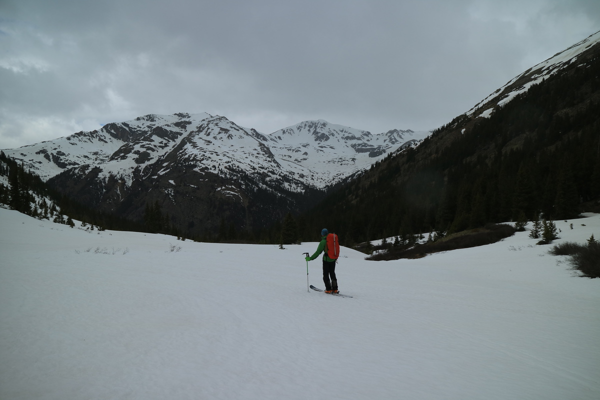 Blarney and Blue (Twining Peak) The ski down from the pass wasn't too bad. We stayed high on the skiers left side in the shadowy northern aspects, and managed to stay on snow all the way down to the trailhead. We stayed contouring high left, and managed to find an old road that almost went down to the creek crossing by the trailhead. Not a bad find in the woods, as the snow was getting patchy, but on the road it was pretty deep still. Only a few dry patches to walk. At least we made Joel's time cut off, so he could get to work. Not a great ski at all, but you can't always predict the snow freeze based on the day before, in a different range. Kelso PeakDate: June 8 Trailhead: Stevens Gulch road Mileage: 3.27 Elevation Gain: 2,416' Route: NE Gully Partners: Solo With the snow still not freezing well, I figured going with northerly aspects, I could at least get something in. Even with that, I got a stupid late start - 7am. Crossed the stream and booted up the gully. Snow started near the constriction, so at least there wasn't much talus walking today. The snow stayed reasonably firm, especially on the shady lookers left side, where I followed the previous meandering booter. I more or less followed the snow up, but and the narrow section, I went with the talus/grassy slope for a bit more speed. The higher snow was getting quite soft around 9:30, and the going got a bit slower on that final pitch up to the summit.    On the summit I was able to see what I wanted to ski the next day, Edwards. But it looked like dog shite. The lower apron looked horrific. I knew there was no motivating for that the next day. Now what? No time to think about that, as it was already pretty late in the day, and the snow was soft. So I transitioned and skied back down the gully. The upper part was pretty soft, as expected. The lower was reasonable, as the shady side was much firmer.     My turns from the road split Once back at the car, I hung out drying out my gear and having lunch. Watched lots of people hiking and running up and down the road. I drove down to the road split, and began thinking harder about what to ski the next day. That's when I came up with the NE face of Sniktau. It's a line that I've promised myself that I would ski one day, as I have seen it driving up to the tunnel some 300 times since I started ski mountaineering. If I did it as a sunrise summit, I could time the snow warming perfectly, since I knew the snow would go from rock hard to slush quickly. Plus with today's late ascent, I would know when the latest time to be ascending would be. Mt SniktauDate: June 9 Trailhead: Loveland Pass Mileage: 5 Elevation Gain: 2,942' Route: NE Face Partners: Solo I arrived well before sunrise, as the almost full moon was starting to set to the west. About an hour later I was on the ridge for sunrise. Pretty nice one today! Glad I got up early today!    Moonset Once on the ridge, the wind was howling! Hard freeze of snow this morning! I ended up putting on all my layers against the cold. Thankfully as I reached the summit, the wind subsided as I walked the couple feet down to the snow.     From here I hung out testing the snow until my ski boots made a dent in the snow. If I was just skiing down and out (versus having to reascend), I would have waited a bit longer, but I knew if I wasn't back on the summit by 9ish, the snow would be rotten. So I dropped the line around 8am. The snow was smooth and just nicely corning. the final drop to the basin below was quite nice. I could have skied down to treeline, but the snow quality rapidly dropped, and the slope was rather mellow. Maybe another time, when I set up a car shuttle. The reclimb went pretty quickly, except for the last few feet on the ridge, as the snow was losing it's support. I was down to base layers, as it was hot!   Back on the summit, I saw 3 other skiers about to drop to the north. They offered to let me ski with them, as they had set up a car shuttle. It was quite tempting, and I admit that I had though about the possibility as soon as I saw them. But they had an unknown bushwack and stream crossing below. Plus it was snow slush time, so I figured I already had the quality ski, no need for a sloppy adventure with strangers. If I had brought my sandals, I may have gone.  After the heat of the reclimb, I was back into the cold wind along the ridge, so all the clothing went back on. Pretty easy and fun turns, for only a little bit of work. Now I can drive up I-70 and say: I skied that, and smile! North Star PeakDate: June 11 Trailhead: Monte Cristo Res Mileage: 5.76 Elevation Gain: 2,305' Route: Polaris Couloir Partners: Bill & Zach After a bit and forth on which peak to do, it came down to North Star. Being north facing, we hoped the snow would be good, and with a bit of wind, nicely frozen. We started at the gate around sunrise, and made our way up and around the dam and reservoir, as a large group was on the Cristo on Quandary. We booted in regular hiking boots all the way to near the base of the couloir. The suncups were firm this morning. I never like to see the start of suncups. It means the end of skiing, even if snow remains. Since skiing on these things hurts, unless they are slushy!   After the transition and stashing of our extra gear, we started booting up to the couloir. At first it looked really promising. Then we saw it wasn't perfectly continuous at the base. A bit of an icy boulder scramble to get back into the couloir proper. Above that was a small but prominent runnel forming. The couloir was shady in the middle steep section and still hard as a rock. I measured about 47 degrees in there. As Bill and I made our way up, Zach was struggling over the scramble section. After a bit he passed it, and we though he was going to follow up the couloir. But he wasn't making much progress. Unfortunately by the time Bill or I realized he was having crampon issues, we were too far above to safely or quickly descend to help. So Zach bailed and went off to ski a slope across the way, as he watched our progress.    Photo Credit: Bill    Photo Credit: Bill  Bill and I made quick work of the remainder of the couloir, where we found the top all melted out. Bill decided to stay at the top of the snow, and I went to the summit to snap some photos (and get beta for Bill and Zach's ski the next week - where they forgot to invite me  Back at the snow, Bill helped speed the process up by building a ski platform. Since the wind had drowned out communication with Zach lower down in the couloir, we both wanted to make sure he was ok. Good thing I have lots of practice transitioning on steep slopes. The upper snowfield was nicely corned up, and the turns were fun and smooth.    Photo Credit: Bill  Photo Credit: Bill  Contemplating the steep icy section ahead Photo Credit: Bill   Steep! Once through the first steep section, it was all about runnel management. The sunny side was slushy, and we made cautious and tight jump turns. The shady side of the runnel was still icy firm, and barely edge-able. Crossing the runnel had to be done, and we tried to pick out the easiest spots.    Photo Credit: Bill  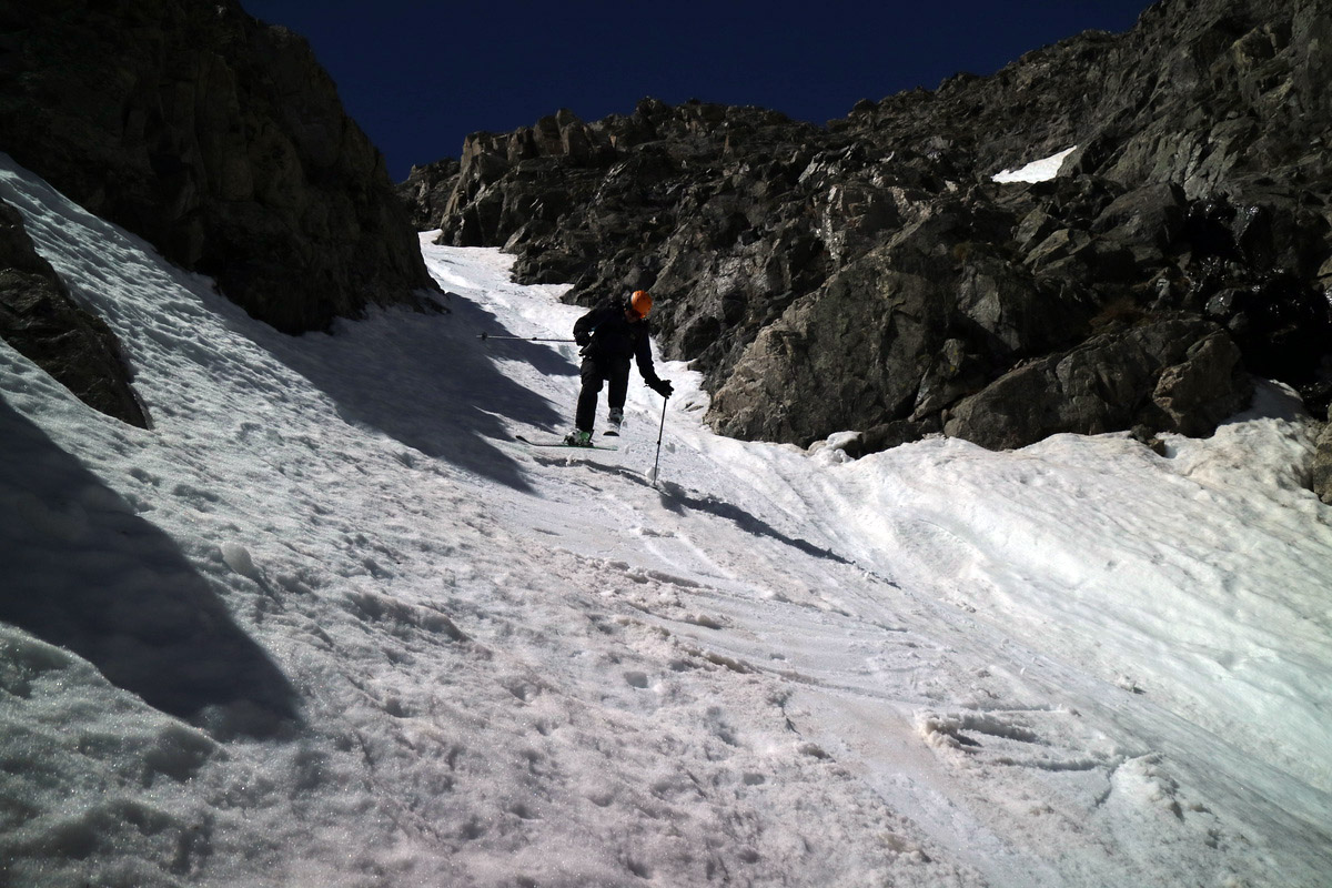   Down to the icy scramble section, Bill contemplated just trying to ski across the ice, but decided it would be safer to take the skis off and cross the boulder. I did the same, as I wouldn't want to lose an edge! Once below, it was a nice ski down to the base of the valley, where we ran into ski ninja Zach, who has watched and filmed our progress in the couloir.      Some fun skiing on the apron Photo Credit: Bill    So while these peaks were not exactly what I had planned to ski this June, at least I was on skis and got out. Part 2 of June will have more interesting lines and peaks, as no new snow fell to put a wrench in ski mountaineering! Thumbnails for uploaded photos (click to open slideshow):  Trailhead today")
 Snowy Sherman")
 Summit ridge")
 Summit pano")
 Ski down")
 Turns!")
 View from trailhead - I spy a snow ascent!")
 The western snow gully")
 Joel and Max starting up")
")
 Narro chute")
 Final snow route to summit")
 On the south ridge")
 Joel skiing down the start of the east chute")
 Joel dropping into the SE chute")
 A look back at Champion, from near the saddle")
 Casco and French")
 Lackawanna")
 Looking up the NE gully")
 View down from the center dry patch")
 Summit pano")
 About to ski the line")
 Looking back at my semi sloppy turns")
 The dirty icy gully")
 Sunrise")
 Approaching Sniktau, SE face looking cooked and done!")
 Summit pano north")
 Summit pano south")
 The line")
 My turns")
 Still some ice on the Res")
 The suncups are starting. Zach booting up")
 Bill and Zach making their way up to Polaris")
 Starting up the couloir")
 View above the scramble ice rock section")
 Zach making his way around the icy bouldering section, where his crampon bit the dust")
 Oh the icy runnel")
 Summit pano")
 Looking down the line")
 Jump!")
")
")
")
 Bill wondering if he can ski across the ice")
 Bill looking down the apron, with Quandary behind")
 Jumping the apron")
")
 A look back at the yin and yang of June couloir skiing: ice and slush")
 Zoom of Polaris")
 Haha! They didn't get to stomp on our vehicles!!")
|
| Comments or Questions |
|---|
|
|
Caution: The information contained in this report may not be accurate and should not be the only resource used in preparation for your climb. Failure to have the necessary experience, physical conditioning, supplies or equipment can result in injury or death. 14ers.com and the author(s) of this report provide no warranties, either express or implied, that the information provided is accurate or reliable. By using the information provided, you agree to indemnify and hold harmless 14ers.com and the report author(s) with respect to any claims and demands against them, including any attorney fees and expenses. Please read the 14ers.com Safety and Disclaimer pages for more information.
Please respect private property: 14ers.com supports the rights of private landowners to determine how and by whom their land will be used. In Colorado, it is your responsibility to determine if land is private and to obtain the appropriate permission before entering the property.

