Download Agreement, Release, and Acknowledgement of Risk:
You (the person requesting this file download) fully understand mountain climbing ("Activity") involves risks and dangers of serious bodily injury, including permanent disability, paralysis, and death ("Risks") and you fully accept and assume all such risks and all responsibility for losses, costs, and damages you incur as a result of your participation in this Activity.
You acknowledge that information in the file you have chosen to download may not be accurate and may contain errors. You agree to assume all risks when using this information and agree to release and discharge 14ers.com, 14ers Inc. and the author(s) of such information (collectively, the "Released Parties").
You hereby discharge the Released Parties from all damages, actions, claims and liabilities of any nature, specifically including, but not limited to, damages, actions, claims and liabilities arising from or related to the negligence of the Released Parties. You further agree to indemnify, hold harmless and defend 14ers.com, 14ers Inc. and each of the other Released Parties from and against any loss, damage, liability and expense, including costs and attorney fees, incurred by 14ers.com, 14ers Inc. or any of the other Released Parties as a result of you using information provided on the 14ers.com or 14ers Inc. websites.
You have read this agreement, fully understand its terms and intend it to be a complete and unconditional release of all liability to the greatest extent allowed by law and agree that if any portion of this agreement is held to be invalid the balance, notwithstanding, shall continue in full force and effect.
By clicking "OK" you agree to these terms. If you DO NOT agree, click "Cancel"...
This was my second attempt of Rito Alto Peak, as the last time I was here I had to turn around due to downed trees and too much ice on the 4WD road in. The weather forecast for today showed heavy winds (70-80mph) overnight that would calm down to 30mph around 8am, and a 20% chance of snow between 1-3pm. I wanted to summit 3 peaks today: Rito Alto Peak, Hermit Peak, and Eureka Mountain, and I figured if I started around 6am I should be able to summit them all and avoid the weather in the morning and the afternoon. Note: most of these pictures have been lightened because it was darker than anticipated and the pictures didn’t turn out well.
Let’s talk about Hermit Pass Road: It’s definitely a high-clearance 4WD road I wanted to drive when I wouldn’t need to pass another vehicle. October after the leaves had fallen off the trees seemed like a good time. It took me about 45 minutes to go the final 3 miles to where I parked around 11,300’. My Tundra handled it just fine, but it’s not something I want to drive again.
The wind was howling and I was seriously worried a tree would fall in the road while I was hiking and block my drive out. Note to self: time to put the axe and shovel in the back of the truck again. At one point I saw a two person backpacking tent (set up) on the side of the road. I thought to myself “Wow, they’re camping seriously close to the road. Who would do that?” (I’ve done this before near a trail, but never on a road). Then another gust of wind blew and the tent flew about 30 feet into the air and over my truck. Hmmm… seems like someone lost a tent.
I parked around 11,300’ but my truck could have made it all the way to the top of the pass. There were a lot of camping areas along the road, but not many areas to pass another vehicle.
I parked my truck and got out my gear, glad to notice it seemed the wind had stopped. My GPS stated it was 3.6 miles further on this road to the pass. I started hiking along Hermit Pass road at 6am. The stars were out in full force and there was only one small cloud in the sky, illuminated by the moon. The road was no more fun to hike than it was to drive. There are so many bowling ball sized rocks that you have to be careful where you step. At least there wasn’t any route finding involved.
I made it to Horseshoe Lake just as the sun was beginning to rise. I could see a thin layer of ice on the lake.
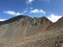
As I followed the road it curved around the hillside and up towards Hermit Pass. Here I got my first (and best) view of Rito Alto Peak. The summit was in the clouds, but I figured by the time I made it there the fog would have lifted.
Once again, well defined road to the pass
Here’s looking back on the road from the top of the pass
Just before reaching the pass I left the road and climbed a rocky gully to reach the ridge.
Once on the ridge I looked to the west and assessed the weather situation. The wind picked up and it was pushing the fog towards me at an accelerated pace. “Good” I thought. “The wind should push the fog past me around the time I make it to the summit.” Unfortunately, mountains make their own weather.
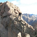
I turned northwest and headed up this rocky section
And onto the ridge
From here it was a simple class 2 ridge hike to the summit
Here is where the wind seriously started picking up, bringing the fog with it at an alarming pace. I could see it rushing up the mountainside towards me
I continued following the ridgeline as the fog turned into clouds
Now I could only see a few feet in front of me, and wondered how I’d know I’d made it to the summit?
That’s when I saw it: A flag and cairn in the distance!
I headed towards that flag and when I got there I dropped all my gear and took a photo
It was cold and that wind was brutal. I took some pictures of the memorial
And was taking a picture of the flag again when I noticed it:
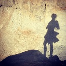
I wasn’t at the highpoint of Rito Alto Peak. The wind slowed down for a bit and I could see the terrain angled up ahead of me. Frustrated (why would the memorial be below the summit?) I gathered my gear and continued north for a couple dozen yards in almost no visibility. The rocks got larger and then I felt they were heading down. I had no idea if I’d reached the summit because I couldn’t see anything. I took a selfie (lightened for clarity) and a picture of the rocks (not lightened) and decided to head back down, hoping the clouds at this point would have cleared enough below for me to see my way to Hermit Peak.
The clouds I expected to dissipate as I hiked down instead grew thicker and I had a hard time orienting myself because I couldn’t see any landmarks. I just kept aiming southeast, hoping I was following the ridge. Every once in a while the wind would slow down and I could see a few yards ahead of me.
I was thrilled when I made it to a point where I could see the road again! It looked like this was where the clouds were at their lowest.
Foolishly I entertained the idea of waiting them out. I honestly expected the clouds to lift at any moment because weather wasn’t predicted until 1pm today (and then only a 20% chance). Instead of hiking down to the road I hiked straight to the pass, hoping to see Hermit Peak. When I got to the pass I couldn’t see Hermit Peak, or much of anything really
I did see this…
Undeterred, I decided to hike to the road slowly. Maybe the clouds would lift in the next few minutes?
I found a sign saying “road closed” and a trail register
The clouds grew thicker. Argh! I had all day to hike and I wasn’t even tired at this point. I really wanted to summit Hermit Peak and Eureka Mountain today as well, but without visuals I didn’t want to continue on. I also really didn’t want to come back for these peaks: that 4WD road in had not been pleasant and I didn’t want to drive it again. The weather was rapidly deteriorating. I wasn’t worried about summiting the 2 other peaks, I was worried about the descent from Eureka back to the lake. I’d had a good look at the route on the way in and in case the clouds didn’t lift (I still thought they would) it wasn’t a route I wanted to attempt with low visibility.
I wrestled with my decision for longer than I’d like to admit, and in the end chose to head back. This ended up being the correct choice: The clouds continued to form and followed me down the road.
The clouds played tricks with my eyes: it was if I could see each tiny particle swirling around in the mist. It was beautiful to watch but caused me to blink my eyes every so often to refocus. Visibility got a little better as I made my way back to Horseshoe Lake.
Here’s a look at the road back out
It kept getting colder and colder and then it started to snow. The snow was peaceful and nice to hike out with.
Yes, turning back had been the correct decision, but I felt a bit deflated because I didn’t get in as much elevation gain/mileage today as I’d hoped. Those clouds never lifted, they just got worse, and the snow had been quite unexpected this early in the day. I made it back to my truck at 11am, well before the possible snow time of 1pm. This was a 9 mile hike with 2849’ of elevation gain hiked in 5 hours.
I kept apologizing to my truck on the drive down: I love my truck, and this road isn’t something you do to something you love. At this sign it’s 6.7 miles up to Hermit Pass. I know I’ll be coming back to hike Hermit/Eureka, and I want to summit Rito Alto again at the same time so I can get better summit shots. Physically the hike really wasn’t very difficult from the pass. Next time I think I’ll just park here and make it a long day (or possibly come in another way?).
Here’s a look back at the weather on my way out. The snow didn’t stop for as long as I had the mountains in view.
For some reason I was under the impression the name of this peak was “Rio Alto Peak”. Maybe I just spelled it wrong in my notes the first time and never caught the error? It wasn’t until I came home and looked at my log on a topo map that I realized my mistake. Whoops!
Thumbnails for uploaded photos (click to open slideshow):
Do you use a GPS? If you'd had one with you you'd have known exactly where you were, without the need for any visual reference (except visually looking at your smartphone screen ;-)). Navigating by GPS can be done in the fog, a whiteout, on the darkest of nights, etc. Yes, yes (say the non-GPS users...), devices can fail, but (a) take care of your device and you should be fine, I've never had a complete failure, and (b) charge/change your batteries as needed before outings. And yes, have a map & compass as a backup and know how to use them (I do know how to use them, but rarely do anymore after years and years with a phone-based GPS). Just an idea.
No, I don't have a GPS. I do have a rough GPX viewer on my phone that I usually pre-load with a track if one's easily available, but the couple of times I had to use it I felt like I was cheating. It just has a blue line indicating the track on a back background, and I have it for emergencies. I like to just use a topo map and compass, and sometimes Peakbagger if needed. I have been thinking about getting a GPS however, especially as I work my way towards peaks that don't have as much information on them. I've never used a GPS before and don't even know what to look for
I took another flag off of Rito Alto last year. Apparently someone keeps replacing it.
It's really not the proper place for a flag and if you see it please take it down and give it to the VFW or similar organization for proper retirement.
It seems like Hermit Pass is just a windy place. When I headed up there to do Rito Alto and friends in May 2012, I barely crawled to Hermit Peak, then called it a day. Fortunately there wasn't any fog, but the wind was transporting enough smoke from wildfires in southwest New Mexico to make the whole place smell like a barbecue. This was my sunrise:
GoogleMaps on my phone said it was 3.6 miles further on this road to the pass As soon as I got out of my truck it showed I'd "parked" and saved my parking spot and turned off.
If you don't have a GPS please don't buy a dedicated GPS unit, they're becoming dinosaurs and are pretty expensive. Two ideas:
-You can just get an app for your smartphone. Gaia is one, Backcountry Navigator is the other. I've used both and find Gaia the easiest to use, just seems more intuitive to me. My pet peeve is that the "you are here" arrow cannot be enlarged, although you can change the color of it. Unless I have my reading glasses out it's sometimes hard to see, esp in bright sunlight. I've asked them to change that, but I get the "if enough people ask" retort, annoying. But hey, it works really well even with that annoying quirk.
-Do you have a beacon, eg Garmin Inreach? If so, the Garmin can be paired with your phone (much bigger screen) and their GPS app is super simple, a big "you are here" arrow, etc. It's what I use.
I get it, the whole old school resistance by some to GPS, but once you learn a simple app it's a total game changer. Night navigation, whiteouts, etc. Most of what I do lately is remote off trail stuff, and when paired with at-home satellite links, it is a huge help, e.g. finding a way down a remote canyon in the high desert to a specific traversing ledge. I totaly get the "not all who wander are lost" idea, but if you're like me, your free time hours/days are limited, I don't have a ton of free time to wander. GPS really helps. Just an idea.
Thanks for the report and the parking advice. Hiked up there today (7/13/21) and parked where you recommended. For others considering this route, the road is relentlessly rocky, easily passable with pickup or 4runner, but maybe not worth the effort. You might get a concussion from bouncing around over all the rocks. From the sign, my GPS recorded 7.5 miles to the pass, and 8.4 miles to the summit.
Caution: The information contained in this report may not be accurate and should not be the only resource used in preparation for your climb. Failure to have the necessary experience, physical conditioning, supplies or equipment can result in injury or death. 14ers.com and the author(s) of this report provide no warranties, either express or implied, that the information provided is accurate or reliable. By using the information provided, you agree to indemnify and hold harmless 14ers.com and the report author(s) with respect to any claims and demands against them, including any attorney fees and expenses. Please read the 14ers.com Safety and Disclaimer pages for more information.
Please respect private property: 14ers.com supports the rights of private landowners to determine how and by whom their land will be used. In Colorado, it is your responsibility to determine if land is private and to obtain the appropriate permission before entering the property.