


I completely get that Bill. Makes tons of sense. I jumped the emotional gun while thinking of possibilities related to extreme fire. Thanks for responding and for putting up the alerts and notifications you have. Really, thanks for what you think about and do behind the scenes.BillMiddlebrook wrote: ↑Mon Jun 29, 2026 3:28 pm While I have thought of adding a wildfire overlay in the map, I'm not sure how much it would be used since people use Watch Duty, Facebook, COTrex, and other apps. However, whenever there are incidents like this, I do try to get "Alerts" out on 14er, Trailhead, or Route pages. Since the route descriptions are used more than anything else on the site, people should see those alerts. AND, they immediately get picked up by the mobile apps so they can't miss them when viewing impacted routes. Like, now, if you look at the Massive route, you'll see alerts. I can change them on the fly and provide more info than just a wildfire polygon.
I learned a while back that recreating what other sites have, is mostly a waste of time and effort. Like when I built a full map "Drawing" interface that was much easier to use than CalTopo, providing a simple way to create map tracks/waypoints and download them to GPX or KML. But hardly anyone would use it, so I canned it. Oh well. I'm guessing CalTopo will continue to offer some free tools, like basic map drawing.
FIRES
Forum rules
- This is a mountaineering forum, so please keep your posts on-topic. Posts do not all have to be related to the 14ers but should at least be mountaineering-related.
- Personal attacks and confrontational behavior will result in removal from the forum at the discretion of the administrators.
- Do not use this forum to advertise, sell photos or other products or promote a commercial website.
- Posts will be removed at the discretion of the site administrator or moderator(s), including: Troll posts, posts pushing political views or religious beliefs, and posts with the purpose of instigating conflict within the forum.
-
greenonion
- Posts: 2169
- Joined: 10/3/2012
- 14ers: 52 1
- 13ers: 2
- Trip Reports (0)
Re: FIRES
-
Androzs

- Posts: 5
- Joined: 7/24/2023
- 13ers: 5
- Trip Reports (0)
Re: FIRES
I wanna climb Kit Carson soon. I live in Gunnison. Wondering what the smoke is like up at Willow Lake from anyone that's been recently. Looks like it shouldn't be bad.
-
Arthur Shagisultanov
- Posts: 3
- Joined: 11/13/2024
- Trip Reports (0)
Re: FIRES
We climbed Crestone Peak yesterday. There was a moderate, low-hanging haze in the San Luis Valley starting late morning, but the Sangres were completely clear. The smoke is quite variable, though—we climbed Crestone Needle a week ago, and it was so bad on the drive out that the sun disappeared entirely behind the smoke well before sunset.
Here's a great resource for tracking fires, smoke, and air quality: https://fire.airnow.gov/. The AQI monitor in Crestone looks to be good right now.
-
ECF55

- Posts: 210
- Joined: 8/26/2017
- 14ers: 14
- 13ers: 4
- Trip Reports (9)
Re: FIRES
For sure. I'm heading out in a week and have been angsting a lot about the conditions. Monsoon moisture pulses clearly put the explosive fire growth in check. Big dry heat domes tend to make things much more combustable and then it comes down to wind direction for where the smoke is carried. Some of those AQIs last week looked really unpleasant.
Here's to a surge of monsoon moisture. Good luck out there.
-
bdloftin77

- Posts: 1395
- Joined: 9/23/2013
- 14ers: 58 1
- 13ers: 99
- Trip Reports (2)
Re: FIRES
Gold Mtn Fire jumped into the West Fork area.  One of my favorite parts of Colorado.
https://inciweb.wildfire.gov/incident-i ... ntain-fire
 One of my favorite parts of Colorado.
https://inciweb.wildfire.gov/incident-i ... ntain-fire
-
SkaredShtles

- Posts: 2576
- Joined: 5/20/2013
- Trip Reports (0)
Re: FIRES
Looks like it may have leapfrogged the Middle Fork as well...bdloftin77 wrote: ↑Sun Jul 12, 2026 9:54 am Gold Mtn Fire jumped into the West Fork area.
https://inciweb.wildfire.gov/incident-i ... ntain-fire
You do not have the required permissions to view the files attached to this post.
-
bdloftin77
- Posts: 1395
- Joined: 9/23/2013
- 14ers: 58 1
- 13ers: 99
- Trip Reports (2)
Re: FIRES
Indeed it did. Wonder if that whole area will go up in flames.
You do not have the required permissions to view the files attached to this post.
-
dwoodward13
- Posts: 915
- Joined: 3/26/2011
- 14ers: 58 12
- 13ers: 181 6
- Trip Reports (1)
Re: FIRES
Sad news that a pilot of a firefighting helicopter was killed after crashing in Silver Jack Reservoir.
https://coloradosun.com/2026/07/13/pilo ... ire-crash/
https://coloradosun.com/2026/07/13/pilo ... ire-crash/
-
chicken_dip

- Posts: 1
- Joined: 6/28/2026
- 13ers: 1
- Trip Reports (0)
Re: FIRES
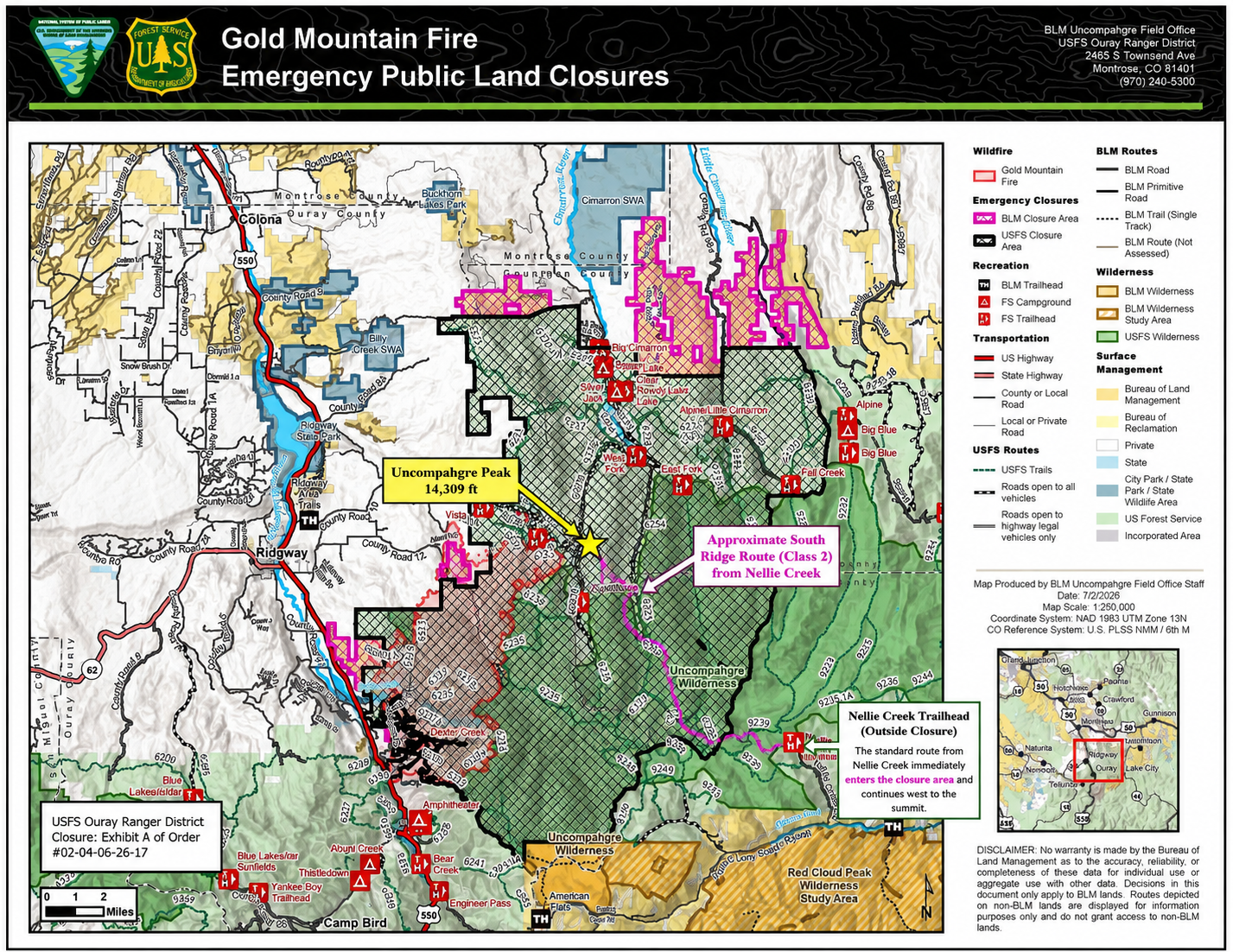
Hi all, i have read a ton of conflicting information as to whether or not Uncompahgre is climbable right now. The Gold Creek Fire page doesn't list Nellie Creek as one of the TH closures but I just wanted to be sure since everything else is saying it is closed. I live in Gunnison so it wouldn't be trek to come back to town but I have 4 days planned already this week.
EDIT: Updated closure map just came out. I am going to go ahead and say the trail closed for sure.
https://inciweb-prod-media-bucket.s3.us ... zKIf4jeil3
EDIT: Updated closure map just came out. I am going to go ahead and say the trail closed for sure.
https://inciweb-prod-media-bucket.s3.us ... zKIf4jeil3
-
greenonion
- Posts: 2169
- Joined: 10/3/2012
- 14ers: 52 1
- 13ers: 2
- Trip Reports (0)
Re: FIRES
Agreed. According to that map, the actual TH is outside the closure, but not by far. And most of the trail itself is in the closure. Best to stay away for nowchicken_dip wrote: ↑Mon Jul 13, 2026 4:24 pm Hi all, i have read a ton of conflicting information as to whether or not Uncompahgre is climbable right now. The Gold Creek Fire page doesn't list Nellie Creek as one of the TH closures but I just wanted to be sure since everything else is saying it is closed. I live in Gunnison so it wouldn't be trek to come back to town but I have 4 days planned already this week.
EDIT: Updated closure map just came out. I am going to go ahead and say the trail closed for sure.
https://inciweb-prod-media-bucket.s3.us ... zKIf4jeil3
-
dwoodward13
- Posts: 915
- Joined: 3/26/2011
- 14ers: 58 12
- 13ers: 181 6
- Trip Reports (1)
Re: FIRES
To add to the confusion, that location for the summit is rather hilariously wrong. Not the highest quality map, but on the amended 7/2 closure order (latest on the GUMG website) the summit is right on the closure boundary (the closure line follows the Ouray/Gunnison Ranger District boundaries, which bisects the summit), but per the letter of the law the summit trail does jussstt cross into the closure on the ridge. I'd also consider with the new Elk Fire, air quality is going to be highly suspect with a wind direction out of the N, NE, or NW between the two fires.chicken_dip wrote: ↑Mon Jul 13, 2026 4:24 pm Hi all, i have read a ton of conflicting information as to whether or not Uncompahgre is climbable right now. The Gold Creek Fire page doesn't list Nellie Creek as one of the TH closures but I just wanted to be sure since everything else is saying it is closed. I live in Gunnison so it wouldn't be trek to come back to town but I have 4 days planned already this week.
EDIT: Updated closure map just came out. I am going to go ahead and say the trail closed for sure.
https://inciweb-prod-media-bucket.s3.us ... zKIf4jeil3