


I have to say - I really do like this 3D map feature of the chatGPT astra that came out over labor day.
Right away i was able to drill into these real world terrain maps around red rocks, mt morrison and surrounding peaks.
But then i got to thinking - why not do the same for hyper localized maps of routes for our peaks for reals? like maybe especially the dangerous ones like capital, longs etc.
keep in mind you are entering my personal mindspace so buckle up. these here are actually particular to my own aesthetic system. the larger point being using this for route mapping. it can really drill down - you could pair a route map with photos of specific sections linked in hyperlinks (something I haven't done yet but is allegedly a thing it could do)
Huge David Robert Mitchell fan.
__
But this is the more landscape thing I did that is pretty cool. music by phish 12/31/24
Should we start doing 3D real world maps of all 14,000 routes of all peaks?
Forum rules
- This is a mountaineering forum, so please keep your posts on-topic. Posts do not all have to be related to the 14ers but should at least be mountaineering-related.
- Personal attacks and confrontational behavior will result in removal from the forum at the discretion of the administrators.
- Do not use this forum to advertise, sell photos or other products or promote a commercial website.
- Posts will be removed at the discretion of the site administrator or moderator(s), including: Troll posts, posts pushing political views or religious beliefs, and posts with the purpose of instigating conflict within the forum.
-
jibler

- Posts: 771
- Joined: 6/12/2008
- 14ers: 13
- 13ers: 41
- Trip Reports (21)
Should we start doing 3D real world maps of all 14,000 routes of all peaks?
Keep looking up - Jack Horkheimer
-
justiner
- Posts: 4942
- Joined: 8/28/2010
- 14ers: 3 1
- Trip Reports (40)
Re: Should we start doing 3D real world maps of all 14,000 routes of all peaks?
Augmented reality apps that will tell you exactly where to place your feet are coming, just like augmented reality apps that tell you exactly where climbing routes are, where the holds are, how to use them, what/where gear to place are coming.
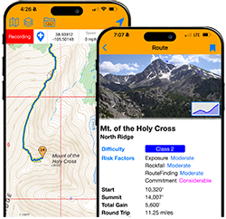
If you want now, Caltopo has a 3D viewer, which you can use to follow a track, and do that all in real time and all from your phone. Caltopo supports adding markers w/images.
If you want now, Caltopo has a 3D viewer, which you can use to follow a track, and do that all in real time and all from your phone. Caltopo supports adding markers w/images.
Long May You Range! Purveyors of fine bespoke adventures
-
Dave B

- Posts: 2488
- Joined: 6/14/2010
- Trip Reports (9)
Re: Should we start doing 3D real world maps of all 14,000 routes of all peaks?
Did SkyNet write this post?
As pointed out by Vuori, I'm a curmudgeon and, as such, think less information needs to be out there on the 14ers, not more. So no, we don't need 3d real world maps.
Anyways, a .gpx file can be imported into google earth and explored with a flyby similar to the ChatGizzle video. Just not with the bitchin' music.
As pointed out by Vuori, I'm a curmudgeon and, as such, think less information needs to be out there on the 14ers, not more. So no, we don't need 3d real world maps.
Anyways, a .gpx file can be imported into google earth and explored with a flyby similar to the ChatGizzle video. Just not with the bitchin' music.