


Staying on the Trails
Forum rules
- This is a mountaineering forum, so please keep your posts on-topic. Posts do not all have to be related to the 14ers but should at least be mountaineering-related.
- Personal attacks and confrontational behavior will result in removal from the forum at the discretion of the administrators.
- Do not use this forum to advertise, sell photos or other products or promote a commercial website.
- Posts will be removed at the discretion of the site administrator or moderator(s), including: Troll posts, posts pushing political views or religious beliefs, and posts with the purpose of instigating conflict within the forum.
-
DonFMeyers
- Posts: 1
- Joined: 12/16/2025
- Trip Reports (0)
Staying on the Trails
Howdy Folks, I'm new to this page and really appreciate the Honest and Helpful infomation given here. I asked a while back about electronics that are used to keep you on established trails. Garmin inReach Mini 2 was mentioned several times. All Trails had mixed reviews. Then I ran into the OnX Backcountry App. They claim that the app can be loaded onto your phone and that a Garmin style hiking tool isn't needed. I'm interested what the 14'r community has to say about using OnX Backcountry instead of a Garmin or add it too assist in route finding. TIA
-
hellmanm

- Posts: 382
- Joined: 8/5/2014
- 14ers: 58
- 13ers: 75 1
- Trip Reports (9)
Re: Staying on the Trails
Well, if you want an app, Gaia is a great choice. I download gpx files from this site and load them into Gaia (which, btw, is free) all the time.
With that said, you shouldn’t be relying on any app to keep you on the trail. Learning to use landmarks+cairns, following logical paths…etc are valuable skills, and you don’t want to be screwed if your phone dies. Some 13ers don’t even have good trails to follow, and in my pre-pandemic hiking days I used to print out pictures of each route for reference and keep them in a ziploc bag to keep them dry. Admittedly, I’ve gotten a bit lazy, but no app is 100% reliable and it feels good to be self-reliant.
AllTrails in particular is terrible, as it’s information is dangerously unreliable and the trip reports tend to be lower-quality. If you had to go with one of your listed choices, go with Garmin — if you already have an inreach mini, you might as well make use of its features. Btw the purpose of an inreach isn’t to keep you on-route; it’s to be able to call for help if you or someone else needs rescue. You’re not paying hundreds of dollars for directions… you’re paying for the emergency features.
With that said, you shouldn’t be relying on any app to keep you on the trail. Learning to use landmarks+cairns, following logical paths…etc are valuable skills, and you don’t want to be screwed if your phone dies. Some 13ers don’t even have good trails to follow, and in my pre-pandemic hiking days I used to print out pictures of each route for reference and keep them in a ziploc bag to keep them dry. Admittedly, I’ve gotten a bit lazy, but no app is 100% reliable and it feels good to be self-reliant.
AllTrails in particular is terrible, as it’s information is dangerously unreliable and the trip reports tend to be lower-quality. If you had to go with one of your listed choices, go with Garmin — if you already have an inreach mini, you might as well make use of its features. Btw the purpose of an inreach isn’t to keep you on-route; it’s to be able to call for help if you or someone else needs rescue. You’re not paying hundreds of dollars for directions… you’re paying for the emergency features.
-
John619
- Posts: 56
- Joined: 3/2/2019
- 14ers: 21 7
- 13ers: 1
- Trip Reports (0)
Re: Staying on the Trails
I use a Garmin InReach Mini with the Earthmate app as well as Galia and CalTopo. That said I always have a paper map, compass and altimeter (I'm an old guy who has been using those for 50+ years).
-
BillMiddlebrook

- Site Administrator
- Posts: 6779
- Joined: 7/25/2004
- 14ers: 58 47 19
- 13ers: 174 45 37
- Trip Reports (5)
Re: Staying on the Trails
14er trails?
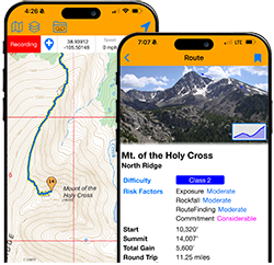
The 14ers.com app. It's Free and includes the full .com route descriptions, and full tracking and waypoint recording.
The 14ers.com app. It's Free and includes the full .com route descriptions, and full tracking and waypoint recording.
Fascism, xenophobia, racism, and ignorance are not inevitable—they are choices. And so are compassion, understanding, and justice. Educate yourself and choose better.
-
dwoodward13
- Posts: 934
- Joined: 3/26/2011
- 14ers: 58 12
- 13ers: 194 6
- Trip Reports (1)
Re: Staying on the Trails
I'm a bit surprised you would get inreach mini 2 recommendations for navigation. That doesn't make a lot of sense to me unless I'm missing something. The on device navigation is just a line on a b&w screen, ie no on device topo maps or trails. And while you can tether it to your phone and use their app, that kind of defeats the purpose of treating it as a standalone device. I do agree with a previous poster that it is valuable for SOS/communication but the nav side is more of a backup option if you want something fully featured.
Probably the 3 biggest/most popular/best phone navigation apps are Caltopo, OnX, and Gaia (AllTrails is also popular but commonly known as AllFails). I don't think you can really go wrong with either of them, although Gaia did get bought out by a PE firm a little bit ago and some people have been having a lot more issues. They all have various price points that come with different levels of features. I've been using Gaia for nearly 10 years now, mostly because I get a free premium subscription for some volunteer work I do. Prior to that I used Avenza which has a bigger learning curve than the other 3, but is free if you are willing to put the work into making your own georeferenced PDFs. 14ers app is also great for saving the route descriptions/photos of the 14ers, but if you are doing more other stuff might not be as valuable.
All these phone apps always come with the caveat that your phone can/will die, get dropped and break a screen, get lost, ect. So you should always be prepared for that. This is where the inreach nav could actually be beneficial, or go old school and bring paper maps. I've spent many an afternoon tentbound by a storm staring at every detail of the NatGeo topos! If you are sticking to the popular 14ers/trails in the state you really only need navigation as a check in occasionally vs staring at it the whole time (or a how much longer do I have?). Popular routes are generally very well signed and traveled.
Probably the 3 biggest/most popular/best phone navigation apps are Caltopo, OnX, and Gaia (AllTrails is also popular but commonly known as AllFails). I don't think you can really go wrong with either of them, although Gaia did get bought out by a PE firm a little bit ago and some people have been having a lot more issues. They all have various price points that come with different levels of features. I've been using Gaia for nearly 10 years now, mostly because I get a free premium subscription for some volunteer work I do. Prior to that I used Avenza which has a bigger learning curve than the other 3, but is free if you are willing to put the work into making your own georeferenced PDFs. 14ers app is also great for saving the route descriptions/photos of the 14ers, but if you are doing more other stuff might not be as valuable.
All these phone apps always come with the caveat that your phone can/will die, get dropped and break a screen, get lost, ect. So you should always be prepared for that. This is where the inreach nav could actually be beneficial, or go old school and bring paper maps. I've spent many an afternoon tentbound by a storm staring at every detail of the NatGeo topos! If you are sticking to the popular 14ers/trails in the state you really only need navigation as a check in occasionally vs staring at it the whole time (or a how much longer do I have?). Popular routes are generally very well signed and traveled.
-
justiner

- Posts: 4943
- Joined: 8/28/2010
- 14ers: 3 1
- Trip Reports (40)
Re: Staying on the Trails
inreach mini 2 would be an odd choice for navigation, but a great choice for casual sat comm and excellent choice for emergency comm. The NEW inreach mini 3 does have a new display w/mapping feature if you wanna use the tiiiiiiny display to navigate (but people use their watches, so maybe this will work for some).
Phone apps are the way to go. I'm a huge Caltopo fanboy, tho there is a learning curve. But if there is a trail out there in CO, it's usually on the app. The key is to download the map layers to use offline (which again is several steps to learn). They cater to SAR outfits, if that's any indication if it's good for emergency situations...
Gaia I think is suffering under OutsideOnline, as many of the features people thought great are being removed from the free version?
AllTrails same thing - they literally had to offer an apology/rollback this year for their last money grab. And the QA for community-added routes are atrocious.
People do worry about losing/damaging your phone -- or it running out of battery. Losing... I dunno, a case with a tether? Could help with damaging as well, but getting the phone drenched is probably more an issue -- solved with a ziplock bag. Small, lightweight, inexpensive power banks exist that can extend phone run time by days.
Phone apps are the way to go. I'm a huge Caltopo fanboy, tho there is a learning curve. But if there is a trail out there in CO, it's usually on the app. The key is to download the map layers to use offline (which again is several steps to learn). They cater to SAR outfits, if that's any indication if it's good for emergency situations...
Gaia I think is suffering under OutsideOnline, as many of the features people thought great are being removed from the free version?
AllTrails same thing - they literally had to offer an apology/rollback this year for their last money grab. And the QA for community-added routes are atrocious.
People do worry about losing/damaging your phone -- or it running out of battery. Losing... I dunno, a case with a tether? Could help with damaging as well, but getting the phone drenched is probably more an issue -- solved with a ziplock bag. Small, lightweight, inexpensive power banks exist that can extend phone run time by days.
Long May You Range! Purveyors of fine bespoke adventures

Re: Staying on the Trails
Like others have said, an app shouldn't be necessary to stay on a trail. Learn how to navigate without a app, it's probably the most useful skill a hiker has. Use that brain, it's powerful for a reason. Besides, do you want to see the splendor of nature or have your eyes glued to your phone for the entire hike?
For those times when an app is useful, assuming you're climbing peaks (this is a peak website, after all), I suggest Peakbagger. Shocking suggestion, I know.
For those times when an app is useful, assuming you're climbing peaks (this is a peak website, after all), I suggest Peakbagger. Shocking suggestion, I know.
supranihilest wrote: ↑Fri Feb 24, 2023 8:50 am Let's see how deep I can quote myself over the years.
Third mention of it being free just for fun. And another mention of it doing everything all the other apps do. While still being free. Did I mention that it's free? And that it finds peaks for you? Free peak finding is pretty cool.supranihilest wrote: ↑Mon Aug 23, 2021 9:58 pm Copied from another post asking a similar question:
Again - free, offline maps and GPX imports. The rest is just icing on the cake.supranihilest wrote: ↑Fri May 14, 2021 9:38 am For peak bagging I use... Drumroll please... Peakbagger. Yep.
- Free
- Offline topo map downloads
- Daily low-res and weekly high-res satellite photos
- Find peak waypoints easily and save them offline
- Trip reports and GPX tracks easily downloadable (if one is available for a particular peak)
- Peaks available worldwide, not just in US
- Syncs to Lists of John for LoJers
Spanish Peaks overview with tracks I downloaded right from the app. I can also download GPX from LoJ/All Trails/Hiking Project/anywhere that has GPX tracks and import them to Peakbagger.
West Spanish Peak overview.
West Spanish Peak GPX closeup for fine detail.
Want to know where you are on a track, or where a spot on a track is? You can find that out.
Track details.
Selection of peaks and tracks I've saved offline.
High-level overview of Boulder and Jefferson counties with dozens of tracks I've saved.
I don't trust an app on my phone not to kill the battery, plus what happens if I drop my phone on a rock and destroy the thing, so I also use a GPS watch (Garmin Fenix 5 edit: Fenix 7 as of 2023) for ~20-24 hour battery life and breadcrumb trail, and a Garmin inReach for connectivity to the outside world (friends and family can watch live on an online map) and texting, plus multi-day battery life. Never had to use the SOS on my inReach but it's available if need be.
If you're only going to get one, single device I'd recommend an inReach since it has damn near every feature you could want, but the drawback is that it's not cheap.


-
DaveLanders
- Posts: 587
- Joined: 3/7/2009
- Trip Reports (0)
Re: Staying on the Trails
I would be hesitant to rely on an app for navigation. It will only be as accurate as the source the app used for the trail location. The USGS maps have lots of errors either because of trail reroutes, or because the map was never correct in the first place. The 14ers.com app is probably an exception because Bill has personally checked the routes.
Every village has at least one idiot. Successful villages choose someone else to be their leader.
-
Marmot72

- Posts: 483
- Joined: 9/2/2007
- 14ers: 58 2
- 13ers: 649 17
- Trip Reports (46)
Re: Staying on the Trails
I have used the OnX Backcountry app for this year and 2024 and find it very helpful. The problem with USGS data is it's famously outdated: trails from 1960 are either long-gone or rerouted. OnX pulls in data from contemporary sources, including routes on Mountain Project. As others have said, no app is a replacement for orientation and route-finding skills (which are honed through practice) but I have found OnX to be pretty helpful of plan days in the wilderness, and to verify a bushwhack/off trail return to the trail, since many summits still do not have established trails all the way.
Another good thing about OnX is that it identifies private property.
-Steve
Another good thing about OnX is that it identifies private property.
-Steve
I have phenomenal route-finding abilities. Specifically, I have an uncanny knack for selecting the path of most resistance.
-
justiner
- Posts: 4943
- Joined: 8/28/2010
- 14ers: 3 1
- Trip Reports (40)
Re: Staying on the Trails
I believe Caltopo uses OpenStreetMap for trails, and that's the information that's shown, regardless of the default overlay map. There is a process in OpenStreetMap for adding your own trails to the database I believe, although I have never done it.
Caltopo does have a map layers for public property and private property.
If you shell out the big bucks, the live satellite stuff is pretty useful, especially for planning in the early summer.
Caltopo does have a map layers for public property and private property.
If you shell out the big bucks, the live satellite stuff is pretty useful, especially for planning in the early summer.
Long May You Range! Purveyors of fine bespoke adventures
-
astranko
- Posts: 167
- Joined: 7/27/2020
- 14ers: 46 20
- 13ers: 270 8
- Trip Reports (4)
Re: Staying on the Trails
Updating OSM is easy and fun!justiner wrote: ↑Tue Dec 30, 2025 6:19 pm I believe Caltopo uses OpenStreetMap for trails, and that's the information that's shown, regardless of the default overlay map. There is a process in OpenStreetMap for adding your own trails to the database I believe, although I have never done it.
Caltopo does have a map layers for public property and private property.
If you shell out the big bucks, the live satellite stuff is pretty useful, especially for planning in the early summer.
If you have a GPX/track of an otherwise poorly recorded trail, adding it onto OSM is a good way to give back to the hiking community. The quality of the data is a reflection of the community that is producing it. If you want Alltrails/Caltopo/OnX to be accurate, then we need to contribute.
It has a wiki ethic, so when in doubt, send a PM before you start editing things. I follow the rule of thumb of "only edit that which you have complete, high quality data for".
Save Yahoo Mountain
Re: Staying on the Trails
Like everyone says, the InReach Mini is better suited to communication (emergency or otherwise) than to navigation. It is an excellent emergency communication tool, though.
I keep the CalTopo map on my phone, and carry a paper map and compass as backup. Sometimes I print a map off of CalTopo, other times I buy a map. I use a handheld Garmin with lithium AA batteries in winter because phone batteries don't last long in the cold. Paper maps are more than just a backup for when your phone fails; they give a much bigger picture of the area than any phone I would want to carry.
I keep the CalTopo map on my phone, and carry a paper map and compass as backup. Sometimes I print a map off of CalTopo, other times I buy a map. I use a handheld Garmin with lithium AA batteries in winter because phone batteries don't last long in the cold. Paper maps are more than just a backup for when your phone fails; they give a much bigger picture of the area than any phone I would want to carry.
mark