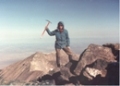


The peak is ~2750 ft high, on Gordon Island, and marks the entrance to the Romanche Fjord to its east. (The Romanche Fjord entrance is directly south of the mouth of the Romanche Glacier in the Darwin Range on the Isla Grande de Tierra del Fuego, just on the opposite side of the Northwest arm of the Beagle Channel). Our boat was moored via land lines on the north coast of Caleta Morning, just east of a waterfall, and the local dolphins gave us a show every day. (I think we provided some excitement for them; the only other boat we saw during our three days west of Ushuaia was a Chilean Antarctic research vessel). The first reported ascent was done by 14ers.com members BrettN25 (Brett Nichols) and myself (Ulli Bayer), led by Seba Beltrame (of Patagon Mountain Agency), on Mon Feb 23 2026. Our expedition additionally included Andrew and Jackie Thorburn (who had organized the trip) and captain Roberto (of the 46 ft ketch “Xanadu” of Puerto Williams). The first crux of the climb came early: a ravine in the woods not even half-way around the north shore of the lake immediately above Caleta Morning. With careful route finding, the downclimb was kept at class 2. However, the ascent on the other side seemed like 3rd class moss, with a 4th class crux, for which one team member used their ice axe to good effect. Several other notches appeared on the ridge before tree line, making my heart sink each time, but none of these posed any difficulty. When we reached the steep rocky part of the ridge, we were in the fog and had to decide to go right or left. We went right, in hopes to find an easy gully that would circumvent a big gendarme/sub-summit (and because the ascent on the left had earlier looked from the distance like potential class 4/5 on rotten rock). The right side involved a traverse on steep terrain, first on small boulders, then through various other loose stuff, delivering us to a steep rock gully with running water. There, we roped up, and one pitch of class 4/5.easy went partway up this gully, with an exit traverse to the left. Then class 2/3 rock and snow up to the ridge, beyond the first gendarme/sub-summit. Fortunately, the snow was just perfect (as we had stashed our crampons and ice axes earlier). Then just 70 ft of a little more difficult class 3 to the summit! Well, just that there was a higher summit right behind it; and then one more. This summit ridge was pretty exposed, on easy class 3, but with now pretty slippery rock. On the descent, we decided to check out the left side instead. The fog lifted on the saddle below the gendarme, and we finally got a good look at our route. And we were happy to find that the way that we had decided against on the way up now offered an easy class 2/3 descent (joking that this will now be the “standard route” that will not be climbed again in 50 years). For a name of the peak, we’ll submit “Monte McChristie”, in memory of Colonel Peter McChristie Campbell, M.D.; airborne, surgeon, and rancher; resting in Fort Bliss; living on in his granddaughter Kara McChristie Bayer.
This trip certainly ranked pretty high on my adventure scale. We saw humpback whales, dolphin, and sealions (all breaching the surface for us); and penguin, albatross, king fisher, woodpecker and one condor; and guanacos on the beach of the national park. Sailing the Beagle Channel is pretty special in its own right, especially with 6-8 on the beaufort scale, which unfortunately also limited our hiking, but was pretty awesome (esp since captain Roberto allowed me to drive several times). Additionally, all members of our expedition (except for the captain) got so close to another unclimbed summit, the highest point of the Peninsula Dumas of Hoste Island that can be seen from Ushuaia. We made it to the north-eastern sub-summit (“Punto Penguino”) but ran out of time for the remaining ~70 ft of class 5 terrain to the true highpoint. Maybe next time.